| During the month of April, Mark Miller will donate $75 to the charity of your choice (5 to chose from, including the Utah Avalanche Center!) Mark Miller Subaru has raised over $300k in the previous 6 Do Good Feel Good events. More Info here |  |
| During the month of April, Mark Miller will donate $75 to the charity of your choice (5 to chose from, including the Utah Avalanche Center!) Mark Miller Subaru has raised over $300k in the previous 6 Do Good Feel Good events. More Info here | |
| Advisory: Ogden Area Mountains | Issued by Drew Hardesty for Saturday - February 22, 2014 - 6:48am |
|---|


|
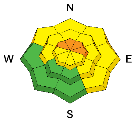
bottom line Most terrain has an overall MODERATE danger for increasingly stubborn wind drifts and loose snow avalanches. Isolated areas of CONSIDERABLE dot the landscape on steep northwest through east facing terrain above about 8000'. Plenty areas of LOW danger and excellent riding and recreating exist in sheltered terrain on slopes less steep than 35 degrees with nothing steeper above or adjacent to you. Slope angle is key here. Remember that even small avalanches can have significant consequences if riding in extreme terrain.
|
 |
special announcement Due to the popularity and response from our first ever Snowshoe Backcountry 101 classes this year, we are running one more this next week. The evening session will be this Wednesday, February 26, with the field day at Brighton on March 1. Sign up here. |
 |
current conditions Skies are mostly cloudy-becoming overcast this morning with temps in the teens and low 20s. These last couple days have reminded me of winter. Winds remain moderate to strong along the exposed ridgelines, blowing 30-40mph from the northwest. Skiing and riding conditions have been quite good over the last couple of days, though sun and wind has started to carve their slice of the pie. |
 |
recent activity The Ogden area mountains went through a significant avalanche cycle during the pineapple express early/mid-month with great photos by Brandon Everett here. Otherwise, most activity the last couple days have been cornice fall and shallow wind slabs and loose snow avalanches. |
| type | aspect/elevation | characteristics |
|---|

|
|
LIKELIHOOD
 LIKELY
UNLIKELY
SIZE
 LARGE
SMALL
TREND
 INCREASING DANGER
SAME
DECREASING DANGER
|
|
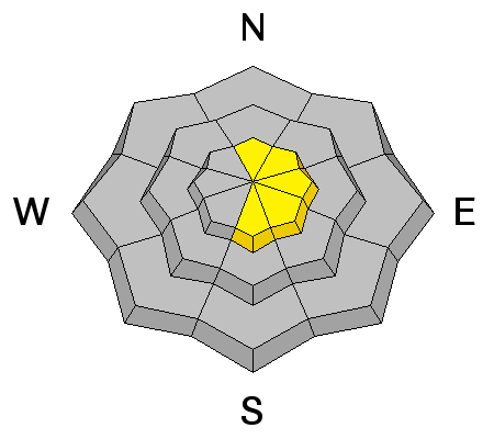
description
These deeper slabs are transitioning back to a low probability/high consequence regime...where triggering is unlikely and consequences are brutal. They are more pronounced on north to east facing slopes above about 8000'...and are likely triggered in thin rocky terrain... and certainly in the Western Uintas). It's also likely that heavier loads may be needed to crowbar out one of these deeper slides such as more than one snowmobile on the slope, a large cornice drop, another slide from above that steps down, or explosives. In this way, where likelihood is low and spatial distribution is uncertain, the safe bet is avoidance of the suspect terrain or sticking with slope angles approaching 35 degrees or less (* with nothing steeper above). |
| type | aspect/elevation | characteristics |
|---|

|

|
LIKELIHOOD
 LIKELY
UNLIKELY
SIZE
 LARGE
SMALL
TREND
 INCREASING DANGER
SAME
DECREASING DANGER
|
|
description
The wind blew hard from the west and northwest a couple days ago with the passage of the cold front, which created quite a bit of wind damage in the upper elevation, wind exposed terrain. Yesterday, the wind slabs were mostly soft and not very reactive but I'm sure you can find places today where one could catch and carry a person. You will find them mostly on northeast through southeast facing slopes. |
| type | aspect/elevation | characteristics |
|---|

|
|
LIKELIHOOD
LIKELY
UNLIKELY
SIZE
 LARGE
SMALL
TREND
INCREASING DANGER
SAME
DECREASING DANGER
|
|
description
Cornices are growing larger with sustained northwesterly winds and will break further back along the ridgelines than expected. Adding insult to injury, going over with one of these boxcars may result in triggering a deeper slide below. |
 |
weather With an amplifying ridge off to the west, moisture will be streaming down the backside into northern Utah throughout the day. Look for partly-becoming-mostly and then overcast skies, particularly in the northern part of our forecast area. Ogden and Logan may see a few flakes to a trace or so of snow. Cottonwoods and areas south may see periods of sun with Provo seeing partly cloudy skies. Temps will be in the upper teens to mid-20s with west to northwest winds blowing 20-25mph along the ridgelines. The amplifying ridge is undercut by a few disturbances early in the week with a couple storms noted on the distant radar for Thursday and again over the weekend. |
| general announcements
Remember your information can save lives. If you see anything we should know about, please participate in the creation of our own community avalanche advisory by submitting snow and avalanche conditions. You can also call us at 801-524-5304 or 800-662-4140, email by clicking HERE, or include #utavy in your tweet or Instagram. If you trigger an avalanche in the backcountry - especially if you are adjacent to a ski area – please call the following teams to alert them to the slide and whether anyone is missing or not. Rescue teams can be exposed to significant hazard when responding to avalanches, and do not want to do so when unneeded. Thanks. Salt Lake and Park City – Alta Central (801-742-2033), Canyons Resort Dispatch (435-615-3322) Snowbasin Resort Dispatch (801-620-1017), Powder Mountain Dispatch (801-745-3772 x 123). Sundance Dispatch (801-223-4150) EMAIL ADVISORY We have switched to a new SLC email advisory system. If you would like to get the daily advisory by email, or if you have been getting the advisory by email since the beginning of the season and wish to continue, you will need to subscribe here. DAWN PATROL Hotline updated daily by 5-530am - 888-999-4019 option 8. Twitter Updates for your mobile phone - DETAILS UDOT canyon closures: LINK TO UDOT Utah Avalanche Center mobile app - Get your advisory on your iPhone along with great navigation and rescue tools.uned. Wasatch Powderbird Guides Blog/Itinerary for the Day. Lost or Found something in the backcountry? - http://nolofo.com/ Discount lift tickets are now available at Backcountry.com - Thanks to Ski Utah and the Utah Resorts. All proceeds go towards paying for Utah Avalanche Center avalanche and mountain weather advisories. To those skinning uphill at resorts: it is your responsibility to know the resort policy on uphill travel. Some allow uphill travel and have guidelines, some don't. Contact the Ski Patrol at each resort for details. IMPORTANT: Before skinning at a resort under new snow conditions, check in with Ski Patrol. Resorts can restrict or cut off access if incompatible with control and grooming operations. Benefit the Utah Avalanche Center when you shop from Backcountry.com or REI: Click this link for Backcountry.com or this link to REI, shop, and they will donate a percent of your purchase price to the UAC. Both offer free shipping (with some conditions) so this costs you nothing! Benefit the Utah Avalanche Center when you buy or sell on ebay - set the Utah Avalanche Center as a favorite non-profit in your ebay account here and click on ebay gives when you buy or sell. You can choose to have your seller fees donated to the UAC, which doesn't cost you a penny. This information does not apply to developed ski areas or highways where avalanche control is normally done. This advisory is from the U.S.D.A. Forest Service, which is solely responsible for its content. This advisory describes general avalanche conditions and local variations always exist. |


_4.jpg)