
| During the month of April, Mark Miller will donate $75 to the charity of your choice (5 to chose from, including the Utah Avalanche Center!) Mark Miller Subaru has raised over $300k in the previous 6 Do Good Feel Good events. More Info here |  |
| During the month of April, Mark Miller will donate $75 to the charity of your choice (5 to chose from, including the Utah Avalanche Center!) Mark Miller Subaru has raised over $300k in the previous 6 Do Good Feel Good events. More Info here | |
| Advisory: Moab Area Mountains | Issued by Eric Trenbeath for Friday - December 6, 2013 - 6:42am |
|---|


|
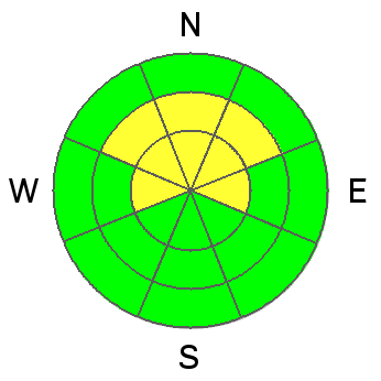
bottom line The bottom line is an overall MODERATE avalanche hazard on slopes steeper than 35 degrees above about 10,000 feet. Moderate hazard still means that human triggered avalanches are possible. The danger will be most pronounced on northerly aspects, and will increase with elevation and on more exposed terrain.
|
 |
current conditions It's going to be another cold day in the mountains under partly sunny skies. High temperatures will be in the single digits but winds will be very calm, averaging 5mph out of the SW. With mostly well behaved winds the past couple of days, snow conditions remain excellent after Wednesday's storm, which brought 10-14" of new snow to the mountains. All in all, things are starting off as good as I've ever seen around here. There is currently 22" on the ground at the Geyser Pass Trailhead, and 39" in Gold Basin. |
 |
recent activity Field work yesterday revealed a few isolated soft slab avalanches that likely ran during the storm. These occurred on extreme upper elevation slopes with N-NE aspects. They were confined to the most recent snow, and appeared as small pockets located on the lee side of exposed terrain features. |
| type | aspect/elevation | characteristics |
|---|

|
|
LIKELIHOOD
 LIKELY
UNLIKELY
SIZE
 LARGE
SMALL
TREND
 INCREASING DANGER
SAME
DECREASING DANGER
|
|
description
Upper elevation, northerly aspects have developed a significant layer of faceted snow above the ground. Though they have largely adjusted to the weight of new snow, persistent slabs from the storm event of November 23-25 still remain over top of the weak, faceted grains underneath. For an example of this see this avalanche from that storm cycle.http://utahavalanchecenter.org/avalanches/18789 Though these slabs will be hard to trigger, they are a veritable house of cards, and we will have to pay continual attention to them as more weight is added with future storms. |
| type | aspect/elevation | characteristics |
|---|

|

|
LIKELIHOOD
LIKELY
UNLIKELY
SIZE
 LARGE
SMALL
TREND
INCREASING DANGER
SAME
DECREASING DANGER
|
|
description
The second avalanche problem will be recent soft slabs from Wednesday's storm failing at the old snow surface.Surface hoar growth was massive during the last period between storms, and snow pits revealed a clearly defined weakness at the old snow interface. These slabs will mostly be found in isolated pockets on the lee sides of terrain features on upper elevation, wind exposed terrain with a northerly aspect. |
 |
weather Temperatures will continue to be cold today with highs in the single digits under partly sunny skies. Winds will be light out of the SW. Winds will increase and temperatures will warm slightly on Saturday as another storm moves into our area. Snow should start falling by Saturday afternoon, and we could see another foot of snow by Sunday. |
| general announcements LUNA Information: We plan to get the grooming equipment up to the GPTH on Saturday. There will be a meeting for all interested grooming volunteers next Saturday, December 14, at 8 a.m. at the MARC. ROAD CONDITIONS: Plow crews will be initiating road closures during plowing this season due to conflicts with traffic. The plan is to call me the day before they plan to plow so I can post it in this advisory. This closure could take up to two hours sop please plan accordingly. San Juan County has done an excellent job so far this year, and the road is clear for the weekend. Do not expect plowing over the weekend should we get new snow, and please keep in mind that their first priority after a storm is to open roads in and around populated areas.
|


_2.jpg)
