| During the month of April, Mark Miller will donate $75 to the charity of your choice (5 to chose from, including the Utah Avalanche Center!) Mark Miller Subaru has raised over $300k in the previous 6 Do Good Feel Good events. More Info here |  |
| During the month of April, Mark Miller will donate $75 to the charity of your choice (5 to chose from, including the Utah Avalanche Center!) Mark Miller Subaru has raised over $300k in the previous 6 Do Good Feel Good events. More Info here | |
| Advisory: Logan Area Mountains | Issued by Toby Weed for Thursday - February 6, 2014 - 7:13am |
|---|

|
bottom line Expect a rising avalanche danger in the backcountry with increasingly heavy snowfall, intensifying west winds, and gradually rising temperatures. Dangerous avalanche conditions and a Level 3 or CONSIDERABLE danger already exist this morning on some drifted upper and mid elevation slopes, and the danger will continue to rise and become more widespread as we head into the weekend. Careful snowpack evaluation, cautious route-finding, and conservative decision making will be essential for safe travel in the backcountry today.
|
 |
avalanche watch THIS AVALANCHE WATCH IS FOR ALL THE MOUNTAINS OF NORTHERN UTAH, WESTERN UINTAS AND THE WASATCH PLATEAU. A WINTER STORM WITH AN EXTENDED PERIOD OF SNOWFALL, INTENSIFYING WEST WIND, AND GRADUALLY WARMING TEMPERATURES WILL OVERLOAD EXISTING WEAK LAYERS OF SNOW. THIS WILL CREATE DANGEROUS AVALANCHE CONDITIONS IN THE BACKCOUNTRY. DRIFTING SNOW WILL CAUSE THE AVALANCHE DANGER TO RISE THROUGHOUT TODAY AND OVERNIGHT. DANGEROUS AVALANCHE CONDITIONS WILL LIKELY DEVELOP BY FRIDAY AND LAST THROUGH THE WEEKEND. THIS WATCH DOES NOT INCLUDE SKI AREAS OR HIGHWAYS WHERE AVALANCHE CONTROL IS NORMALLY DONE. |
 |
special announcement We are on for our ESSENTIAL AVALANCHE AND RIDING SKILLS WORKSHOP this Saturday February 8th. Meet at Providence Canyon Snowmobile Parking at 9am. (until 2 or 3pm) Bring beacon, shovel and probe. We'll have a few spares. We'll spend 1/2 the time going over avalanche skills and the other 1/2 learning how to really ride from Nate and crew. Registration here. Cost - $120 All proceeds benefit the Utah Avalanche Center in Logan. You can register the day of at the parking lot. |
 |
current conditions The Tony Grove Snotel at 8400' reports several more inches of light new snow in the last 24 hours containing 6/10ths of an inch of water. There's 68 inches of total snow containing 82% of average water for the date, and it's 10 degrees. It's 5 degrees at the 9700' Logan Peak weather station, and the wind sensor is still rimed, and so not reading accurately. The wind on Mt Ogden increased a bit overnight and is from the west southwest, averaging around 30 mph this morning. Observers report excellent and deepening powder conditions from the backcountry yesterday. Unfortunately with a prolonged winter storm already underway in the Logan Area Mountains, we can expect increasingly heavy snowfall, intensifying west winds, and gradually rising temperatures, which will waste the nice powder and create rising and dangerous avalanche conditions as we head into the weekend.
we can expect increasingly heavy snowfall, intensifying west winds, and gradually rising temperatures
|
 |
recent activity Locally; We noticed a fair amount of natural sluffing and some small soft slab activity in steep terrain over the last few days. An observer reported some natural persistent slab and wind slab avalanche activity from last weekend in Cottonwood Canyon in the Mount Naomi Wilderness. There were a number of triggered avalanches in the Central Wasatch backcountry yesterday, with at least 3 people caught and carried by avalanches they triggered, but thankfully and luckily no injuries. Check out our Observations Page...
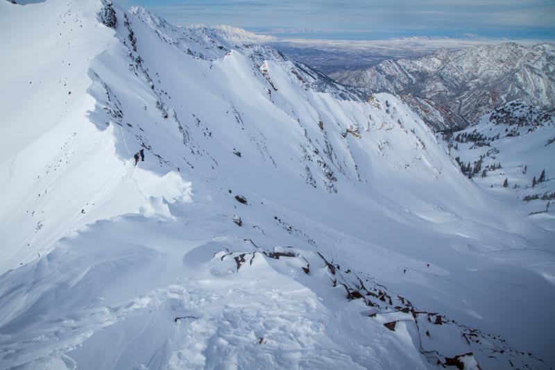
An avalanche in the Central Wasatch Range that caught and carried two backcountry skiers yesterday. (2-5-2014)
|
| type | aspect/elevation | characteristics |
|---|

|
|
LIKELIHOOD
 LIKELY
UNLIKELY
SIZE
 LARGE
SMALL
TREND
 INCREASING DANGER
SAME
DECREASING DANGER
|
|
description
The fresh snow from the last couple days and overnight is light and fluffy, and it won't take much wind to cause significant drifting. West winds increased overnight and will continue to pick up steam today and tonight. Dangerous soft wind slab conditions may already exist in some areas, and drifting will cause the danger to increase and become more widespread. You are likely to trigger wind slab avalanches up to around 2 feet deep, failing on weaker layers within the fresher snow or the sugary old snow surface from last week in steep drifted terrain, especially in upper elevation lee slope areas. Also, watch for and avoid stiffer wind deposited snow in and around terrain features like gullies, scoops, sub-ridges, and rock outcroppings or cliff bands at upper and mid elevations and on slopes facing all directions..
|
| type | aspect/elevation | characteristics |
|---|

|
|
LIKELIHOOD
 LIKELY
UNLIKELY
SIZE
 LARGE
SMALL
TREND
INCREASING DANGER
SAME
DECREASING DANGER
|
|
description
The danger of persistent slab avalanches will rise with the prolonged storm currently upon us. In areas where the preexisting snow is shallow it is very weak, and dangerous triggered persistent slab and/or deep slab avalanches failing on buried faceted weak layers are possible on some steep slopes. Persistent slab activity was observed locally at upper elevations last weekend, and chances are good that more slopes could be hanging in a state of balance with the fresh load from the last couple days. In some areas you still might trigger avalanches remotely, from a distance or even from the flats below steep slopes. We haven't seen the last of these tricky and persistent facets by any means, they are just lying in dormancy for the time being. Trent Meisenheimer released a great video last week about persistent slab avalanches. View it ...HERE
|
| type | aspect/elevation | characteristics |
|---|

|
|
LIKELIHOOD
LIKELY
UNLIKELY
SIZE
LARGE
SMALL
TREND
INCREASING DANGER
SAME
DECREASING DANGER
|
|
description
With all new powdery snow piling up and increasing snow densities due to gradually warming temperatures, expect to find the fresh snow becoming inverted or a little heavier in the upper layers. Soft storm slabs and loose sluffs entraining significant amounts of fresh snow will become more likely in steep terrain. Avoid terrain traps and steep slopes where you might be swept into trees or rocks below. |
 |
weather More snow is a given today, with 3 to 7 inches of accumulation forecast. Expect 8500' high temperatures around 15 degrees and 15 to 20 mph west southwest winds on the ridges. Overnight an additional 4 to 8 inches of snowfall is expected, with west southwest winds increasing into the 20 to 25 mph range and gusts around 40. Expect dangerous avalanche conditions tomorrow and some serious winter weather, with somewhat warmer temperatures, 10 to 14 inches of snow and even stronger west winds, 25 to 35 mph, with gusts in the mid fifties. The storm will continue with some strength into the weekend, with gradually warming temperatures. Check out our one-stop weather page........HERE |
| general announcements On Feb 6 (evening) and Feb 8 (field day), Craig Gordon will lead an avalanche class at Snowbasin for Sidecountry skiers and snowboarders. Learn how to make smart decisions riding in the backcountry on the other side of the resort boundary, riding powder and coming home alive. HERE For a safer powder option; Discount lift tickets are available at Backcountry.com - Thanks to Ski Utah and the Utah Resorts, including Beaver Mountain. All proceeds go towards paying for Utah Avalanche Center avalanche and mountain weather advisories. Utah Avalanche Center mobile app - Get your advisory on your iPhone along with great navigation and rescue tools. Remember your information can save lives. If you see anything we should know about, please participate in the creation of our own community avalanche advisory by submitting snow and avalanche conditions. You can also call us at 801-524-5304 or 800-662-4140, email by clicking HERE, or include #utavy in your tweet or Instagram. Follow us at UAClogan on Twitter I'll issue these advisories on Monday, Wednesday, Friday, and Saturday mornings. This advisory is produced by the U.S.D.A. Forest Service, which is solely responsible for its content. It describes only general avalanche conditions and local variations always exist. |


_1.jpg)