| During the month of April, Mark Miller will donate $75 to the charity of your choice (5 to chose from, including the Utah Avalanche Center!) Mark Miller Subaru has raised over $300k in the previous 6 Do Good Feel Good events. More Info here |  |
| During the month of April, Mark Miller will donate $75 to the charity of your choice (5 to chose from, including the Utah Avalanche Center!) Mark Miller Subaru has raised over $300k in the previous 6 Do Good Feel Good events. More Info here | |
| Advisory: Logan Area Mountains | Issued by Toby Weed for Tuesday - February 4, 2014 - 7:22am |
|---|


|
bottom line Heightened avalanche conditions exist, and there is a Level 2 or MODERATE danger on many steep drifted slopes in the backcountry. There could be some areas with more dangerous conditions, and the danger is CONSIDERABLE or Level 3 on drifted upper elevation slopes. Dangerous persistent slab avalanches stepping down into weak faceted old snow are possible in some areas, and in some cases might be triggered remotely, from a distance, or the flats below steep slopes. You are likely to trigger wind slab avalanches up to 2 feet deep on drifted upper elevation slopes, and mostly manageable sluffs and shallow soft wind slabs are likely on steep slopes in areas that picked up significant accumulations overnight. Careful snowpack evaluation, cautious route-finding, and conservative decision making will be essential for safe travel in the backcountry.
|
 |
special announcement We are on for our ESSENTIAL AVALANCHE AND RIDING SKILLS WORKSHOP this Saturday February 8th. Meet at Providence Canyon Snowmobile Parking at 9am. (until 2 or 3pm) Bring beacon, shovel and probe. We'll have a few spares. We'll spend 1/2 the time going over avalanche skills and the other 1/2 learning how to really ride from Nate and crew. Registration here. Cost - $120 All proceeds benefit the Utah Avalanche Center in Logan. You can register the day of at the parking lot. |
 |
current conditions The Tony Grove Snotel at 8400' reports 9 more inches of light new snow in the last 24 hours containing only a 1/2 inch of water. There's 68 inches of total snow and it's a bone chilling 4 degrees. It's minus 1 degree at the 9700' Logan Peak weather station, and the wind sensor is still rimed, and so not reading accurately. The wind on Mt Ogden is from the northwest, averaging in the teens currently but around 20 mph overnight. We've been finding super nice shallow powder conditions, with a mostly supportable base at mid and higher elevations, but you still feel the rain-crust from last Wednesday and you drop through it into very soft sugary snow at times down lower. It appears that the powder or cold smoke will be a fair bit deeper today.
Riding in shallow powder yesterday. Looks like it'll be a bit deeper today.
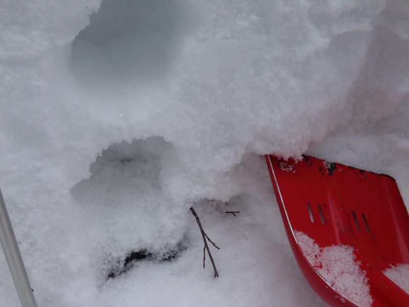
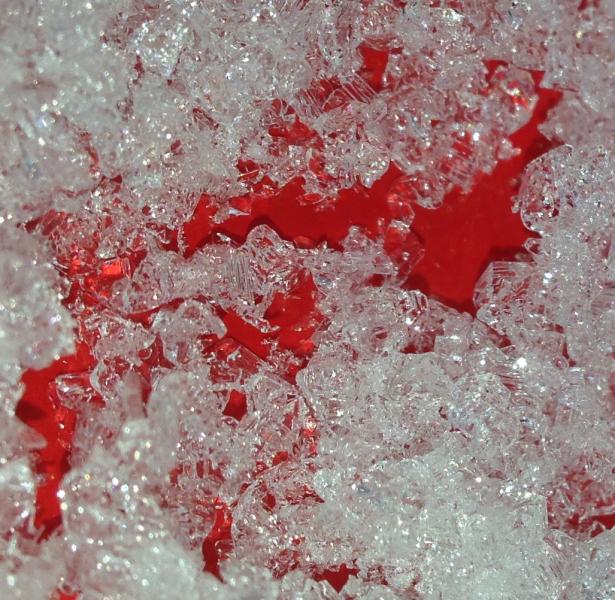
The shallow mid-elevation snow is faceted and very weak, especially in the basal layers. This is depth hoar in Beaver Canyon, 2-2-2014 (Weed).
|
 |
recent activity Ski resorts in the Ogden Mountains report increased wind slab activity, and snow safety teams were able to trigger 1 to 2 foot deep wind slab avalanches in drifted terrain yesterday afternoon. Locally; backcountry skiers back from the Blind Hollow Yurt report some natural persistent slab and fresh wind slab avalanche activity from over the weekend in Cottonwood Canyon in the Mount Naomi Wilderness (report), and I could see evidence of shallow soft slab and loose snow activity off the south ridge of Mt. Magog yesterday.
|
| type | aspect/elevation | characteristics |
|---|

|
|
LIKELIHOOD
 LIKELY
UNLIKELY
SIZE
 LARGE
SMALL
TREND
 INCREASING DANGER
SAME
DECREASING DANGER
|
|
description
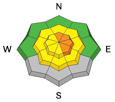
The fresh snow from the last couple days and overnight is light and fluffy, and it won't take much wind to cause significant drifting. Dangerous soft wind slab conditions may already exist in some areas, and any increase or shift in wind will cause the danger to increase and become more widespread. You are likely to trigger wind slab avalanches up to around 2 feet deep, failing on the sugary old snow surface from last week in steep drifted terrain, especially in upper elevation lee slope areas. Also, watch for and avoid stiffer wind deposited snow in and around terrain features like gullies, scoops, sub-ridges, and rock outcroppings or cliff bands at upper and mid elevations and on slopes facing all directions..
We easily cracked out small drifts on the ridge-line yesterday. Slope too low angled for them to move far.
|
| type | aspect/elevation | characteristics |
|---|

|
|
LIKELIHOOD
 LIKELY
UNLIKELY
SIZE
 LARGE
SMALL
TREND
 INCREASING DANGER
SAME
DECREASING DANGER
|
|
description
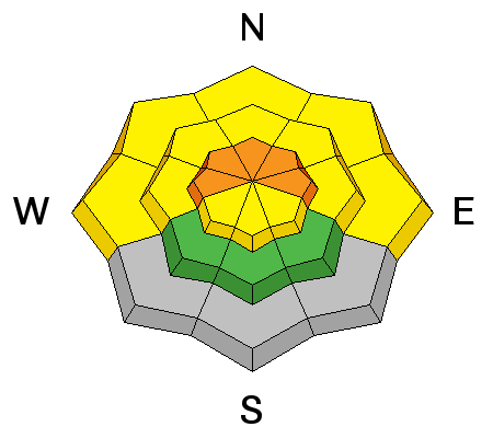
In areas where the preexisting snow is shallow it is very weak, and dangerous triggered persistent slab and/or deep slab avalanches failing on buried faceted weak layers are possible on some steep slopes. The added load from last night's light snow probably won't be enough to tip the scales in most areas, but it might be in some. Persistent slab activity was observed locally at upper elevations over the weekend, and chances are good that more will with the fresh load from overnight. In some areas you still might trigger avalanches remotely, from a distance or even from the flats below steep slopes. We haven't seen the last of these pesky facets by any means, they are just lying in dormancy. Trent Meisenheimer released a great video last week about persistent slab avalanches. View it ...HERE
|
| type | aspect/elevation | characteristics |
|---|

|

|
LIKELIHOOD
LIKELY
UNLIKELY
SIZE
 LARGE
SMALL
TREND
INCREASING DANGER
SAME
DECREASING DANGER
|
|
description
With all the light fluffy snow, mostly manageable sluffs and shallow soft wind slabs are likely in steep terrain. Avoid terrain traps and steep slopes where you might be swept into trees or rocks below. |
 |
weather We'll see lingering snow showers and pretty cold temperatures with a high of around 7 degrees but dropping to around 4 this afternoon. Moderate west winds will swing around from the south this morning, and another 1 or 2 inches of accumulation is possible. The weather will remain cold and unsettled in the mountains through the work week, with a stronger storm expected to impact the entire state around Thursday. Check out our one-stop weather page........HERE |
| general announcements On Feb 6 (evening) and Feb 8 (field day), Craig Gordon will lead an avalanche class at Snowbasin for Sidecountry skiers and snowboarders. Learn how to make smart decisions riding in the backcountry on the other side of the resort boundary, riding powder and coming home alive. HERE For a safer powder option; Discount lift tickets are available at Backcountry.com - Thanks to Ski Utah and the Utah Resorts, including Beaver Mountain. All proceeds go towards paying for Utah Avalanche Center avalanche and mountain weather advisories. Utah Avalanche Center mobile app - Get your advisory on your iPhone along with great navigation and rescue tools. Remember your information can save lives. If you see anything we should know about, please participate in the creation of our own community avalanche advisory by submitting snow and avalanche conditions. You can also call us at 801-524-5304 or 800-662-4140, email by clicking HERE, or include #utavy in your tweet or Instagram. Follow us at UAClogan on Twitter I'll issue these advisories on Monday, Wednesday, Friday, and Saturday mornings. This advisory is produced by the U.S.D.A. Forest Service, which is solely responsible for its content. It describes only general avalanche conditions and local variations always exist. |


_1.jpg)