| During the month of April, Mark Miller will donate $75 to the charity of your choice (5 to chose from, including the Utah Avalanche Center!) Mark Miller Subaru has raised over $300k in the previous 6 Do Good Feel Good events. More Info here |  |
| During the month of April, Mark Miller will donate $75 to the charity of your choice (5 to chose from, including the Utah Avalanche Center!) Mark Miller Subaru has raised over $300k in the previous 6 Do Good Feel Good events. More Info here | |
| Advisory: Logan Area Mountains | Issued by Toby Weed for Monday - February 3, 2014 - 7:11am |
|---|

|
bottom line Heightened avalanche conditions exist, and there is a Level 2 or MODERATE danger on steep drifted slopes in the backcountry. Triggered wind slab avalanches 1 to 2 feet deep are possible on steep drifted slopes, and sluffs and shallow soft wind slabs will become more likely with significant accumulations possible in some areas by evening. Although existing widespread persistent weak layers appear dormant currently, dangerous persistent slab avalanches stepping down into weak faceted old snow are possible in some areas and in some cases might be triggered remotely, from a distance, or the flats below steep slopes. Evaluate the snow and terrain carefully, and continue to avoid steep drifted slopes.
|
 |
special announcement Avalanche accidents are common when the danger is MODERATE, so continue to use strict safe travel protocols.
|
 |
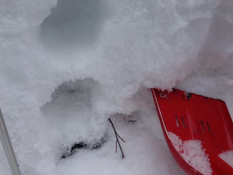
current conditions The Tony Grove Snotel at 8400' reports a couple more inches of new snow in the last 24 hours, it's 9 degrees and there's 60 inches of total snow containing somewhere around 80% of average water content for the date. It's 6 degrees at the 9700' Logan Peak weather station, and the wind sensor is still rimed, and not reading accurately. The wind on Mt Ogden is from the southwest, averaging around 20 mph. You'll find nice shallow powder conditions, with a mostly supportable base at mid and higher elevations, but you still feel the rain-crust from last Wednesday and you drop through it into very soft sugary snow at times down lower.
The shallow mid-elevation snow is faceted and very weak, especially in the basal layers. This is depth hoar in Beaver Canyon, 2-2-2014 (Weed).
|
 |
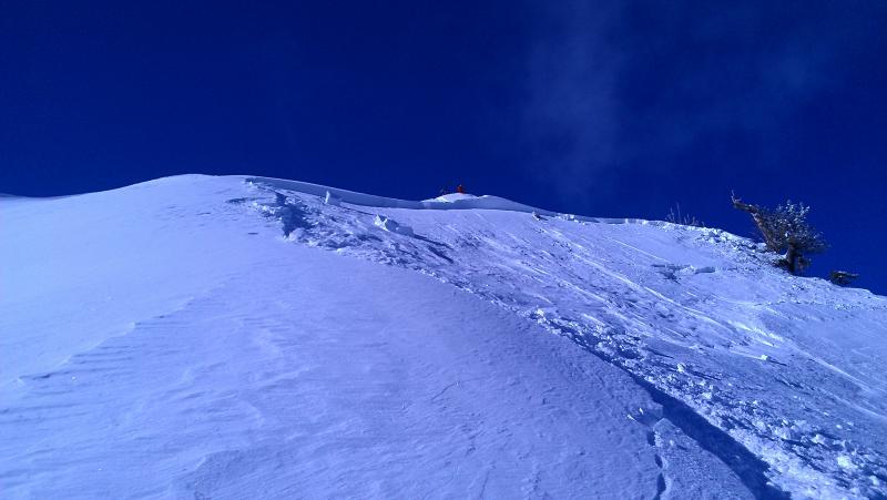
recent activity Backcountry skiers remote triggered a large deep slab avalanche in the Wasatch Range in the Provo Mountains yesterday. Otherwise, sluffs and shallow soft slabs have been common in the last few days. Locally; other than expected wet activity at low elevations in Logan Canyon due to last Wednesday's rain, no new avalanches have been reported since our very active and lucky deep slab cycle during the second weekend in 2014.
Remote triggered avalanche from Yesterday in the Wasatch Range. Report HERE.
|
| type | aspect/elevation | characteristics |
|---|

|

|
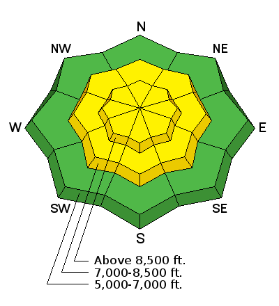
LIKELIHOOD
 LIKELY
UNLIKELY
SIZE
 LARGE
SMALL
TREND
 INCREASING DANGER
SAME
DECREASING DANGER
|
|
description
In areas where the preexisting snow is shallow it is very weak, and dangerous triggered persistent slab and/or deep slab avalanches failing on buried faceted weak layers are possible on steep slopes. Although persistent slab activity was not yet observed locally since the mild midweek storm, in some areas you still might trigger avalanches remotely, from a distance or even from the flats below steep slopes. We haven't seen the last of these pesky facets by any means, they are just lying in dormancy. Trent Meisenheimer released a great video last week about persistent slab avalanches. View it ...HERE
|
| type | aspect/elevation | characteristics |
|---|

|

|
LIKELIHOOD
 LIKELY
UNLIKELY
SIZE
 LARGE
SMALL
TREND
INCREASING DANGER
SAME
DECREASING DANGER
|
|
description
The heavy new snow from Wednesday appears to be fairly well behaved, and no significant wind slab avalanches were observed or reported locally. But, backcountry riders triggered a handful of avalanches in the Wasatch Range, and my snowpit tests show instability, with small grained near surface facets on the old snow interface. Wind slabs 1 to 2 feet deep, failing on the sugary old snow surface are possible in drifted terrain, especially in upper elevation lee slope areas. Also, watch for and avoid stiffer wind deposited snow in and around terrain features like gullies, scoops, sub-ridges, and rock bands or cliffs at upper elevations and on slopes facing all directions..
|
| type | aspect/elevation | characteristics |
|---|

|
|
LIKELIHOOD
 LIKELY
UNLIKELY
SIZE
 LARGE
SMALL
TREND
INCREASING DANGER
SAME
DECREASING DANGER
|
|
description
Significant accumulations of light density snow are likely in some areas by evening, and sluffs and shallow soft wind slabs will become increasingly likely in steep terrain. |
 |
weather Snow is likely today, intensifying this afternoon, with 2 to 4 inches of light density forecast in the mountains by evening and another 4 to 8 possible overnight tonight. Expect 8500' high temperatures of 17 degrees and moderate southwest wind. Temperatures will drop to around 2 degrees tonight and winds will shift around from the west northwest. We'll see lingering snow showers tomorrow and pretty cold temperatures with a high of around 7 degrees. The weather will remain cold and unsettled in the mountains through the work week, with a stronger storm expected to impact the entire state later in the week. Check out our one-stop weather page........HERE |
| general announcements On Feb 6 (evening) and Feb 8 (field day), Craig Gordon will lead an avalanche class at Snowbasin for Sidecountry skiers and snowboarders. Learn how to make smart decisions riding in the backcountry on the other side of the resort boundary, riding powder and coming home alive. HERE For a safer powder option; Discount lift tickets are available at Backcountry.com - Thanks to Ski Utah and the Utah Resorts, including Beaver Mountain. All proceeds go towards paying for Utah Avalanche Center avalanche and mountain weather advisories. Utah Avalanche Center mobile app - Get your advisory on your iPhone along with great navigation and rescue tools. Remember your information can save lives. If you see anything we should know about, please participate in the creation of our own community avalanche advisory by submitting snow and avalanche conditions. You can also call us at 801-524-5304 or 800-662-4140, email by clicking HERE, or include #utavy in your tweet or Instagram. Follow us at UAClogan on Twitter I'll issue these advisories on Monday, Wednesday, Friday, and Saturday mornings. This advisory is produced by the U.S.D.A. Forest Service, which is solely responsible for its content. It describes only general avalanche conditions and local variations always exist. |


_1.jpg)