| During the month of April, Mark Miller will donate $75 to the charity of your choice (5 to chose from, including the Utah Avalanche Center!) Mark Miller Subaru has raised over $300k in the previous 6 Do Good Feel Good events. More Info here |  |
| During the month of April, Mark Miller will donate $75 to the charity of your choice (5 to chose from, including the Utah Avalanche Center!) Mark Miller Subaru has raised over $300k in the previous 6 Do Good Feel Good events. More Info here | |
| Advisory: Logan Area Mountains | Issued by Toby Weed for Friday - January 24, 2014 - 6:49am |
|---|

|
bottom line Heightened avalanche conditions exist, and there's a Level 2 or MODERATE danger in the backcountry. You could trigger dangerous and destructive persistent slab avalanches on slopes with poor snow structure, where a thicker or more cohesive slab sits on top of very weak sugary or faceted snow. The danger is greatest in extreme terrain and on very steep drifted upper elevation north, northeast, and east facing slopes that have not already avalanched. Shallower areas on an existing slab are potential trigger points. Although becoming less likely, in some areas you still might trigger dangerous avalanches remotely, meaning from a distance or below. Evaluate the snow and terrain carefully, and continue to avoid very steep previously drifted slopes.
|
 |
current conditions The Tony Grove Snotel at 8400' reports 26 degrees and 47 inches of total snow containing 75% of average water content for the date. It's 24 degrees at the 9700' Logan Peak weather station, and I'm reading west northwest winds averaging a bit less than 20 mph this morning Heightened avalanche conditions remain on steep slopes in the backcountry, especially at upper elevations. Despite widespread poor snow structure, stability is gradually increasing with time, and it is growing ever more unlikely that you could trigger a dangerous persistent slab avalanche. Problem is, if you do trigger one, it could be large, destructive, and potentially deadly.. You can find pretty good settled powder conditions in sheltered terrain, but we're starting to drop through deteriorating supportable surface snow into loose bottomless facets again, especially at mid elevations. Sunny slopes are a bit crusty and lots of upper elevation slopes are wind-jacked or scoured to the ground. I've been finding pretty good conditions near the flanks or in drifted-in areas on the bed surfaces of some of the large avalanches from a couple weeks ago.
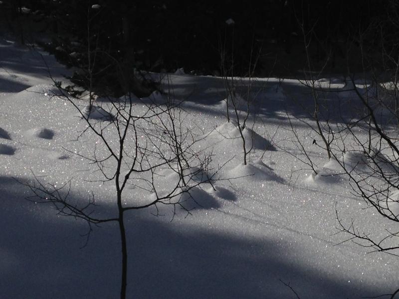
Surface hoar of frost is widespread in the snow surface in sheltered terrain. Note the good sized settlement cones around aspen stems nearly two weeks after the storm.
|
 |
recent activity Ted Scroggin of the UWC National Forest observed a few eye-opening recent sled triggered deep slabs on the Northern Slope of the western Uinta Range yesterday. Looks like the activity was from earlier in the week. Remember, if you trigger an avalanche in the backcountry, we'd really like to hear about it. This information could help to save lives....
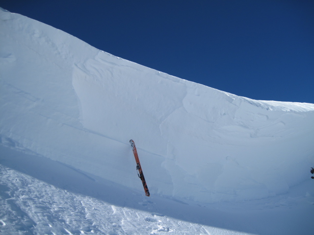
Ted took a picture of this 4-meter-deep crown of a recent triggered deep slab avalanche in Whitney Basin on the north slope of the Western Uinta Range.
|
| type | aspect/elevation | characteristics |
|---|

|
|
LIKELIHOOD
 LIKELY
UNLIKELY
SIZE
 LARGE
SMALL
TREND
 INCREASING DANGER
SAME
DECREASING DANGER
|
|
description
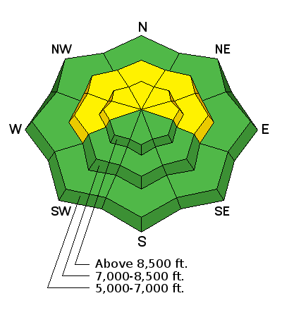
The danger deep or persistent slab avalanches is gradually decreasing, but you still could trigger large and destructive avalanches, especially on very steep previously drifted slopes at upper elevations that didn't avalanche during the impressive cycle almost two weeks ago. North, northeast, and east facing slopes above around 8000' in elevation are the most suspect. Although now rather unlikely, it still may be possible to remote trigger deep slab avalanches in the area, and you still might be able to trigger large avalanches from the flats below very steep slopes... Audible collapsing and shooting cracks are relevant red flags. |
 |
weather It'll be mostly sunny again today, with 8500' high temperatures around 34 degrees and a moderate northwest wind. High pressure conditions will strengthen and the inversion will control the valley weather through at least the weekend. A weather disturbance dropping out of Western Canada will likely graze our region on around Monday night, and some light snowfall is possible in the mountains of northern Utah. But the entrenched high pressure system over the west coast will keep most of the weather well to our north and east through midweek. The models hint at a change to a more moist pattern toward the end of next week, but it's too far away to get our hopes up yet. Check out our one-stop weather page........HERE |
| general announcements For a safer powder option; Discount lift tickets are available at Backcountry.com - Thanks to Ski Utah and the Utah Resorts, including Beaver Mountain. All proceeds go towards paying for Utah Avalanche Center avalanche and mountain weather advisories. Utah Avalanche Center mobile app - Get your advisory on your iPhone along with great navigation and rescue tools. Remember your information can save lives. If you see anything we should know about, please participate in the creation of our own community avalanche advisory by submitting snow and avalanche conditions. You can also call us at 801-524-5304 or 800-662-4140, email by clicking HERE, or include #utavy in your tweet or Instagram. Follow us at UAClogan on Twitter I'll issue these advisories on Monday, Wednesday, Friday, and Saturday mornings. This advisory is produced by the U.S.D.A. Forest Service, which is solely responsible for its content. It describes only general avalanche conditions and local variations always exist. |


_1.jpg)