| During the month of April, Mark Miller will donate $75 to the charity of your choice (5 to chose from, including the Utah Avalanche Center!) Mark Miller Subaru has raised over $300k in the previous 6 Do Good Feel Good events. More Info here |  |
| During the month of April, Mark Miller will donate $75 to the charity of your choice (5 to chose from, including the Utah Avalanche Center!) Mark Miller Subaru has raised over $300k in the previous 6 Do Good Feel Good events. More Info here | |
| Advisory: Logan Area Mountains | Issued by Toby Weed for Monday - January 20, 2014 - 6:59am |
|---|

|
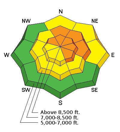
bottom line There is a Level 3 or CONSIDERABLE danger in the backcountry, and you could trigger very dangerous triggered deep slab avalanches on steep drifted upper elevation slopes with poor snow structure that have not already avalanched. Upper elevation north, northeast, and east facing slopes appear to be the most dangerous, and you could trigger dangerous avalanches remotely, meaning from a distance or below. Triggered wet avalanches will become possible on some steep sunny slopes with midday warming. Careful snowpack evaluation, cautious route-finding, and conservative decision making will be essential for safe travel in the backcountry. Continue to avoid and stay out from under steep drifted slopes that have not yet avalanched.
|
 |
special announcement
The Utah Avalanche Center in Logan is offering two upcoming avalanche awareness classes. On January 23 and 25, we are offering an advanced awareness class for those wanting to refresh their skills or learn more about traveling safely in avalanche terrain. And on February 15, the center is teaming up with the ZBROS to offer a combined riding skills and essential avalanche skills field day for snowmobilers. Come join us to learn more about how to stay safe in the backcountry. More information and registration is available on our website or by calling 435-757-2794. Visit our list of upcoming classes..........HERE |
 |
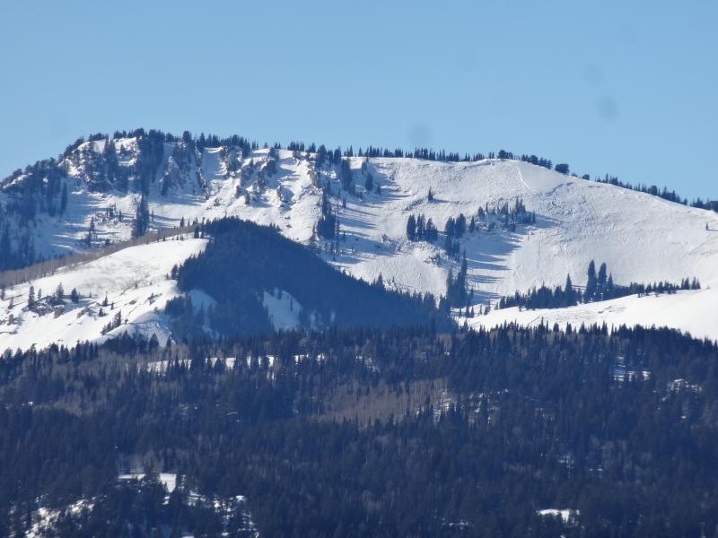
current conditions The Tony Grove Snotel at 8400' reports 33 degrees and 48 inches of total snow containing 80% of average water content for the date. It's 22 degrees at the 9700' Logan Peak weather station, and I'm reading northwest winds averaging around 20 mph overnight. Dangerous avalanche conditions remain on some slopes in the backcountry, especially at upper elevations. You can find pretty good and safer settled powder conditions in sheltered lower angled terrain, but sunny slopes are a bit crusty and lots of upper elevation slopes are either wind-jacked or have recently avalanched to the ground during an active natural avalanche cycle a week ago now.
Bellicosity Bowl, just one in a long list of large natural avalanches observed from last week's cycle on upper elevation north and east facing slopes in the Bear River Range.
|
 |
recent activity On Friday, a Utah rider triggered a large deep slab avalanche above Bloomington Lake in southeast Idaho. He was caught and carried, but was able to accelerate out of and escape the avalanche as it hit the lake with huge pile of debris and enough force to break the ice around the shores of the lake. Report....... HERE
This large triggered avalanche north of the Idaho state line almost got another lucky Utah rider on Friday. The rider escaped on his sled as the avalanche hit Bloomington Lake with enough force to break the ice around the rim of the lake! (Buttars)
|
| type | aspect/elevation | characteristics |
|---|

|
|
LIKELIHOOD
 LIKELY
UNLIKELY
SIZE
 LARGE
SMALL
TREND
 INCREASING DANGER
SAME
DECREASING DANGER
|
|
description
The danger of very dangerous deep slab avalanches is gradually decreasing, but you still could trigger potentially huge and destructive avalanches, especially on steep previously drifted slopes at upper elevations that haven't yet avalanched. Most of the observed avalanches from last week's natural cycle were on north through east facing slopes, but an exception on a northwest facing slope was observed in upper High Creek Canyon in the Mount Naomi Wilderness. It is still possible to remote trigger deep slab avalanches in the area, and you still might be able to trigger large avalanches from the flats below... Audible collapsing and shooting cracks are relevant red flags, but you should plan to continue to avoid and stay out from under steep previously drifted slopes anyway. |
| type | aspect/elevation | characteristics |
|---|

|
|
LIKELIHOOD
 LIKELY
UNLIKELY
SIZE
 LARGE
SMALL
TREND
 INCREASING DANGER
SAME
DECREASING DANGER
|
|
description
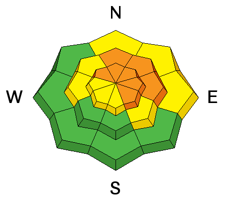
Wet avalanches are possible on steep sunny slopes with moist surface snow, especially during midday heating. |
 |
weather It will be warm and sunny in the mountains today, with moderate west northwest wind, and 8500' high temperatures around 40 degrees. Expect fair and sunny weather in the mountains again tomorrow and for the next few days. There's a chance of a little bit of snow around Wednesday night and Thursday, but don't get your hopes up, as accumulations will be light if there are any. Check out our one-stop weather page........HERE |
| general announcements For a safer powder option; Discount lift tickets are available at Backcountry.com - Thanks to Ski Utah and the Utah Resorts, including Beaver Mountain. All proceeds go towards paying for Utah Avalanche Center avalanche and mountain weather advisories. Utah Avalanche Center mobile app - Get your advisory on your iPhone along with great navigation and rescue tools. Remember your information can save lives. If you see anything we should know about, please participate in the creation of our own community avalanche advisory by submitting snow and avalanche conditions. You can also call us at 801-524-5304 or 800-662-4140, email by clicking HERE, or include #utavy in your tweet or Instagram. Follow us at UAClogan on Twitter I'll issue these advisories on Monday, Wednesday, Friday, and Saturday mornings. This advisory is produced by the U.S.D.A. Forest Service, which is solely responsible for its content. It describes only general avalanche conditions and local variations always exist. |


_1.jpg)