| During the month of April, Mark Miller will donate $75 to the charity of your choice (5 to chose from, including the Utah Avalanche Center!) Mark Miller Subaru has raised over $300k in the previous 6 Do Good Feel Good events. More Info here |  |
| During the month of April, Mark Miller will donate $75 to the charity of your choice (5 to chose from, including the Utah Avalanche Center!) Mark Miller Subaru has raised over $300k in the previous 6 Do Good Feel Good events. More Info here | |
| Advisory: Logan Area Mountains | Issued by Toby Weed for Saturday - January 4, 2014 - 6:51am |
|---|

|
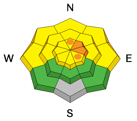
bottom line Heightened avalanche conditions exist in the Logan Area backcountry, and there is a Level 2 or MODERATE danger on many drifted slopes. Wind and persistent slab avalanches are possible in drifted terrain, and most likely at upper elevations. Drifting from strong westerly winds yesterday created more dangerous conditions in some areas, and you'll find a Level 3 or CONSIDERABLE danger on drifted upper elevation slopes facing the northeastern third of the compass. Careful snowpack evaluation, cautious route-finding, and conservative decision making will be essential for safe travel in the backcountry this weekend. Continue to avoid steep drifted slopes, especially at upper elevations.
|
 |
special announcement -Sign up now for our Avalanche 101 course to be held in Logan on January 9 and 11................. Information and registration -The Utah Avalanche Center along with the Montana State University Ski Tracks project combines GPS technology with detailed logbook surveys completed by participants to help us understand how and why decisions are made in the winter backcountry. Participants will use a free smartphone app to record and send us their ski routes then, they will complete a simple online survey telling us some of the features of their tour. For more information visit: www.montana.edu/snowscience/tracks
|
 |
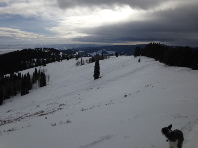
current conditions The Tony Grove Snotel at 8400' reports an inch of new snow overnight. It's 14 degrees this morning, and there is 34 inches of total snow containing 67% of average water content for the date. The 9700' Logan Peak weather station reports 6 degrees and northwest wind, currently averaging in the teens, after sustaining 35+ mph hourly averages yesterday. Throughout the past week we've found nice smooth and fast shallow powder conditions in lower angled terrain. Many areas are still quite punchy, and you easily sink down into structureless sugary snow all the way to the ground. You'll find pockets of dangerous avalanche conditions in drifted terrain at upper elevations in the Logan Area backcountry. Any steep slope with a stiffer slab overlying weak sugary or faceted snow is suspect.
The weak snow is shallow and punchy in the Garden City Bowls. 1-3-2014 (Pagnucco)
***Here's a video observation with telling snow pit results from Steep Hollow recorded on 1-2-2014.........HERE Please hit like it if you do.
|
 |
recent activity No new avalanches were reported in the Logan Area during the last week.... We continue to observe and receive reports of occasional audible collapsing in lower angled upper elevation terrain. The woompfing indicates unstable snow conditions.
|
| type | aspect/elevation | characteristics |
|---|

|
|
LIKELIHOOD
 LIKELY
UNLIKELY
SIZE
 LARGE
SMALL
TREND
 INCREASING DANGER
SAME
DECREASING DANGER
|
|
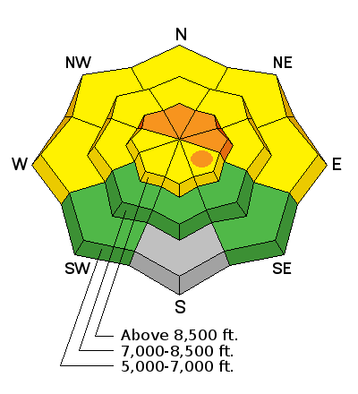
description
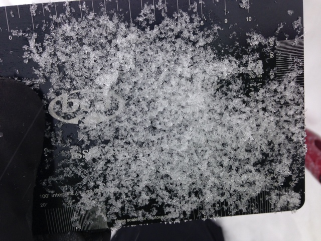
Dangerous human triggered avalanches failing in old weak faceted snow or in the basal layers of the existing snow pack are probable in some areas facing northwest through north and northeast, especially in drifted upper elevation terrain. Drifting with strong west winds yesterday and sustained northwest wind today increases the danger of persistent slab avalanches. Suspect slopes have a developing slab on top of the weak faceted basal snow, but I am unwilling to check for this poor structure. There are hundreds of avalanche prone slopes in the area that remain untracked and untested due to the dangerously shallow snowpack. Among these are many that I don't dare to get out on.
Very weak faceted snow is widespread across the Logan Zone. In most areas you sink right through structureless grains to the ground. Anywhere a more cohesive slab formed or is forming on top of this crap is suspect. 1-3-2014 (Pagnucco) |
| type | aspect/elevation | characteristics |
|---|

|
|
LIKELIHOOD
 LIKELY
UNLIKELY
SIZE
 LARGE
SMALL
TREND
 INCREASING DANGER
SAME
DECREASING DANGER
|
|
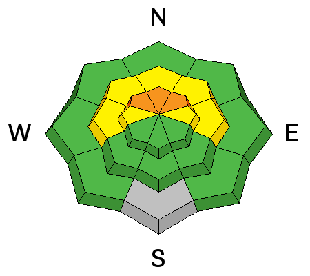
description
Drifting yesterday and perhaps continuing today built fresh stiff wind slabs, in many cases on top of very weak preexisting faceted snow or perhaps on surface hoar. Heightened wind slab avalanche conditions exist in exposed upper and mid-elevation terrain, and pockets of more dangerous conditions can be found on drifted upper elevation slopes facing north, northeast , and east. Triggered wind slab avalanches are possible today on steep slopes with recent and older deposits of drifted snow. Hard slabs have a nasty tendency to let one get well out on them before releasing. You'll find wind slabs composed of stiffer snow in areas where decelerating winds deposit drifting snow. Wind slabs form on the lee side of exposed ridge lines, but can also form on any slope aspect, especially in and around terrain features like gullies, scoops, sub-ridges, rock outcroppings, and cliff bands. As usual, you should continue to avoid steep slopes with recent wind deposits, which are often smooth, rounded and chalky looking, and can sound hollow or drum-like.
|
 |
weather It'll be cloudy, with a few snow showers today as the latest impulse moves off to the south and east. Mountain temperatures will drop during the day, with single digit readings expected by evening. It'll be fairly breezy, with moderate chilly northwest winds expected. A high pressure system will begin to rebuild over the region through the early part of the coming work week, and the nasty inversion will return to Cache Valley after a much needed break today. A couple weak impulses are expected during the middle of the week, and some snow is possible is possible in the mountains, though accumulations will be light. A deeper trough is expected to bring a good chance for significant snow later in the week, but the timing and location of this storm are still hard to pinpoint. Check out our one stop weather page........HERE |
| general announcements The Utah Avalanche Center wishes you a safe and powder-filled holiday season. Please consider the UAC in your holiday giving plans - your donations pay for these advisories and we can't do this without your help. What is it worth to you every day to get an avalanche and mountain weather advisory? The cost of a beverage or the gas it takes to get up the canyon? You can donate here. Utah Avalanche Center mobile app - Get your advisory on your iPhone along with great navigation and rescue tools. Discount lift tickets are now available at Backcountry.com - Thanks to Ski Utah and the Utah Resorts, including Beaver Mountain. All proceeds go towards paying for Utah Avalanche Center avalanche and mountain weather advisories. Benefit the Utah Avalanche Center when you shop from Backcountry.com or REI: Click this link for Backcountry.com or this link to REI, shop, and they will donate a percent of your purchase price to the UAC. Both offer free shipping (with some conditions) so this costs you nothing! Benefit the Utah Avalanche Center when you buy or sell on ebay - set the Utah Avalanche Center as a favorite non-profit in your ebay account here and click on ebay gives when you buy or sell. You can choose to have your seller fees donated to the UAC, which doesn't cost you a penny. Remember your information can save lives. If you see anything we should know about, please participate in the creation of our own community avalanche advisory by submitting snow and avalanche conditions. You can also call us at 801-524-5304 or 800-662-4140, email by clicking HERE, or include #utavy in your tweet or Instagram. Follow us at UAClogan on Twitter I'll issue these advisories on Monday, Wednesday, Friday, and Saturday mornings. This advisory is produced by the U.S.D.A. Forest Service, which is solely responsible for its content. It describes only general avalanche conditions and local variations always exist. |


_1.jpg)