| During the month of April, Mark Miller will donate $75 to the charity of your choice (5 to chose from, including the Utah Avalanche Center!) Mark Miller Subaru has raised over $300k in the previous 6 Do Good Feel Good events. More Info here |  |
| During the month of April, Mark Miller will donate $75 to the charity of your choice (5 to chose from, including the Utah Avalanche Center!) Mark Miller Subaru has raised over $300k in the previous 6 Do Good Feel Good events. More Info here | |
| Advisory: Logan Area Mountains | Issued by Toby Weed for Wednesday - December 25, 2013 - 6:39am |
|---|

|
bottom line Dangerous avalanche conditions exist in the backcountry, and there is a Level 3 or CONSIDERABLE danger on drifted upper and mid-elevation slopes. Dangerous persistent slab and wind slab avalanche conditions are widespread across the Logan Zone at upper and mid elevations due to significant recent accumulations, drifting, and very weak preexisting faceted snow. You could trigger avalanches remotely, from a distance or below. Stay off of and out from under steep slopes and obvious or historic avalanche paths. Careful snowpack evaluation, cautious route-finding, and conservative decision making will be essential for safe travel in the backcountry.
|
 |
special avalanche bulletin HUMAN TRIGGERED AVALANCHES LIKELY IN MANY AREAS OF NORTHERN UTAH. The combination of recent snow resting on pre-existing weak layers has created unstable avalanche conditions. Beautiful weather and lot's of people heading into the mountains during the holidays during these dangerous avalanche conditions is just the recipe for an accident. Keep off of and out from underneath steep slopes that face west through north through east. |
 |
special announcement Sign up now for our Avalanche 101 course to be held in Logan on January 9 and 11................. Information and registration |
 |
current conditions The Tony Grove Snotel at 8400' picked up 2.8 inches of water in almost 2 feet of snow between December 19 and 24. It's 13 degrees this morning, and there is 37 inches of total snow containing 72% of average water content for the date. The 9700' Logan Peak weather station reports 10 degrees and west northwest wind, currently averaging in the mid teens. A brittle rime or rain crust formed on top of nice powder on Monday (12-23-2013) and it was buried by a few inches of heavily rimed snow (graupel) early Tuesday morning.. Widespread, very weak preexisting faceted snow plagues the shallow snow on most slopes in the region, and is especially bad on upper and mid elevation slopes facing the northern half of the compass. The new snow from between the 19th and 24th created a significant slab in many areas, and you'll find dangerous avalanche conditions at upper and mid elevations in the Logan Area backcountry.
We found the trees in Steep Hollow yesterday incased in ice on the windward sides and dry on their leeward sides. A short video clip observation showing snow conditions and a natural avalanche in the Steep Hollow Area on 12-24-2013...... HERE
|
 |
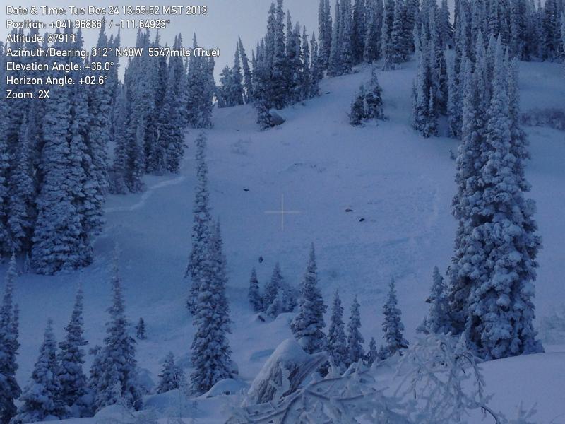
recent activity We found a good sized natural avalanche in Steep Hollow yesterday. The 2' deep by around 130' persistent slab avalanche was on a north facing slope at around 9000' in elevation and looks to have run overnight or late in the day 12-23-2013.
Here's a picture of the recent natural avalanche in Steep Hollow. (photo from 12-24-2013)
|
| type | aspect/elevation | characteristics |
|---|

|
|
LIKELIHOOD
 LIKELY
UNLIKELY
SIZE
 LARGE
SMALL
TREND
 INCREASING DANGER
SAME
DECREASING DANGER
|
|
description
The new snow from the last several days piled up and was drifted onto preexisting very weak sugary or faceted snow, which is widespread in the region. Dangerous human triggered avalanches failing in old weak faceted snow or in the basal layers of the existing snow pack remain likely in drifted terrain and in areas that picked up significant quantities of new snow. You could trigger persistent slab avalanches remotely or from a distance, and this could be an especially bad scene if you trigger one from below. Collapsing and/or shooting cracks are obvious red flags requiring you to reevaluate your route. Continue to avoid and stay out from under steep slopes, slopes connected to steep slopes, and obvious or historic avalanche paths.
|
| type | aspect/elevation | characteristics |
|---|

|
|
LIKELIHOOD
LIKELY
UNLIKELY
SIZE
 LARGE
SMALL
TREND
 INCREASING DANGER
SAME
DECREASING DANGER
|
|
description
Drifting of the fresh new snow caused the development of wind slabs, in many cases on top of very week preexisting snow. Dangerous conditions exist in exposed upper and mid-elevation terrain. Triggered wind slab avalanches are likely on steep slopes with significant recent deposits of drifted snow. You'll find wind slabs composed of stiffer snow in exposed lee slope terrain, especially in and around terrain features like gullies, scoops, sub-ridges, rock outcroppings, and cliff bands. We recommend that you continue to avoid travel in all steep drifted terrain. |
 |
weather Looks like it'll be sunny and nice in the mountains on Christmas Day! Expect 8500' high temperatures around 29 degrees and light to moderate northwest wind. It'll be mostly clear overnight, with mountain temperatures dropping into the mid-teens and moderate west wind. A high pressure system will move in overhead and take full control of the weather for at least the next few days, with fair and mild weather in the mountains and thickening valley inversions... Check out our one stop weather page........HERE |
| general announcements The Utah Avalanche Center wishes you a safe and powder-filled holiday season. Please consider the UAC in your holiday giving plans - your donations pay for these advisories and we can't do this without your help. What is it worth to you every day to get an avalanche and mountain weather advisory? The cost of a beverage or the gas it takes to get up the canyon? You can donate here. Utah Avalanche Center mobile app - Get your advisory on your iPhone along with great navigation and rescue tools. Discount lift tickets are now available at Backcountry.com - Thanks to Ski Utah and the Utah Resorts, including Beaver Mountain. All proceeds go towards paying for Utah Avalanche Center avalanche and mountain weather advisories. Benefit the Utah Avalanche Center when you shop from Backcountry.com or REI: Click this link for Backcountry.com or this link to REI, shop, and they will donate a percent of your purchase price to the UAC. Both offer free shipping (with some conditions) so this costs you nothing! Benefit the Utah Avalanche Center when you buy or sell on ebay - set the Utah Avalanche Center as a favorite non-profit in your ebay account here and click on ebay gives when you buy or sell. You can choose to have your seller fees donated to the UAC, which doesn't cost you a penny. Remember your information can save lives. If you see anything we should know about, please participate in the creation of our own community avalanche advisory by submitting snow and avalanche conditions. You can also call us at 801-524-5304 or 800-662-4140, email by clicking HERE, or include #utavy in your tweet or Instagram. Sign up early for one of our life-saving avalanche classes.......HERE And refresh your avalanche knowledge, check out some of our tutorials........HERE Follow us at UAClogan on Twitter I'll issue these advisories on Monday, Wednesday, Friday, and Saturday mornings. This advisory is produced by the U.S.D.A. Forest Service, which is solely responsible for its content. It describes only general avalanche conditions and local variations always exist. |


_1.jpg)