


Forecast for the Uintas Area Mountains

Issued by Craig Gordon on
Thursday morning, December 29, 2022
Thursday morning, December 29, 2022
There's no reason to mess around with this one... any avalanche that breaks to weak, sugary, midpack snow will be deep and dangerous -
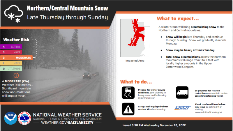
HIGH avalanche danger is found on all steep, mid and upper elevation slopes around the compass. The danger is most pronounced in the wind zone at and above treeline, in terrain facing the north half of the compass, particularly on slopes with an easterly component to their aspect. Human triggered avalanches are VERY LIKELY. Don't get surprised... low elevation terrain is a player as well and you'll find CONSIDERABLE avalanche danger with human triggered avalanches LIKELY on steep, shady slopes. Lower elevation south facing terrain that had little or no snow snow prior to the big midweek storm offer MODERATE avalanche danger and human triggered avalanches are possible on steep slopes.
Where to ride today? You can have a blast carving deep trenches or meadow skipping in big open terrain with no overhead hazard, simply meaning... no steep slopes above or adjacent to where you're riding.

Low
Moderate
Considerable
High
Extreme
Learn how to read the forecast here
 Special Announcements
Didn’t get what you want for Christmas? Do your loved ones simply give you money for the holidays and say “Go buy something for yourself?” Support the UAC and get a great gift for yourself or your loved one at our Holiday Auction. The auction closes at 8:00 PM MT on January 2, 2023
 Weather and Snow
Nowcast- On last gasp out of our midweek Atmospheric River delivers a trace or perhaps several traces of snow overnight, adding to the already colossal snow numbers. Trial Lake is the big winner, stacking up 24" of snow with 2" of H2O while upper elevation zones on either side of Mirror Lake Highway clock in at a solid 18" of snow. Under partly cloudy skies temperatures begin a crisp work day in the single digits and low teens, whilst west and northwest winds blow 20-30 mph along the high ridges. Riding and conditions are all-time and yes... it's over-the-head and over-the-hood yo :)
Forecast- Get it while you can! A break in the action delivers a beautiful day with partly cloudy skies and temperatures climbing into the low 20's. West and northwest winds decrease as the day wares on, while clouds thicken late in the day ahead of our next series of storms.
Futurecast- A multi-day storm begins Friday and homesteads through the weekend. Snow develops late Friday morning, temperatures rise, and strong southwest winds develop Friday night into Saturday. While there's still a bit of uncertainty with timing, the bottom line is... big water, big wind, big snow!
Lots of excellent trip reports and recent obs are found HERE.
 Recent Avalanches
No significant avalanche activity since Christmas Eve, but the writing is on the wall. Both human triggered and natural avalanches display similar characteristics, revealing a failure in the midpack weakness which leads to avalanches gouging to the ground.
Recent avy activity and a slew of Uinta obs are HERE.

Avalanche Problem #1
Persistent Weak Layer
Type
Location
Likelihood
Size
Description
It's deceptively tricky today, avalanche avoidance is key, and here's why-
It'll be easy to think the fresh storm snow is the only avalanche game in town. But here's the deal... a very real and very dangerous avalanche dragon lurks deeper in our snowpack, but is concealed by all of Tuesday nights, light, fluffy snow. Now the curve ball... the snow underneath our skis, board, or track feels strong and bomber. But the rubber hits the road where strong snow rests on weaker snow, now buried deeply in the mid portion of our snowpack. The wild card in the entire deck is... the most likely place to trigger an avalanche is where the snowpack is slightly shallower, like lower down on the slope. The tricky party here is that once you knock the legs out from underneath and the avalanche breaks to the sugary, midpack persistent weak layer, the entire roof hanging above us... is gonna crash down on top of us! Avoid this setup and you avoid the avalanche dragon that will instantly ruin our day.
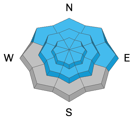
Avalanche Problem #2
Wind Drifted Snow
Type
Location
Likelihood
Size
Description
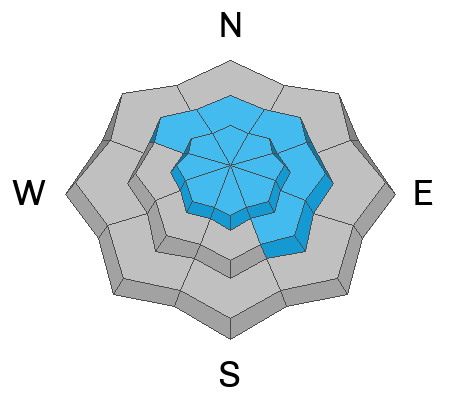
A 24 hour data dump from Windy Peak (10,661') illustrates where you're most likely to find a fresh, sensitive fresh drift.
Since Monday, winds have been all over the map. With no shortage of snow available to blow around, both new and older wind drifts are gonna react to our additional weight. It's not quite as cut and dry as it seems because once initiated, a seemingly manageable wind drift may break to weaker layers of snow buried deeper in the snowpack, producing an avalanche that quickly gets out of hand. The key to riding safely is simply avoiding fat rounded pillows of snow, especially if they're sounding hollow like a drum.
Additional Information
Weather stations-
And... we were super busy this summer upgrading the western Uinta weather station network and this real-time winter info is found HERE (click weather stations, and then on the Western Uinta tab)
Observations-
Your observations are important, so please let me know what you're seeing... click HERE and contribute to this amazing community-based program
General Announcements
Issued at 03:42 on Thursday December 29th, this forecast expires 24 hours after the date and time posted, but will be updated by 07:00 Friday December 30th.
Before it gets too crazy, now is the time to book an avalanche awareness presentation for your group, club, or posse. You can reach Craig directly at 801-231-2170 or [email protected].
This forecast is from the U.S.D.A. Forest Service, which is solely responsible for its content. This forecast describes general avalanche conditions and local variations always occur.