

Forecast for the Uintas Area Mountains

Issued by Craig Gordon on
Sunday morning, January 1, 2023
Sunday morning, January 1, 2023
Our snowpack is up against the ropes and teeters on the edge, especially on the south half of the range from Currant Creek to Daniels, just waiting for a trigger like us to tip the balance and knock the legs out from underneath-
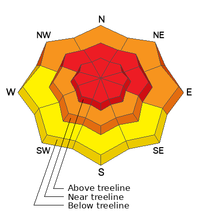
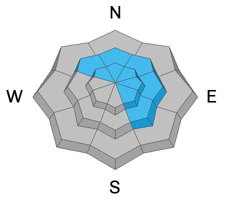
HIGH avalanche danger is found on all steep, mid and upper elevation slopes. The danger is most pronounced in the wind zone at and above treeline, in terrain facing the north half of the compass, particularly on slopes with an easterly component to their aspect. Human triggered avalanches are VERY LIKELY. Don't get surprised... low elevation terrain is a player as well and you'll find CONSIDERABLE avalanche danger with human triggered avalanches LIKELY on steep, shady slopes. Lower elevation south facing terrain that had little or no snow snow prior to the big midweek storm offer MODERATE avalanche danger and human triggered avalanches are possible on steep slopes.
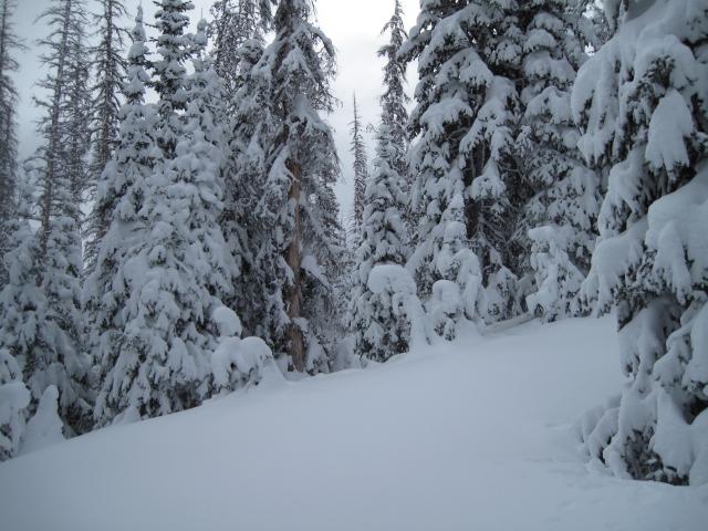
Where to ride today? You can have a blast carving deep trenches or meadow skipping in big open terrain with no overhead hazard, simply meaning... no steep slopes above or adjacent to where you're riding.
Low
Moderate
Considerable
High
Extreme
Learn how to read the forecast here
Avalanche Warning
The avalanche danger is HIGH and an AVALANCHE WARNING is in effect from 6AM MST this morning to 6 AM MST Monday for the mountains of northern Utah and southeast Idaho.
This AVALANCHE WARNING includes the Wasatch Range, Bear River Range, Uinta Range, and the Manti-Skyline Plateau.
Very dangerous avalanche conditions exist. With heavy snowfall and strong winds, both human-triggered and natural avalanches are likely. Please stay off of and out from under slopes steeper than 30 degrees.
 Special Announcements
Didn’t get what you want for Christmas? Do your loved ones simply give you money for the holidays and say “Go buy something for yourself?” Support the UAC and get a great gift for yourself or your loved one at our Holiday Auction. The auction closes at 8:00 PM MT on January 2, 2023
 Weather and Snow
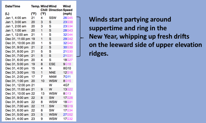
Nowcast- The Uinta's ring in the New Year under thick clouds with scattered snow showers while temperatures register in the low to mid 20's. Yesterday's storm took the scenic route through Provo Canyon, gracing the south half of the range with 18" of snow and just over 2" of H2O. For the North Slope and Mirror Lake zone, totals are a bit underwhelming, though a respectable 12" of snow with 1.5" H2O stacked up in the past 24 hours. Southerly winds were well-behaved until supper time when they ramped up for a New Years party with hourly averages in the 20's and gusts in the 40's near the high peaks. Recent winds patted down the fresh snow in our big open slopes, but lose a little elevation, seek out wind sheltered terrain, and you'll be greeted with outstanding riding and turning conditions on a go-anywhere base.
Forecast- Look for scattered snow showers with an additional 6" of snow stacking up throughout the day. Southwest winds blow in the 30's along the high ridges, but decrease as the day wares on. High temperatures climb into the low 30's with overnight lows dipping into the teens.
Futurecast- Hit or miss snow showers for Monday and Tuesday with a storm developing midweek.
Pasted! Ted was in the Gold Hill zone and reports a phat, white, North Slope. His most excellent writeup and insight are found HERE.
Meanwhile, Micheal J stomped around lower Weber Canyon and has a great report HERE.
Lots of excellent trip reports and recent obs are found HERE.
 Recent Avalanches
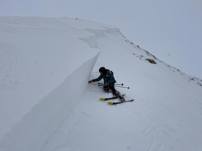
A thump delivered in the right spot on a steep northeast facing slope at 9,800' in Upper Weber Canyon yesterday, produces a sizable slide breaking 4' deep x 300' wide and 700' vertical. Snow-pro extraordinaire, Andy Nassetta shown here on the bed surface, confirms this avalanche failed on the Nov. facets (PWL) and clearly illustrates the size and scope of our current avalanche problem.
Additional avy activity and a slew of Uinta obs are HERE.

Avalanche Problem #1
Persistent Weak Layer
Type
Location
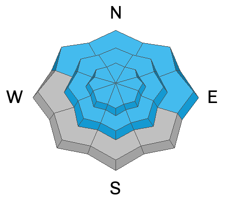
Likelihood
Size
Description
Snowpit profiles, stability tests, and the biggest clue to avalanches... avalanches, all reveal the mid pack PWL is guilty until proven otherwise.
Avalanche conditions are deceptively tricky and here's why-
I don't think we'll see widespread natural avalanche activity today and that's what makes our setup so dangerous right now. The hazard won't be in yer face. Persistent weak layers (PWL) just like we're dealing with right now, need a little provocation like us to roll along and kick the legs out from underneath. Often it's where the slab is thinner and that's the spot we can collapse the slope and irritate the weak layer. In fact, a common theme with this type of avalanche dragon are slides triggered lower downslope than you might expect. And we all know... that's a super dangerous setup, because once the avalanche is initiated, the entire roof crashes down on us. With all the great low angle riding available, there's no reason to pull on the avalanche dragons tail.
Avalanche Problem #2
Wind Drifted Snow
Type
Location
Likelihood
Size
Description
Data dump from Lofty Lake Peak (10,662') lays out the timeline for the evolution of overnight winds.
Winds are always the great equalizer for the eastern front and there's no shortage of snow available to blow around and form fresh drifts sensitive to our additional weight. Here's where it gets tricky because once initiated, a seemingly manageable wind drift may break to weaker layers of snow buried deeper in the snowpack as it crashes down onto the slope below, producing an avalanche that quickly gets out of hand. Lose the wind and you lose the problem. The key to riding safely is simply avoiding fat rounded pillows of snow, especially if they're sounding hollow like a drum.
Additional Information
Weather stations-
And... we were super busy this summer upgrading the western Uinta weather station network and this real-time winter info is found HERE (click weather stations, and then on the Western Uinta tab)
Observations-
Your observations are important, so please let me know what you're seeing... click HERE and contribute to this amazing community-based program
General Announcements
Please join me Wednesday Jan. 4th at 5:30 and we'll discuss what's going on with our snowpack, our avy danger, and how we can move around in the backcountry safely.
Issued at 04:01 on Sunday January1st, this forecast expires 24 hours after the date and time posted, but will be updated by 07:00 Monday January 2nd, 2023.
Before it gets too crazy, now is the time to book an avalanche awareness presentation for your group, club, or posse. You can reach Craig directly at 801-231-2170 or [email protected].
This forecast is from the U.S.D.A. Forest Service, which is solely responsible for its content. This forecast describes general avalanche conditions and local variations always occur.