


Forecast for the Skyline Area Mountains

Issued by Brett Kobernik on
Tuesday morning, April 1, 2025
Tuesday morning, April 1, 2025
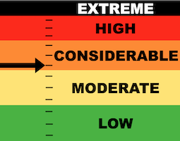
The new snow has bumped the avalanche danger rating up to MODERATE in most of the mid and upper elevations.
The new snow may be sensitive this morning. Watch for cracking within the new snow and use small steep test slopes to see if the new snow wants to move. In the absence of any cracking, the new snow is most likely stable.
There is still a minor chance of triggering an avalanche that breaks deep into older sugary weak snow. The danger rating is CONSIDERABLE on very steep slopes that face north, northeast and east.

Low
Moderate
Considerable
High
Extreme
Learn how to read the forecast here
 Weather and Snow
Current Conditions: A cold front moved through last night and has produced about 6 to 10 inches of snow so far. Wind picked up speed and is a bit stiff along the higher terrain. Temperatures dropped to around 20˚F overnight. The new snow should be "right side up".
Mountain Weather: It's snowing steady as of 7am but will become more spotty as the day goes on. We may see 2 to 4 inches more snow today. Temperatures will remain fairly cold and the wind from the west northwest looks pretty breezy through the day. The weather remains unsettled into the weekend with chances for small snow accumulations over the next few days.

Avalanche Problem #1
New Snow
Type
Location
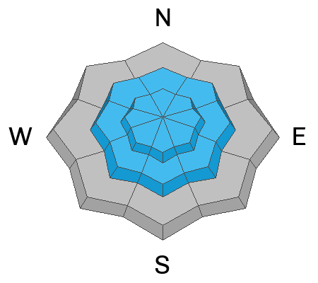
Likelihood
Size
Description
Sometimes new snow is stable, sometimes it is sensitive and wants to move. My hunch is today's snow is going to be stable. It came in "right side up" instead of being inverted. However, there was some wind during the storm which may have created some sensitive drifts.
Overall, the new snow avalanche problem is a fairly simple one to deal with:
- Look for recent avalanches.
- Watch for cracking within the new snow as you travel.
- Use steep but small test slopes to see if you can get the snow to move.
If you are not seeing any of the criteria above, the new snow is most likely stable and won't pose much threat. If you are seeing those red flags, just back off the slope angles and stick to lower angled terrain.
Avalanche Problem #2
Persistent Weak Layer
Type
Location
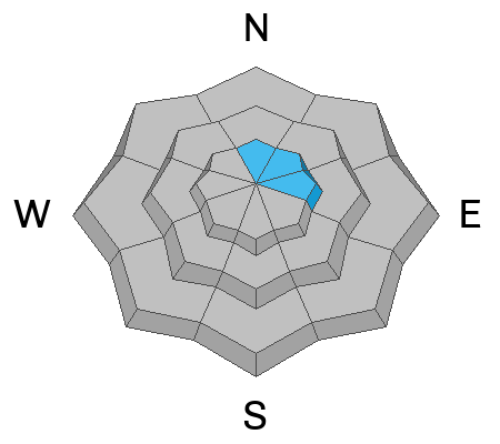
Likelihood
Size
Description
Triggering an avalanche that breaks deep into old layers of sugary faceted snow remains the most serious threat out there today. On the bright side, the chances for doing this seem to becoming pretty unlikely. Warm temperatures over the last week certainly helped stabilize the snowpack. Is it totally stable? I'm not trusting it.
General Announcements
This forecast is from the U.S.D.A. Forest Service, which is solely responsible for its content. This forecast describes general avalanche conditions and local variations always occur.