


Forecast for the Skyline Area Mountains

Issued by Brett Kobernik on
Sunday morning, March 30, 2025
Sunday morning, March 30, 2025
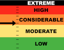
The majority of the terrain on the Skyline has a LOW to MODERATE avalanche danger.
There is still a minor chance of triggering an avalanche that breaks deep into older sugary weak snow. The danger rating is CONSIDERABLE on very steep slopes that face north, northeast and east.
Chances of triggering something continue to become less but consequences remain serious.

Low
Moderate
Considerable
High
Extreme
Learn how to read the forecast here
 Weather and Snow
Current Conditions: Cooler temperatures and some cloud cover kept the snow firm on Saturday. A storm system moved in late in the day and produced 2 to 4 inches of new snow. Wind speeds increased from the southwest during the storm event. The new snow will soften the riding conditions slightly but won't be much of an improvement.
Mountain Weather: We should see mostly cloudy skies today with temperatures into the mid 30s. Wind from the southwest should be light this morning and perhaps increasing slightly late this afternoon. Another system will move through Monday into Tuesday that looks a little more impressive than this past one. I'm currently thinking around 10" of new snow might fall.

Avalanche Problem #1
Persistent Weak Layer
Type
Location

Likelihood
Size
Description
The new snow won't change the avalanche danger much. Triggering an avalanche that breaks deep into old layers of sugary faceted snow remains the most serious threat out there today. Chances become less and less as the spring progresses. The last warm up really melted the snow a bunch and now it is frozen up again. This melt-freeze cycle should continue to stabilize those old weak layers. All that said, just keep in mind, there is still a chance to trigger a dangerous avalanche and there's no good way to determine which slope will release and which one won't.
General Announcements
This forecast is from the U.S.D.A. Forest Service, which is solely responsible for its content. This forecast describes general avalanche conditions and local variations always occur.