UDOT PLANNED AVALANCHE CLOSURES!!

Forecast for the Uintas Area Mountains

Craig Gordon
Issued by Craig Gordon on
Saturday morning, January 13, 2024
Make no mistake.... this is the real deal and the personality of our avalanche dragon is unpredictable, unruly, unmanageable, and once triggered.... unsurvivable.
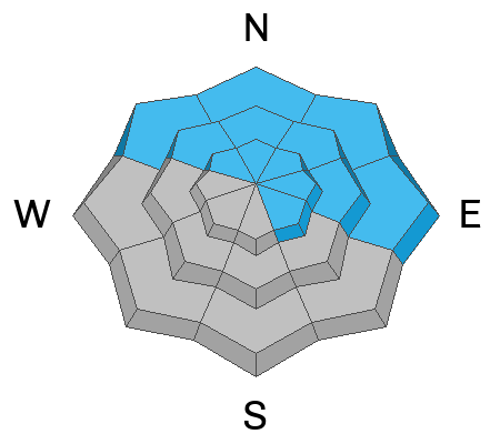
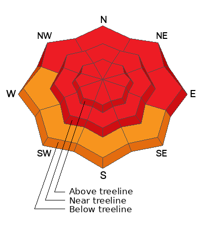
Recent winds coupled with heavy snow deliver a knock out punch and the avy danger is HIGH at all elevations on slopes facing the north half of the compass. Both human triggered and natural avalanches are VERY LIKELY. Any avalanche triggered in steep, leeward terrain at and above treeline, especially in the wind zone on slopes with an easterly component to its aspect has the potential to deliver a devastating avalanche.
CONSIDERABLE avalanche danger exists on south aspects near lower elevation trailheads where fresh storm snow reacts to our additional weight and human triggered avalanches are LIKELY.

Here's your exit strategy-
I know you're looking for a place to ride, but it's time to really rein it in. Big, open, low elevation meadows with NO overhead hazard (no steep slopes above or adjacent to where you're riding) are the ticket. Remember, the snowpack is in its infancy and it's still lean with no shortage of equipment trashing rocks and stumps barely lurking underneath a thin coat of white paint.
Low
Moderate
Considerable
High
Extreme
Learn how to read the forecast here
Avalanche Warning
An AVALANCHE WARNING is in effect from 6am MST this morning to 6am MST Sunday, for the mountains of northern and central Utah, including the Wasatch Range...Bear River Range...Uinta Mountains...and Manti-Skyline plateau.
The avalanche danger is HIGH. Both human triggered and natural avalanches are VERY LIKELY.
Strong winds and heavy snowfall have created dangerous avalanche conditions. Avalanches failing on a widespread persistent weak layer buried under the new snow are likely. Please stay off of and out from under slopes steeper than 30°.
Special Announcements
Please, Sign up for forecast region-specific text message alerts about changing avalanche conditions, watches, and warnings.
Weather and Snow
Nowcast- Holy cow... tipping winds! Starting right out of the gates yesterday morning and ramping up through the day, winds blowing from the west and southwest nuked in the 60's and 70's with gusts to nearly 100 mph near the high peaks. Snow blew sideways and it's tough to tell exactly how much storm snow stacked up, but I'm gonna hedge my bets and say 24 hour totals are right around 14" with just over an inch of H2O. Temperatures hover in the low single digits. You'll need to seek out very sheltered terrain today to find snow that hasn't been wind-jacked.
Forecast- Mostly cloudy skies with scattered snow showers this morning. West and southwest winds crank in the 50's and 60's and temperatures climb into the mid 20's. Hardly a break in the action before the next system nails us late today, bring very heavy snow and strong winds.
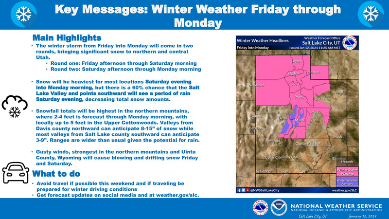
Futurecast- A piece of atmospheric river jumps on the storm train tonight and tomorrow. I think the Uintas get clobbered... meaning big snow and big water. Potentially 3" of SWE and 30" of snow by the time the storm winds down late Monday.
The image above ties in with a Winter Storm Warning for the Uinta zone.

Recent Avalanches
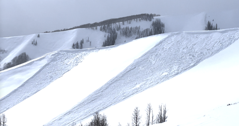
Lower elevation and super connected, this slide mostly likely failed on a layer of buried surface hoar and could easily bury a person in the creek-bed (terrain trap) below.
Shaun Raskin commented on a recent slide with the same characteristics near Hwy. 35 just above Soapstone Pass.
More Uinta avy activity found HERE

Latest Uinta observations are found HERE.
Ad
Avalanche Problem #1
Persistent Weak Layer
Type
Location
Likelihood
Size
Description
Make no mistake.... this is the real deal and the personality of our avalanche dragon is unpredictable, unruly, unmanageable, and once triggered.... unsurvivable.
It's game on, it's tricky out there, and it's getting downright rowdy. In fact, slabs triggered from a distance are becoming the rule more than the exception.
Here's the setup... a strong cohesive slab rests on a Gong Show of weak, old, sugary snow, or in snow-geek-speak... a persistent weak layer (PWL) formed during the December dryspell. Whatever your classification, know that once triggered, any avalanche breaking into older snow will instantly ruin your day.
Here's what we do to keep it simple... it's time to pump the brakes and simply stay off of and out from under steep terrain.
Avalanche Problem #2
Wind Drifted Snow
Type
Location
Likelihood
Size
Description
Winds have been all over the map this week, blowing from nearly every quadrant of the compass and penetrating into lower elevation terrain. With no shortage of snow available for transport, fresh drifts sensitive to our additional weight have formed everywhere. Today, we need to look for and avoid fresh wind drifts on the leeward side of ridges and around terrain features like chutes and gullies. Any slide triggered will break deeper and wider than you might expect.

Additional Information
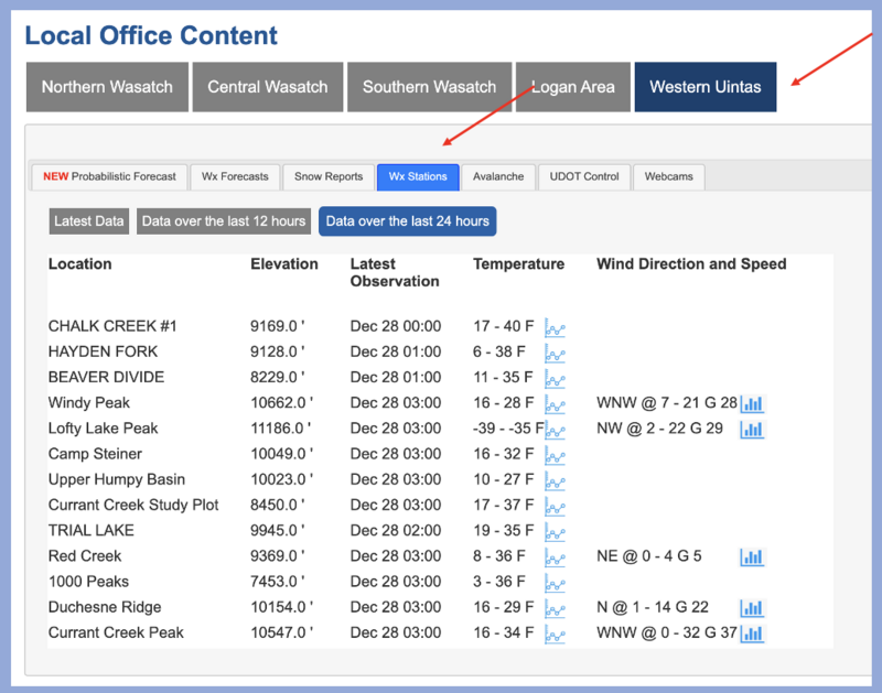
The Uinta weather station network was upgraded this summer and all that real-time info is found HERE. Simply click on "western Uinta" tab and then "weather stations" tab.

We are always looking for snow and avalanche observations or just general riding conditions. So... if you see something, say something. You can reach me directly at [email protected] or 801-231-2170.
Also, if you're looking for more avy education opportunities for yourself, your crew, or your club please don't hesitate to reach out to me and we'll find a presentation, class, or clinic for ya!
General Announcements

Issued at 0430 on Saturday, January 13th this forecast will be updated by 0700 Sunday, January 14th, 2024.
This forecast is from the U.S.D.A. Forest Service, which is solely responsible for its content. This forecast describes general avalanche conditions and local variations always occur.