Forecast for the Uintas Area Mountains

Mark Staples
Issued by Mark Staples for
Sunday, January 14, 2024
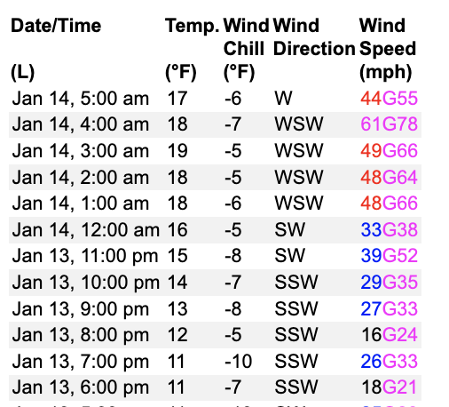
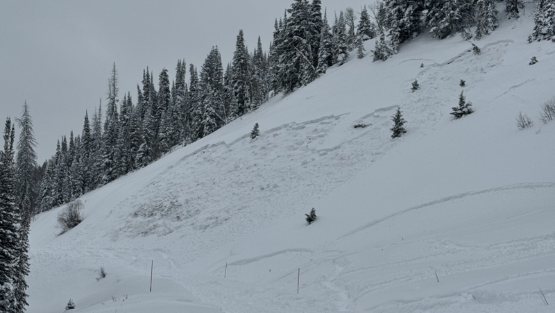
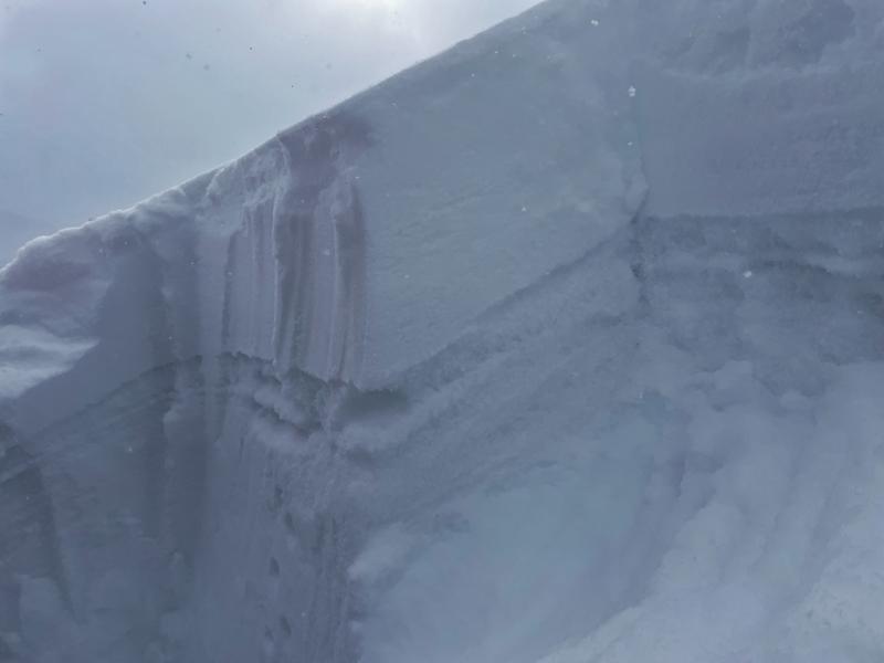
Avalanches are happening THIS MORNING across most of Utah and MORE WILL CRASH DOWN TODAY.
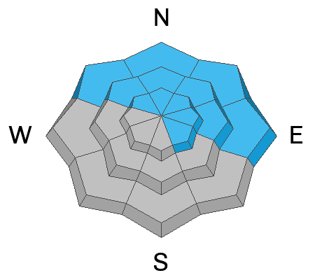
The avalanche danger is EXTREME on all slopes.
AVOID all avalanche terrain today. AVOID being anywhere near steep slopes.
Low
Moderate
Considerable
High
Extreme
Learn how to read the forecast here
Avalanche Warning
An AVALANCHE WARNING is in effect from 6am MST this morning to 6am MST Monday, For the mountains of northern and central Utah and southeast Idaho, which includes the Wasatch Range...the Bear River Range...Uinta Mountains...Manti-Skyline plateau...and the Mountains of Southwestern Utah.
The avalanche danger is EXTREME. Both human triggered and natural avalanches are VERY LIKELY.
Strong winds and heavy snowfall have created dangerous avalanche conditions. Avalanches failing on a widespread persistent weak layer buried under the new snow are very likely. Stay off of and out from under slopes steeper than 30°.
Weather and Snow
This morning it's snowing hard and winds are howling from the west (see wind speeds below from Windy Peak). It's hard to say how much snow has fallen because it is compressing as more snow falls. In terms of water, most places in the Uintas as of 0500 have received snow containing 0.8 inches of water in the last 24 hours (about 10-12" of snow). That snow has fallen on top of another inch of water and 14 inches of snow from the previous day. Temperatures this morning are hovering in the 20s F which is a big change from the last few days.
Snow is stacking up as I write and another 8-10" of snow should fall today with remnants of an atmospheric river overhead (think conveyor belt of moisture). Winds will ease a little bit and blow from the WNW at about 30 mph. Temperatures will drop about five degrees by this afternoon as cold air descends over northern Utah again.
There's tons of powder everywhere; however, much warmer temperatures and high precip rates this morning have likely created upside down snow - which is denser snow on top of lighter snow.
Recent Avalanches
Avalanches are happening this morning at all elevations. A great example of what to expect is an avalanche that happened yesterday in Mill Hollow just above the groomed road (photo below). Additionally, there were three snowmobilers buried in American Fork Canyon yesterday. One of them was fully buried several feet deep and had started turning blue before he was dug out by another group. It was a very close call, but all the riders were ok.
There were other avalanches reported in the Uintas and many more across Utah. In fact UDOT sensors in Little Cottonwood Canyon detected natural avalanches happening all night long. Snowcat drivers doing overnight grooming at resorts have reported slides everywhere.

Read more Uinta observations and avalanches HERE.
Ad
Avalanche Problem #1
Persistent Weak Layer
Type
Location
Likelihood
Size
Description
Slab avalanches will be happening on a layer of weak, sugary facets today at all elevations, mostly on north and east facing slopes. These slides will either happen naturally, or you can trigger them by simply going near a slope. These slides will occur on both sheltered slopes and wind loaded slopes.
The photo below from Strawberry Peak last week shows the weak layer except there's triple the amount snow on top of it now. This weak layer will allow avalanches to break over huge areas. It will allow you to trigger avalanches from flat terrain.
Avalanche Problem #2
New Snow
Type
Location
Likelihood
Size
Description
The new snow by itself will produce soft slab avalanches on all aspects and elevations. The weak layer can either be facets mentioned above or simply a layer of low density snow under this mornings slightly heavier snow. Strong westerly winds will only make avalanches larger and easier to trigger.
Additional Information
The Uinta weather station network was upgraded this summer and all that real-time info is found HERE. Simply click on "western Uinta" tab and then "weather stations" tab.

We are always looking for snow and avalanche observations or just general riding conditions. So... if you see something, say something. You can reach me directly at [email protected] or 801-231-2170.
Also, if you're looking for more avy education opportunities for yourself, your crew, or your club please don't hesitate to reach out to me and we'll find a presentation, class, or clinic for ya!
General Announcements

Issued at 0700 on Sunday, January 14th this forecast will be updated by 0700 Momday, January 15th, 2024.
This forecast is from the U.S.D.A. Forest Service, which is solely responsible for its content. This forecast describes general avalanche conditions and local variations always occur.