Forecast for the Uintas Area Mountains

Mark Staples
Issued by Mark Staples for
Monday, January 15, 2024
The avalanche danger today is HIGH on nearly all terrain. Both natural and human-triggered avalanches are likely.
Avoid being on, under, or near all avalanche terrain because slides will crash down on top of you.
Take advantage of all the rolling, gentle terrain less than 30 degrees in steepness in the Uintas but make sure to avoid being near any steeper slope. Even very small slopes will produce avalanches,
Low
Moderate
Considerable
High
Extreme
Learn how to read the forecast here
Avalanche Warning
An AVALANCHE WARNING is in effect from 6am MST this morning to 6am MST Tuesday, For the mountains of northern and central Utah and southeast Idaho, which includes the Wasatch Range...the Bear River Range...Uinta Mountains...Manti-Skyline plateau...and the Mountains of Southwestern Utah. The avalanche danger is HIGH. Both human triggered and natural avalanches are VERY LIKELY. Stay off of and out from under slopes steeper than 30°.
Weather and Snow
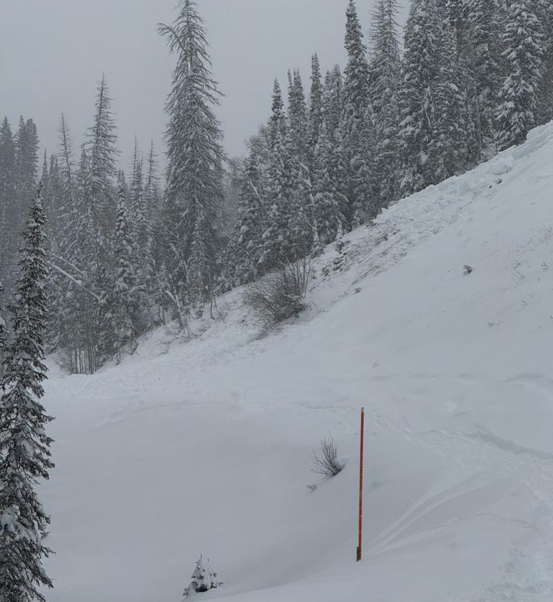
Since yesterday another 3-6 inches of snow fell (0.3-0.6" of water) favoring the northern half of the Uintas. This brought the three-day total to about 30 inches of snow (2-2.7" of water); however, many upper elevation areas received more than that amount but strong winds have made it hard to measure.
This morning it's still snowing but snowfall today shouldn't add up to more than an inch. 
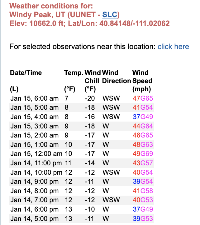
Winds are still ripping from the west at 45 mph gusting to 60 mph on the peaks. Temperatures are around 10 degrees F at upper elevations, mid teens F at mid elevations, and low 20s F at trailheads.
Today a cold front will brush by northern Utah and drop temperatures a few degrees. Dry air will fall behind the cold front and the sun may poke through the clouds late today. Strong winds continue this morning, and this afternoon they will blow from the NW at 20-30 mph at upper elevations. Some weather stations may be covered with rime ice and it's hard to get accurate readings this morning.
This week will have a brief ridge of high pressure (and sunshine) for Tuesday, another storm Wednesday (maybe 5" of snow), another ridge Thurs/Friday, and then a warm storm system (maybe another 5" of snow) for Sat/Sun.
The powder is deep and yesterday many people reported deep trail breaking and tough travel. Snowfall since Jan 4th has brought many SNOTEL sites back to average water amounts. Scroll to the bottom of the page for current snow depths.
Recent Avalanches
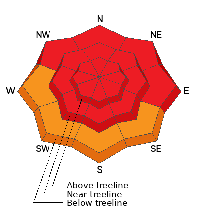
Avalanches happened all over Utah yesterday, and Little Cottonwood Canyon never opened due to avalanches. Because the weather was so bad, we don't know the full extent of avalanche activity in the Uintas. A steep slope above the Mill Hollow road avalanched on Saturday and then other parts of the slope released yesterday burying the road. Three snowmobilers were buried in American Fork Canyon on Saturday. One of them was fully buried several feet deep and had started turning blue before he was dug out by another group. It was a very close call, but all the riders were ok.
The general trend was widespread avalanche activity with many happening in places that rarely slide.
Photo: J Climaco

Read more Uinta observations and avalanches HERE.
Ad
Avalanche Problem #1
Persistent Weak Layer
Type
Location
Likelihood
Size
Description
Both soft slab and hard slab avalanches breaking on a persistent weak layer of facets are likely today. A layer of facets from December is buried about 3 feet deep (3.8-5.4" of water on top of it) that will be the mostly likely layer to produce slides. However, old November snow near the ground may also break and produce an even larger slide. Wind loaded slopes will break 4-6 feet or deeper and over huge areas.
You can trigger one of these slides by simply riding under or near any slope.
Avalanche Problem #2
Wind Drifted Snow
Type
Location
Likelihood
Size
Description
Winds have been ripping since Friday from a bunch of different directions and are blowing strong again this morning (see screen shot from Windy Peak below). Few areas near an above treeline haven't been affected. These hard slabs of wind drifted snow are a problem of their own, and they will also create large slides on the persistent weak layer described above.
Avalanche Problem #3
New Snow
Type
Location
Likelihood
Size
Description
There's simply a ton of new snow which can easily produce soft slab avalanches even on slopes lacking any wind effect or a persistent weak layer. Give the new snow time to settle and bond which will happen in the next day or two.
Additional Information
Snow summary from NRCS SNOTEL sites:
The Uinta weather station network was upgraded this summer and all that real-time info is found HERE. Simply click on "western Uinta" tab and then "weather stations" tab.

We are always looking for snow and avalanche observations or just general riding conditions. So... if you see something, say something. You can reach me directly at [email protected] or 801-231-2170.
Also, if you're looking for more avy education opportunities for yourself, your crew, or your club please don't hesitate to reach out to me and we'll find a presentation, class, or clinic for ya!
General Announcements

Issued at 0700 on Monday, January 15th this forecast will be updated by 0700 Tuesday, January 16th, 2024.
This forecast is from the U.S.D.A. Forest Service, which is solely responsible for its content. This forecast describes general avalanche conditions and local variations always occur.