Forecast for the Uintas Area Mountains

Craig Gordon
Issued by Craig Gordon for
Tuesday, January 16, 2024
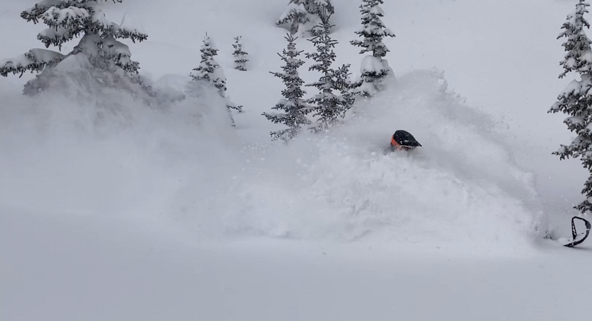
The combo of sunny skies and fresh snow will tug at our better judgment today. But make no mistake, because your life depends on it... these are the exact conditions when most avy fatalities occur-
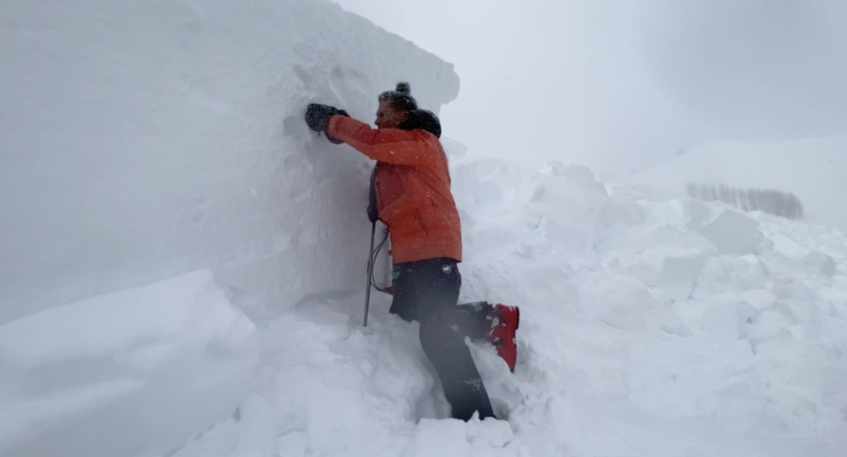
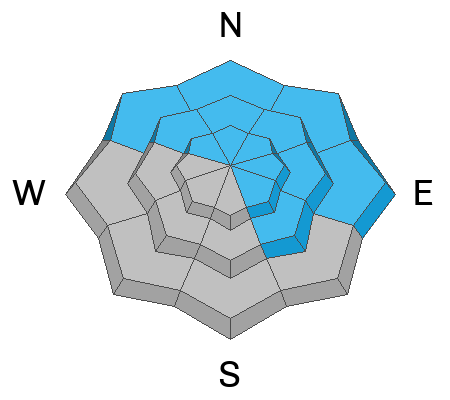
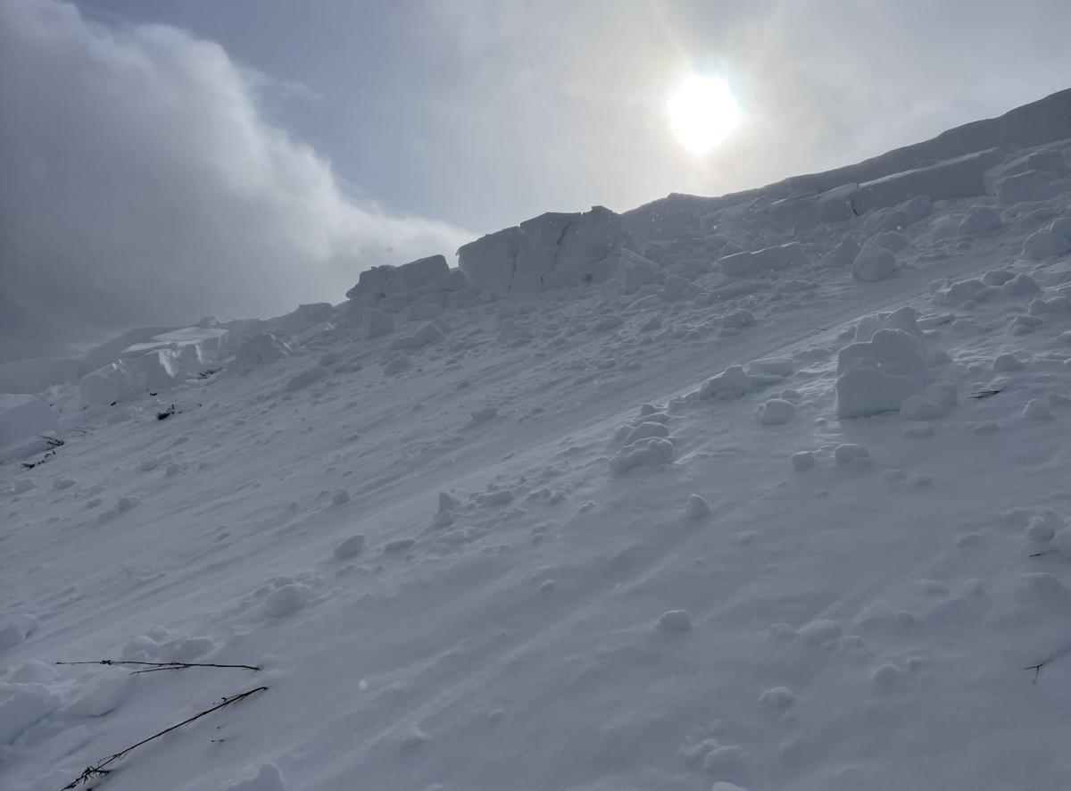
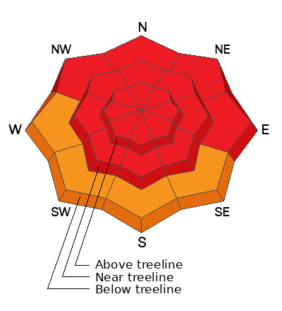
From tip to tail, HIGH avalanche danger is found on steep slopes around the compass, but it's particularly sketchy in the windzone at and above treeline. Human triggered avalanches breaking to deeply buried weak layers are LIKELY in terrain facing the north half of the compass, and especially on slopes with an easterly component to its aspect. Note to self... any avalanche triggered will result in a deep, dangerous, and potentially unsurvivable slide.
Lower elevation terrain facing the south half of the compass delivers CONSIDERABLE avalanche danger and human triggered avalanches are PROBABLE on steep, wind drifted slopes.

Here's your exit strategy-
Today we need to steer clear of overhead hazard and that means... avoid being on, under, or near all avalanche terrain where we could potentially pull the rug out from underneath and crash the roof down on top ourselves.
Low
Moderate
Considerable
High
Extreme
Learn how to read the forecast here
Special Avalanche Bulletin
A Special Avalanche Bulletin is in effect from 6am MST this morning to 6am MST Wednesday for all the mountains of northern, central and southern Utah, to include southeastern Idaho and the Bear River Range.
This of course includes the western Uintas where the avalanche danger is HIGH.
Dangerous avalanche conditions exist on many slopes of all elevations. Avalanche accidents often occur under these conditions. Please stay off of and out from underneath slopes steeper than 30 degrees
Weather and Snow
Nowcast- A break in the action overnight ushered in clearing skies and a blast of cold air, delivering temperatures that hover right around zero. Since last Friday, overachieving ridgetop winds have been working overtime and into a good portion of Monday, but decided to take a personal day, kick back and relax a little bit, and currently blow from the west, clocking in at 15-25 mph near the high peaks. It's been a superior run of storms and in less than a week our snowpack doubled, going from zero to hero. Yup, the riding and turning is all time right now.
Forecast- It'll be an amazing, yet crisp day in the mountains. Expect sunny skies, high temperatures climbing into the mid 20's, and westerly winds blowing 20-30 mph near the high peaks. Look for increasing clouds tonight with overnight lows in the teens.
Futurecast- Another round of storminess moves in from the west and northwest overnight, bringing a good shot of snow that initially benefits the south half of the range before the North Slope fires up. In either case ,Wednesday will be snowy with about a foot stacking up during the day. Snow tapers off Thursday with another break in the action slated for Friday. A warm, wet storm is expected to arrive this weekend and camps out into the middle of next week.

Pro rider extraordinaire and overall remarkable person, Dan Gardiner, enjoyed all our recent storm snow and did it safely by riding terrain with no steep slopes above or adjacent to where he was traveling. He got the goods, got home safely to his family, and somewhere in-between got plenty of time in the White Room :)
Three-day snow totals stack up to about 30" of snow with just over 2" of water. The bigger news are the Herculean totals on the northern half of the range since January 4th which clock in at 64" of snow and just over 5" of water.
Scroll to the bottom of the page for current snow depths.
Recent Avalanches
I can get barely get my hand into super dense snow at the crown face of this slide on an east facing slope at 9,300'. Resting on a thin layer of facets, this avalanche, triggered low on the slope yesterday, is the type of avalanche dragon we're dealing with right now.
Also... three snowmobilers were buried in American Fork Canyon on Saturday. One rider was fully buried several feet deep and had started turning blue before he was dug out by another group. It was a very close call, but at the end of the day, all the riders were ok.

Read more Uinta observations and avalanches HERE.
Ad
Avalanche Problem #1
Persistent Weak Layer
Type
Location
Likelihood
Size
Description
Both soft and hard slab avalanches, failing on a persistent weak layer now buried deep in our snowpack are likely today. Heads up, we can trigger a slide like in the image above, by simply riding under or near any steep slope.
The good news... last weeks storm lit up the Uintas, pasting the range with a thick coat of white paint, and our backyard looks like winter!
The bad news... big snow, big water, and big wind equals a tremendous amount of weight (stress) stacking up on our mid December drought layer. Indeed, the snowpack is up against the ropes and reeling from this body bruising trifecta.
Now for the flake news... just like a migrating school of white sharks this setup isn't going away quickly, so we need to go to the mountains on its terms, give the snowpack some time to adjust, and simply avoid the sharks habitat. Perhaps over time these visiting apex predators leave their feeding grounds and we can paddle out into the lineup. However, now is the time to pump the brakes, practice some patience, know it's a long season and we've got plenty more opportunities to ride fresh pow.
Avalanche Problem #2
Wind Drifted Snow
Type
Location
Likelihood
Size
Description
Above is the weekend data dump and wind run from Windy Peak (10,661') clearly illustrating our recent bout of hurricane force winds.
Winds from nearly every direction, started cranking last Friday and continued tipping cows through the weekend, penetrating terrain we usually consider sheltered. With no shortage of snow available to blow around you'll find hard, dense, wind drifts in unusual locations and lower down slope than we expect to see. A problem unto themselves no doubt, but once triggered, any new or older drift can break into deeper buried weak layers as it crashes down on the slope below, creating a much larger slide than you might've bargained for. The ticket is to avoid fat rounded pillows of snow, especially if they sound hollow like a drum.
Additional Information
Snow summary from NRCS SNOTEL sites:
The Uinta weather station network was upgraded this summer and all that real-time info is found HERE. Simply click on "western Uinta" tab and then "weather stations" tab.

We are always looking for snow and avalanche observations or just general riding conditions. So... if you see something, say something. You can reach me directly at [email protected] or 801-231-2170.
Also, if you're looking for more avy education opportunities for yourself, your crew, or your club please don't hesitate to reach out to me and we'll find a presentation, class, or clinic for ya!
General Announcements

Issued at 0430 on Tuesday, January 16th this forecast will be updated by 0700 Wednesday, January 17th, 2024.
This forecast is from the U.S.D.A. Forest Service, which is solely responsible for its content. This forecast describes general avalanche conditions and local variations always occur.