We have a lot of upcoming education and events -
- The 14th Annual Utah Snow and Avalanche Workshop is virtual again this year and will be held Nov 5th (professional session) and Nov 9th, 10th, 11th evenings from 6-9pm. More info and speaker lineup on our Events page HERE.
- Check all the upcoming education HERE.
If you're seeing anything we should know about, submit your observations
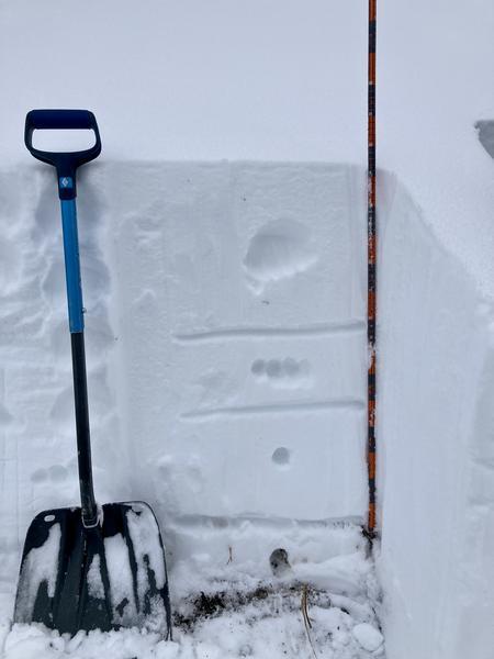
HERE.Currently: There is about 1-2' of dense, settled snow on shady slopes in the Cottonwoods and much of the southerly-facing aspects have melted out. Although warm temperatures may have taken a toll on what has been good riding conditions for October, the warm temperatures, dense snowfall, and roughly 18-24" snowpack has helped prevent weak snow from developing. McKinley Talty, the Know-Before-You-Go (KBYG) coordinator for the UAC,
was in Catherine's Pass area on Tuesday and found a strong and "rightside-up" snowpack:
This Weekend: A small system will move into the region on Saturday and should deliver a few inches of snow. Winds will be from the south and southwest and may gust into the 20's mph along ridges. Snowfall should diminish on Sunday with increasing southerly winds later Sunday and into Monday.
This Coming Week: A concern with October snow is that unless it keeps snowing, the existing snow on shady aspects will weaken and turn to facets and depth hoar, possibly creating a future weak layer into the winter. The best remedy to prevent a layer of "October Facets" is for continued snowfall and it looks like we'll get our wish (at least through midweek) as a stronger system enters our region on Monday. It should be quite windy and deliver 10-15" of snow by Wednesday morning with a rising avalanche danger likely.
History:
This active October weather reminds me of October 2004 where upper LCC received 122" between October 17th and Halloween. The Alta snow stake sat at a cool 81" on November 1st. But it was not all good news that year - the winter of 04/05 was our most tragic year for avalanche fatalities with eight.


