UDOT PLANNED AVALANCHE CLOSURES!!

Forecast for the Salt Lake Area Mountains

Greg Gagne
Issued by Greg Gagne on
Monday morning, January 6, 2020
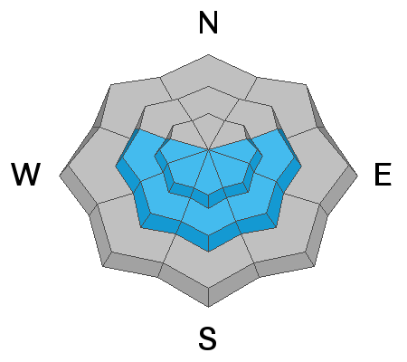
The avalanche danger is CONSIDERABLE on all upper elevation aspects where slabs of recent and fresh wind-drifted snow can be found. There is also a CONSIDERABLE hazard on southerly aspects at the upper elevations where avalanching may occur on a persistent weak layer of faceted snow around crusts. At the mid elevations there is a Moderate hazard for triggering wind slabs or avalanches failing around crusts on southerly aspects. Avalanches may break down 1-2' deep and well over 100' wide. Shallow, but long-running sluffs, may be possible in the new snow on steep slopes.
The hazard is Low at low elevations where avalanche conditions are generally safe.
Low
Moderate
Considerable
High
Extreme
Learn how to read the forecast here
Special Announcements
Get discount lift tickets HERE. Thanks for this generous support from Utah Ski Resorts and Ski Utah. All proceeds go directly to supporting the UAC.
New to the backcountry or in need of a refresher? Consider taking a companion rescue course offered at Woodward Park City, January 14, 5:30-9 p.m.
Weather and Snow
Currently, mountain temperatures range through the low to mid teens F, but moderate to strong westerly winds are making things feel much colder. Along upper elevation ridges, winds are averaging in the teens and 20's mph, with gusts in the 30's and 40's mph. At 11,000' averages are in the 40's and 50's, with gusts in the 60's mph.
Snowfall began mid-afternoon Sunday, but this storm ended up disappointing, with only 2-4" of snow reported by this morning. Fortunately, despite the low snowfall amounts, the fresh snow and winds smoothed out many snow surfaces providing fun riding and traveling conditions.
For today, you can expect clearing skies as the day progresses as high pressure moves into the region. Temperatures will reach the low to mid 20's F and winds will be out of the west/northwest. At mid-elevations winds will average in the teens with gusts in the 20's. Along upper elevation ridges winds will be much stronger, averaging in the 20's and 30's, with gusts in the 40's. Fortunately winds are forecasted to diminish as the day progresses.
Recent Avalanches
One backcountry avalanche was reported on Sunday. This was on a southeast aspect at 9400' on Wilson Peak. The slide was 12" deep and 175' wide, with a partial burial. Fortunately, a good outcome as the party was able to self-rescue. (Link to observation).
On Saturday, eight avalanches were reported from the backcountry, with two involving catching and carrying riders. Luckily no one was fully buried or injured in these slides. These avalanches were all roughly 1-2' deep and up to 100' wide. On Sunday Mark visited the site of Saturday's avalanche on Sunset Peak down into Dry Fork, and came across a second - unreported - avalanche in the same area. This avalanche also likely occurred on Saturday (observation).
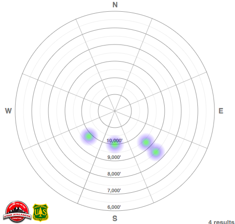
The heat map below illustrates the aspects and elevations of avalanche activity since Jan 1 in the Salt Lake mountains. What is interesting about these slides is that they are occurring on southerly aspects - the aspects we generally consider to be safer. More on this issue under the discussion of Persistent Weak Layer.
Make sure to check out all observations posted HERE.
Ad
Avalanche Problem #1
Wind Drifted Snow
Type
Location
Likelihood
Size
Description
Sustained winds the past several days have created wind drifts on a variety of aspects at the mid and upper elevations. This includes fresh drifts found near the surface, or drifts that formed this past weekend and are now buried underneath the snow surface.
Strong winds can work through terrain, depositing drifts on any aspect. Places where you can find fresh drifts include
- leeward aspects;
- open bowls;
- mid-slope rollovers;
- and cross-loading on gullies and other terrain features.
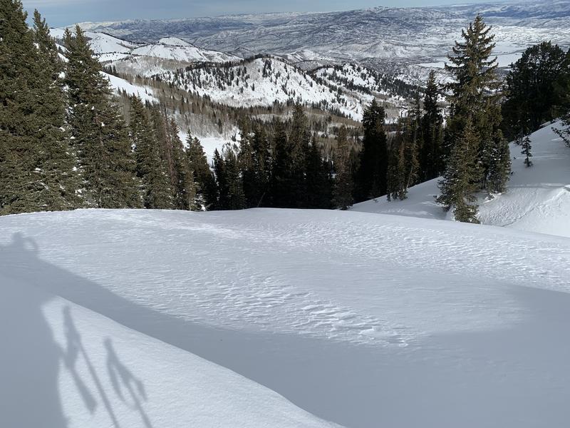
Wind-drifted snow can be easy to spot and avoid. It often looks round and pillowy, and it can sometimes feel hollow like a drum when you step onto a wind-loaded slope. [Pic: Paradis]
The best - and safest - riding conditions today will be on mid-elevation wind-protected slopes.
Avalanche Problem #2
Persistent Weak Layer
Type
Location
Likelihood
Size
Description
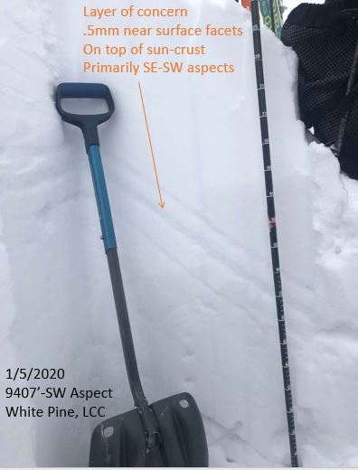
A combination of crusts surrounding a persistent weak layer of faceted snow exists on southerly aspects and is buried down 12-18". This weak structure has been the culprit for several human-triggered avalanches since the New Year, and the likely weak layer in Sunday's Wilson Peak avalanche. What is unusual is these avalanches are occurring on southerly aspects - precisely the aspects we generally consider to be safer. The photo below is from Nikki's field work on Sunday in White Pine (observation), illustrating this facet/crust structure:
In addition to recent avalanching (the most important red flag!), several field observations from Sunday indicate this layer is reactive with full propagation of extended column tests:
If you choose to ride south-facing slopes steeper than 30 degrees, you need to pull out your shovel and look for this facet/crust structure. Although it most likely exists on aspects facing southwest, south, and southeast, it may also be present on slopes facing east and west. I would personally avoid any slope where this weak structure exists.
Additional Information
What happened to the Persistent Weak Layer on northerly aspects that we've been discussing all season? Although this structure is still present and may come back to life in isolated areas at some point this season, for now, the problem is dormant.
General Announcements
This information does not apply to developed ski areas or highways where avalanche control is normally done. This forecast is from the U.S.D.A. Forest Service, which is solely responsible for its content. This forecast describes general avalanche conditions and local variations always occur.