Forecast for the Uintas Area Mountains

Craig Gordon
Issued by Craig Gordon for
Monday, April 3, 2023
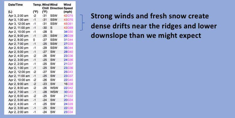
As today's storm evolves, expect strong winds and snow to tip the scales once again-
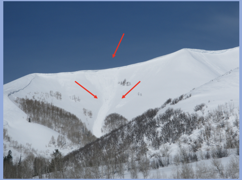
In the wind zone, above treeline, you'll find pockets of HIGH avalanche danger. Steep, rocky, upper elevation slopes, are particularly sketchy where both human triggered and natural avalanches are VERY LIKELY. Terrain facing the north half of the compass, especially steep slopes with an easterly component to its aspect have the potential to produce avalanches that'll pack a punch and could easily ruin your day. CONSIDERABLE avalanche danger is found near treeline and human triggered avalanches are LIKELY on steep slopes with recent deposits of wind drifted snow. Storm snow stacks up fast and furious and that'll deliver MODERATE, yet more predictable new snow issues on all steep slopes where human triggered avalanche are POSSIBLE.
Today's exit strategy- you can have a blast by simply heading to low angle, wind sheltered terrain with no overhead hazard.
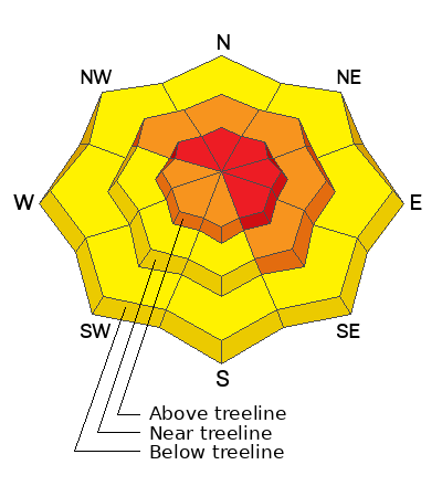
Low
Moderate
Considerable
High
Extreme
Learn how to read the forecast here
Weather and Snow
Nowcast- If you're checking in this morning hoping for lots of wind and very little snow.... I've got ya covered! The first in a two-part storm is beginning to slide into the region and just an inch of evenly distributed snow coats the range, but... southerly winds are blowing in the 30's and 40's along the ridges, gusting in the 70's near the peaks. We're still in the warm before the storm sector as temperatures hover near freezing at the trailheads and in the low to mid 20's near the ridges.
Forecast- Heavier snow begins right around sunrise and we'll see 6"-10" of snow stack up quickly. Temperatures fall into the teens as cold air settles into the area. Winds shift to the west and northwest and decrease somewhat, but they'll still be obnoxious, blowing in the 30's along the ridges.
Futurecast- Scattered snow lingers into Tuesday with a few more inches of snow piling up. Storm totals in the 18"-24" range seem reasonable before we begin drying out midweek.
Our good friends at the Salt Lake NWS issued a Winter Storm Warning for the western Uinta zone.
Big snow and big water deliver big views across the range, where I was honored to spread my dear friend, Nick Snyder's ashes on Saturday. A long time supporter of the UAC... Nicks loving spirit and peaceful heart will oversee our travels.
Trip Reports-
Ted was in the Whitney Zone Saturday and reports unreal coverage on a go anywhere base.
Detailed trip reports and recent obs are found HERE.
Recent Avalanches
Pieces of cornice peeled off the ridges late Friday, triggering shallow, yet very connected and long running avalanches on steep leeward slopes in the wind zone.
Ted also added an avy-savvy nugget and offers some sage insight from his travels... "There are so many different layers in the snowpack right now with old wind crusts, storm layers and some sun and heat crusts and it is challenging to keep track of all of them."
In addition, plenty of avy activity to peruse if ya wanna geek out. Click HERE to track this years slide activity throughout the range.
Ad
Avalanche Problem #1
Wind Drifted Snow
Type
Location
Likelihood
Size
Description
Not as excited as I am to start the workday or perhaps rollin' on Pacific Standard Time, Lofty Lake Peak (11,186') delivers super reliable wind data none-the-less.
Winds are the great equalizer for the eastern front and when combined with snow falling out of the sky, they're the game changer. As today's storm snow stacks up and winds crank, expect rapidly forming drifts on the leeward side of ridges and around terrain features like chutes and gullies. Once the storm kicks into gear, today's drifts may break deeper and wider than you might expect. And remember... today's storm is gonna stack a couple feet of snow on top of last weeks storm snow and there's an outside chance avalanches will break to a weaker layer of snow or density inversion, now buried deeply in our snowpack.
So... there's a bit of snowpack uncertainty going into the storm and the way we counter this is with terrain choices. In fact, there's plenty of terrain you can ride today and not have any issues. So for today, you can have a great day of riding by avoiding steep, wind drifted terrain and by steering clear of fat and rounded pieces of snow or slopes that sound hollow like a drum.

Avalanche Problem #2
New Snow
Type
Location
Likelihood
Size
Description
Storm snow piles up on a variety of snow surfaces, including hard, slick crusts. Once triggered, today's new snow avalanches have the potential to run faster and further than we might anticipate.
Additional Information
Weather stations-
And... rime events from January's atmospheric rivers severely crippled the Uinta weather station network. I'm working to get it back up and running, but a few stations are found HERE (click weather stations, and then on the Western Uinta tab)
Observations-
Your observations are important, so please let me know what you're seeing... click HERE and contribute to this amazing community-based program
General Announcements
Issued at 03:27 on Monday April 3rd this forecast expires 24 hours after the date and time posted, but will be updated by 07:00 Tuesday April 4th 2023.
Before it gets too crazy, now is the time to book an avalanche awareness presentation for your group, club, or posse. You can reach Craig directly at 801-231-2170 or [email protected].

This forecast is from the U.S.D.A. Forest Service, which is solely responsible for its content. This forecast describes general avalanche conditions and local variations always occur.