Forecast for the Uintas Area Mountains

Craig Gordon
Issued by Craig Gordon for
Tuesday, April 4, 2023
Today's avalanches are gonna run faster and further then you might expect and they'll be packing a punch-
In the wind zone, above treeline, you'll find HIGH avalanche danger around the dial. Steep, rocky, upper elevation slopes, are particularly sketchy where both human triggered and natural avalanches are VERY LIKELY. CONSIDERABLE avalanche danger is found near and below treeline (think terrain around our trailheads and foothills) where human triggered avalanches are LIKELY on steep slopes with recent deposits of wind drifted snow.
I know you wanna ride and avoid the avalanche dragon today and that's easy to do- you can have a blast by simply heading to low angle, wind sheltered terrain with no overhead hazard.

Low
Moderate
Considerable
High
Extreme
Learn how to read the forecast here
Avalanche Warning
An Avalanche Warning has been issued for the mountains of Northern Utah and Southeast Idaho including the Wasatch Range, Bear River Range, and Uinta Mountains.
The avalanche danger is HIGH today.
Recent heavy accumulations of snow and drifting have created widespread areas of unstable snow. Long running natural and human triggered avalanches are likely. People should avoid being in backcountry avalanche terrain, (off of and out from under slopes steeper than 30°), and stay clear of avalanche runouts.
Weather and Snow
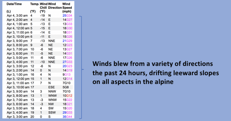
Nowcast- It's stomping! Our much anticipated storm was a little tardy to the powder party, but finally arrived fashionably late at o'dark thirty, delivering 12" of snow with just .60" H2O. Storm totals are a bit uneven... the North Slope through Mirror Lake stacked up 14"-18" of snow with just over an inch of water, while the south half of the range from Wolf Creek to Daniels registers 10" of snow with .50 H2O. In either case, it's uber-fluff, downright blower, and it's cold across the board with temperatures in the teens at the trailheads and single digits along the ridges. North and northeast winds blow in the 20's and 30's near the high peaks, creating a toe numbing windchill to -19 degrees. Riding and turning conditions are much improved, though the low density snow does little to cushion old, hard crusts and wind funk underfoot. Your best bet for a smooth ride are low angle, mid elevation, shady slopes.
Forecast- Scattered snow showers pile up a couple additional inches of snow, but I think the storm is winding down as the flow turns northeasterly. Temperatures don't vary much from where we're at this morning and are slow to crawl into the teens and low 20's. Northerly winds are gonna be a nuisance, blowing in the 30's near the high peaks.
Futurecast- A few lingering snow showers bring us to hump day and then our weather begins shifting towards a warmer, dryer pattern beginning mid week.
Big snow and big water deliver big views across the range, where I was honored to spread my dear friend, Nick Snyder's ashes on Saturday. A long time supporter of the UAC... Nicks loving heart, peaceful energy, and very generous spirit will oversee our travels on the eastern front.
Trip Reports-
Detailed trip reports and recent obs are found HERE.
Recent Avalanches
Not particularly shocking, long running sluffs and shallow soft slabs were Monday's avalanche flavor of the day. Today's slide have more volume and will pack a punch.
In addition, plenty of avy activity to peruse if ya wanna geek out. Click HERE to track this years slide activity throughout the range.
Ad
Avalanche Problem #1
Wind Drifted Snow
Type
Location
Likelihood
Size
Description
A 24 hour data dump from Windy Peak (10,661') illustrates where you're likely to find wind drifts sensitive to our additional weight.
With no shortage of low density snow available to blow around, expect to find both old and newly formed wind drifts on the leeward side of ridges and around terrain features like chutes and gullies. And remember... today's storm snow is stacking up on several weeks worth of storm snow and there's an outside chance avalanches will break deeper and wider than you might expect, perhaps failing on a weaker layer or density inversion, now buried deeply in our snowpack. In either case, once triggered they'll easily boss you around. The good news is... there's plenty of terrain you can ride today and not have any issues. In fact, you can have a great day of riding by avoiding steep, wind drifted terrain and by steering clear of fat and rounded pieces of snow or slopes that sound hollow like a drum. Done, done, and done :)

Avalanche Problem #2
New Snow
Type
Location
Likelihood
Size
Description
Storm snow piles up on a variety of snow surfaces, including hard, slick crusts. Once triggered, today's new snow avalanches have the potential to run faster and further than we might anticipate.
Additional Information
Weather stations-
And... rime events from January's atmospheric rivers severely crippled the Uinta weather station network. I'm working to get it back up and running, but a few stations are found HERE (click weather stations, and then on the Western Uinta tab)
Observations-
Your observations are important, so please let me know what you're seeing... click HERE and contribute to this amazing community-based program
General Announcements
Issued at 03:27 on Tuesday April 4th this forecast expires 24 hours after the date and time posted, but will be updated by 07:00 Wednesday April 5th 2023.
Before it gets too crazy, now is the time to book an avalanche awareness presentation for your group, club, or posse. You can reach Craig directly at 801-231-2170 or [email protected].

This forecast is from the U.S.D.A. Forest Service, which is solely responsible for its content. This forecast describes general avalanche conditions and local variations always occur.