Forecast for the Uintas Area Mountains

Craig Gordon
Issued by Craig Gordon for
Wednesday, March 6, 2024
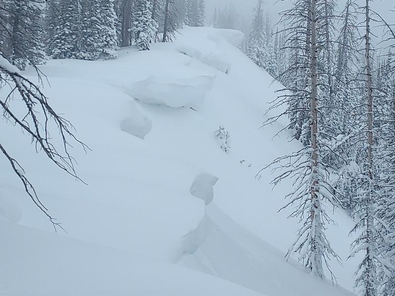
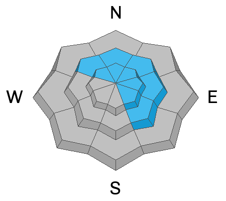
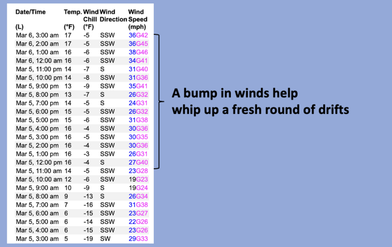
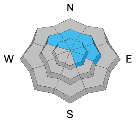
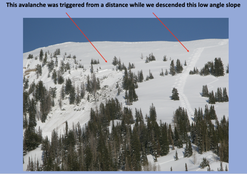
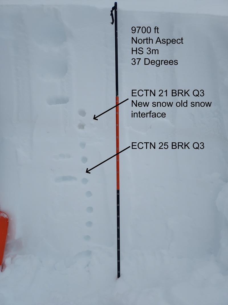
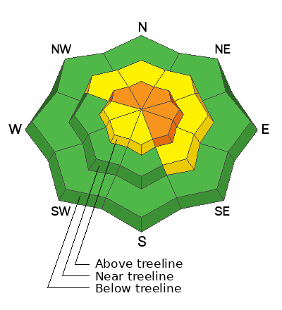
Not widespread and pockety in nature, you'll find CONSIDERABLE avalanche danger on wind drifted slopes at and above treeline. Human triggered avalanches are LIKELY especially on steep, leeward slopes, and particularly those with an easterly component to their aspect. In addition... while becoming more the exception than the rule, steep, rocky, slopes with a shallow snowpack is bulls-eye terrain where you can still trigger an avalanche that breaks to old snow near the ground.
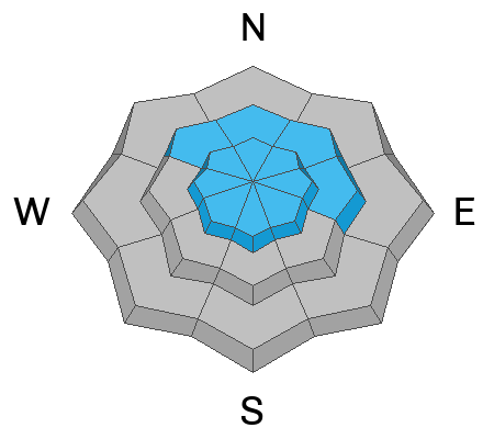
MODERATE avalanche danger exists near treeline on slopes facing the north half of the compass, where recent winds swirl and penetrate mid elevation terrain. Human triggered avalanches are POSSIBLE on steep slopes with recent deposits of wind drifted snow.
LOW avalanche danger is found below treeline on shady slopes along with mid and lower elevation terrain facing the south half of the compass.

Low
Moderate
Considerable
High
Extreme
Learn how to read the forecast here
Special Announcements
We are seeking a passionate individual to join us as Executive Director of the nonprofit Utah Avalanche Center. Click here for more information.
Weather and Snow
Nowcast- A band of thickening clouds drifts into the Uinta region early this morning and scattered snow showers are at our doorstep. Winds blowing from the south and southwest bumped into the 30's and 40's late last night and continue humming along the ridges at similar velocities at o'dark thirty. Meanwhile, temperatures held steady overnight, are about 10 degrees warmer than yesterday at this time, and register in the teens and low 20's. An inch of two of low density fluff added to the weekend storm totals that have settled to about 14". On a go-anywhere base... riding and turning conditions are all time.
Forecast- We are on the southern fringe of a weak storm that delivers partly cloudy skies and scattered snow showers... though no earth-shattering accumulations, just a couple inches expected. Temperatures climb into the mid 30's by late afternoon. West and southwest winds stay busy at work, blowing in the 20's and 30's near the high peaks.
Futurecast- Unsettled weather is on tap through Thursday with high pressure building Friday through the weekend. An active pattern returns next week.

No big storms, just enough moisture to keep a shallow rest in the queue for the next 48 hours.
Recent Avalanches
The image above suggests winds have blown from the left (windward) and deposited snow to right (leeward), forming large, sensitive cornice near the ridges and shallow wind drifts downslope.
Large, cornice may break break further back than you expect, so give these boxcars sized pieces of snow a wide berth. Otherwise... just off the ridges, the song remains the same... shallow wind drifts and storm snow sluffs. Micheal J confirms this theory from his tour in Weber Canyon yesterday and that coincides with my thoughts and travels on Monday in comparable environs. Mark found similar conditions in Mill Hollow.

For all Uinta observations and recent avalanche activity click HERE.
Ad
Avalanche Problem #1
Wind Drifted Snow
Type
Location
Likelihood
Size
Description
24 hour data dump from Windy Peak (10,662')
Days of wind blowing from the south, southwest, and west conspire with recent storm snow to whip up fresh cornice and shallow drifts sensitive to our additional weight. Yesterday, I continued finding fresh drifts predictably breaking in front of my skis... nothing too alarming. Once you lose the wind, you lose the problem. Sheltered terrain offers deep, chin-tickling snow.
Avalanche Problem #2
Persistent Weak Layer
Type
Location
Likelihood
Size
Description
Becoming more the exception than the rule, I remotely triggered this large slide on Feb 24th from hundreds of feet away.
As the snowpack grows deep and more homogeneous, the odds of triggering a dangerous avalanche that breaks to weak snow near the ground diminish. But there's a disclaimer in small print, because we don't trigger scary, dangerous avalanches from deep portions of snow, rather it's from shallow, thin pieces of snow like around rocks or bushes, barely hidden under the snow surface. Whether it's from multiple avalanches or wind scouring, bulls-eye terrain is steep, rocky slopes facing the north half of the compass, especially in the wind zone where the pack has remained thin this year. With so much wind blowing from the south, these slopes may easily have triple the load of storm snow stacking up on them as a result of recent wind loading.
Avalanche Problem #3
New Snow
Type
Location
Likelihood
Size
Description
Our snowpack is getting deep and the range is phat and white
Yesterday, in wind sheltered terrain, I found the new snow easily sluffing on sustained, steep slopes.... totally manageable by toning your slope angle down a few degrees. In addition, as the storm snow settles, it'll gain some body and transform into more cohesive snow... a soft slab. Tweaking small test slopes and road banks will give you great feedback to see how the terrain is reacting before center-punching a big, committing line.
Additional Information
The Uinta weather station network was upgraded this summer and all that real-time info is found HERE. Simply click on "western Uinta" tab and then "weather stations" tab.

We are always looking for snow and avalanche observations or just general riding conditions. So... if you see something, say something. You can reach me directly at [email protected] or 801-231-2170.
Also, if you're looking for more avy education opportunities for yourself, your crew, or your club please don't hesitate to reach out to me and we'll find a presentation, class, or clinic for ya!
General Announcements

Issued at 0400 on Wednesday, March 6th this forecast will be updated by 0700 Thursday, March 7th, 2024.
This forecast is from the U.S.D.A. Forest Service, which is solely responsible for its content. This forecast describes general avalanche conditions and local variations always occur.