Forecast for the Uintas Area Mountains

Craig Gordon
Issued by Craig Gordon for
Tuesday, March 5, 2024
It's getting more straight-forward, but let's not take our eyes off the prize... you can still trigger a deep, dangerous, avalanche-
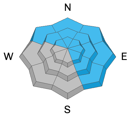
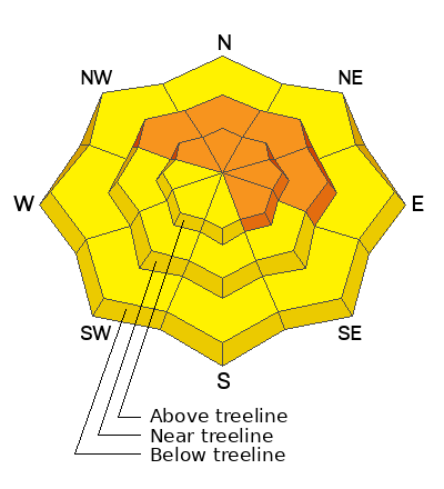
CONSIDERABLE avalanche danger is found on wind drifted slopes at and above treeline. Human triggered avalanches are LIKELY especially on steep, leeward slopes, and particularly those with an easterly component to their aspect. In addition... while becoming more the exception than the rule, steep, rocky, slopes with a shallow snowpack is bulls-eye terrain where you can still trigger an avalanche that breaks to old snow near the ground.
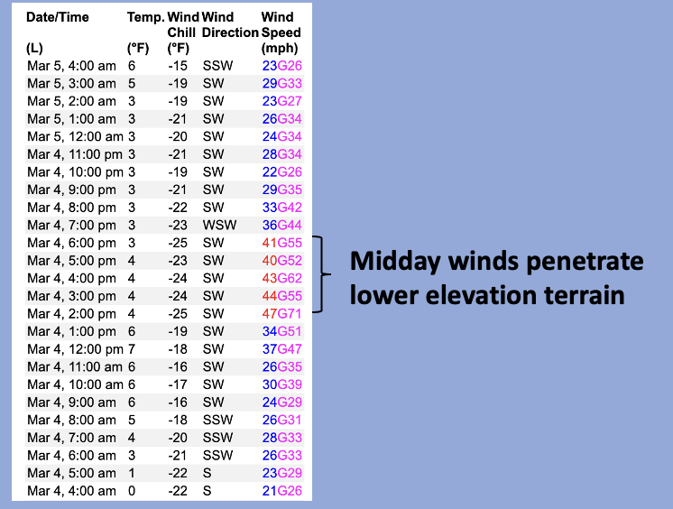
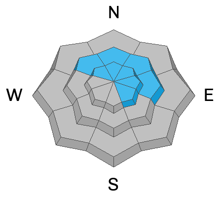
MODERATE avalanche danger exists below treeline on shady slopes, where recent winds swirl and penetrate lower elevation terrain. Human triggered avalanches are POSSIBLE on steep slopes with recent deposits of wind drifted snow.

Looking for a simple exit strategy? Well then, you came to the right place!
The Uintas have an abundance of low angle, roly-poly terrain, less than 30 degrees in steepness where you can carve deep trenches, get faceshots, and have an absolute blast.... done, done, and done :)
Low
Moderate
Considerable
High
Extreme
Learn how to read the forecast here
Special Announcements
We are seeking a passionate individual to join us as Executive Director of the nonprofit Utah Avalanche Center. Click here for more information.
Weather and Snow
Nowcast- After a brief break late Monday, clouds began streaming into the region overnight, and yeah... it's breezy. Winds from the southwest winds blew in the 20's and 30's overnight and continue in the same spirit of their windiness early this morning. It'll feel like winter when you step out to fire up your steel horse with temperatures registering in the single digits and low teens. A few more inches of low density snow stacked up Monday, bringing three day storm totals close to 18". Riding and turning conditions are all time and yup... it's over-the-hood and over-the-head :)
Forecast- A slightly warmer, yet weak little impulse slides into the Uinta zone today and that'll keep scattered snow showers going throughout the day. No earth-shattering accumulations, just a couple inches expected. Temperatures climb out of the deep freeze and bump into the upper 20's by late afternoon. West and southwest winds stay busy at work, blowing in the 20's and 30's near the high peaks.
Futurecast- Unsettled weather is on tap through midweek, with a slightly stronger system in the queue for Thursday. Scattered snow wraps up the workweek.

Recent Avalanches
Manageable in size and scope, I found shallow wind drifts and storm snow sluffs were yesterday's avy flavor of the day during my travels in Weber Canyon. Mark found similar conditions in Mill Hollow.

For all Uinta observations and recent avalanche activity click HERE.
Ad
Avalanche Problem #1
Wind Drifted Snow
Type
Location
Likelihood
Size
Description
24 hour data dump from Windy Peak (10,662')
Days of wind blowing from the south, southwest, and west conspire with recent storm snow to whip up fresh cornice and shallow drifts sensitive to ur additional weight. Yesterday, I found fresh drifts predictably breaking in front of my skis... nothing too alarming. Once you lose the wind, you lose the problem. Sheltered terrain offers deep, chin-tickling snow.
Avalanche Problem #2
Persistent Weak Layer
Type
Location
Likelihood
Size
Description
As the snowpack grows deep and more homogeneous, the odds of triggering a dangerous avalanche that breaks to weak snow near the ground diminish. But there's a disclaimer in small print, because we don't trigger scary, dangerous avalanches from deep portions of snow, rather it's from shallow, thin pieces of snow like around rocks or bushes, barely hidden under the snow surface. Whether it's from multiple avalanches or wind scouring, bulls-eye terrain is steep, rocky slopes facing the north half of the compass, especially in the wind zone where the pack has remained thin this year. With so much wind blowing from the south, these slopes may easily have triple the load of storm snow stacking up on them as a result of recent wind loading.
Becoming more the exception than the rule, I remotely triggered a large slide like this back on Feb 24th from hundreds of feet away (photo below).
Avalanche Problem #3
New Snow
Type
Location
Likelihood
Size
Description
Yesterday, in wind sheltered terrain, I found the new snow easily sluffing on sustained, steep slopes.... totally manageable by toning your slope angle down a few degrees. In addition, as the storm snow settles, it'll gain some body and transform into more cohesive snow... a soft slab. Tweaking small test slopes and road banks will give you great feedback to see how the terrain is reacting before center-punching a big, committing line.
Additional Information
The Uinta weather station network was upgraded this summer and all that real-time info is found HERE. Simply click on "western Uinta" tab and then "weather stations" tab.

We are always looking for snow and avalanche observations or just general riding conditions. So... if you see something, say something. You can reach me directly at [email protected] or 801-231-2170.
Also, if you're looking for more avy education opportunities for yourself, your crew, or your club please don't hesitate to reach out to me and we'll find a presentation, class, or clinic for ya!
General Announcements

Issued at 0400 on Tuesday, March 5th this forecast will be updated by 0700 Wednesday, March 6th, 2024.
This forecast is from the U.S.D.A. Forest Service, which is solely responsible for its content. This forecast describes general avalanche conditions and local variations always occur.