Forecast for the Uintas Area Mountains

Mark Staples
Issued by Mark Staples for
Monday, March 4, 2024
Relentless winds and a solid foot of new snow over the last two days makes the avalanche danger CONSIDERABLE near and above treeline today. Avoid wind-loaded slopes where avalanches are likely.
Below treeline, winds were still able to load many slopes and the avalanche danger is MODERATE where human-triggered slides are definitely possible.

The simple solution is always to take advantage of all the rolling terrain less than 30 degrees in steepness and find slopes untouched by the wind.
Low
Moderate
Considerable
High
Extreme
Learn how to read the forecast here
Special Announcements
We are seeking a passionate individual to join us as Executive Director of the nonprofit Utah Avalanche Center. Click here for more information.
Weather and Snow
Yesterday, an additional 4-7" of snow fell (0.3-0.5" water) bringing the storm total to 12-18" of new snow (1.0-1.3" water) although I bet there are some places with nearly 2 feet of new snow. Winds yesterday from the W and SW moved a lot of that snow.
This morning temperatures are back in the single digits F with winds from the S averaging 15-35 mph and gusting 30-50 mph. Skies are cloudy and some snow is falling.
Today will stay cold and breezy with more light snowfall. Temperatures will climb into the teens F and maybe into the low 20s F at lower elevations. Winds from the WSW will blow 10-20 mph but increase later this morning with gusts in the 40s. By the end of the day another 2-4" of snow should accumulate.

On and off snowfall will continue through Thursday with generally cold temperatures. Winds really calm down by Wednesday afternoon, and clear sunny skies are possible Friday and Saturday. The general outlook two weeks ahead is below normal temperatures and above normal precipitation.
Recent Avalanches
No avalanches have been reported in the last three days, but I suspect it has been hard to spot any recent avalanches through all the snow and blowing snow.
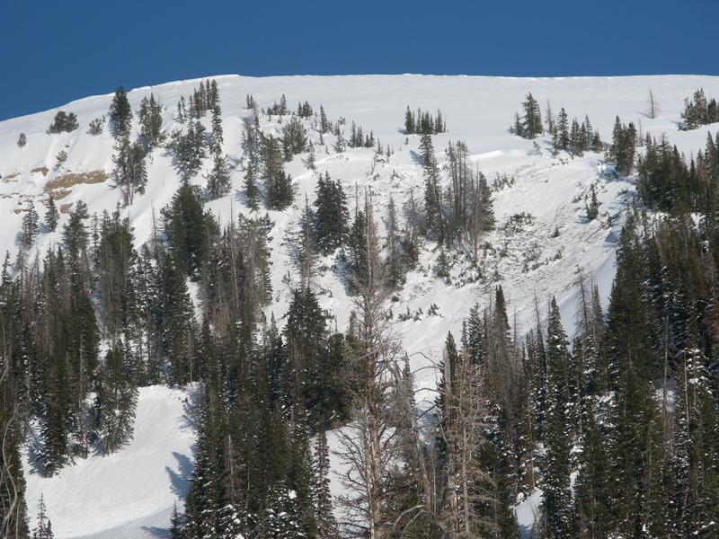
A notable avalanche occurred above Mill Hollow off of Duchesne Ridge on Thursday. It was remotely triggered (from a distance), most likely fracturing on faceted snow near a heat crust buried by last Tuesday's storm snow. We'll be looking to see if any other avalanches break on that layer.
For all Uinta observations and recent avalanche activity click HERE.
Ad
Avalanche Problem #1
Wind Drifted Snow
Type
Location
Likelihood
Size
Description
This weekend, winds reached far below treeline and left few slopes untouched, blowing mostly from the south and occasionally from the west and southwest. These winds have transported tons of snow and formed both soft and hard slabs of wind drifted snow that can easily produce avalanches.
The tricky thing about these wind slabs is that some can stabilize quickly while others remain easy to trigger. Making it more tricky is that some wind slabs on east and southeast facing slopes may be resting on a crust with some small facets next to it that were buried on Tuesday. This crust/facet combo may allow these wind slabs to remain unstable for longer.
Avalanche Problem #2
Persistent Weak Layer
Type
Location
Likelihood
Size
Description
A less common but very deadly avalanche concern is where winds loaded northerly facing slopes that have avalanched several times this winter and may break on old facets at the ground again. Most of this activity has been the Chalk Creek area on big, steep slopes near and above treeline. With so much wind blowing from the south, these slopes may easily have triple the load of snow on them now as a result of wind loading.
Craig remotely triggered a large slide like this back on Feb 24th from hundreds of feet away (photo below). I wouldn't be surprised today if someone were able to trigger another one of these avalanches breaking at the ground by simple riding near it.
Avalanche Problem #3
New Snow
Type
Location
Likelihood
Size
Description
On slopes untouched by the wind (which will be few), the new snow should easily sluff and possibly fail as a soft slab on a layer of graupel that fell during frontal passage Saturday afternoon.
Search for slopes unaffected by wind and watch how the new snow reacts on small test slopes and road banks.
Additional Information
The Uinta weather station network was upgraded this summer and all that real-time info is found HERE. Simply click on "western Uinta" tab and then "weather stations" tab.

We are always looking for snow and avalanche observations or just general riding conditions. So... if you see something, say something. You can reach me directly at [email protected] or 801-231-2170.
Also, if you're looking for more avy education opportunities for yourself, your crew, or your club please don't hesitate to reach out to me and we'll find a presentation, class, or clinic for ya!
General Announcements

Issued at 0700 on Monday, March 4th this forecast will be updated by 0700 Tuesday, March 5th, 2024.
This forecast is from the U.S.D.A. Forest Service, which is solely responsible for its content. This forecast describes general avalanche conditions and local variations always occur.