


Forecast for the Uintas Area Mountains

Issued by Mark Staples on
Sunday morning, March 3, 2024
Sunday morning, March 3, 2024
Very strong winds from the south combined with 8-15 inches of new snow have made the avalanche danger HIGH above treeline. More snow and more wind today will make both natural and human triggered avalanches likely. Some slopes may produce large avalanches breaking at the ground. Stay away from big bowls and other big slopes above treeline today.
Slopes near treeline will have dangerous conditions and a CONSIDERABLE avalanche danger.
Strong winds have reached below treeline and the danger is MODERATE on slopes below treeline. The most likely slopes to avalanche are ones with fresh difts of wind-blown snow.
The simple solution is always to take advantage of all the rolling terrain less than 30 degrees in steepness and seek out the few slopes untouched by the wind.

Low
Moderate
Considerable
High
Extreme
Learn how to read the forecast here
 Special Announcements
We are seeking a passionate individual to join us as Executive Director of the nonprofit Utah Avalanche Center. Click here for more information.
 Weather and Snow
Snow and water totals since yesterday are about 6 inches of snow at many places but 8-15 inches at higher elevations (0.6-1.0 inches of water) with the north slope being favored. Snowfall paused overnight but started again this morning as another front crossed over northern Utah. Snowfall should taper off this afternoon with an additional 3-5 inches accumulating today.
Winds peaked at 92 mph yesterday from the south and were steady at 40-50 mph. They briefly shifted direction blowing from the NW last night during a lull, but winds this morning picked up again from the south blowing 20-25 mph. Winds will be increasing again this morning from the SW and then from the W later today blowing 30-40 mph at upper elevations with some stronger gusts.
Temperatures plummeted overnight and are in the single digits F this morning. Cold air over the area today will keep temperatures from warming much and will struggle to rise into the low teens F.
This week has snow in the forecast every day with cold temperatures, nothing major but several inches each day with possible clearing at the end of the week and next weekend. No major wind events are expected.
 Recent Avalanches
No avalanches have been reported in the last two days, but few people were out yesterday or even able to see much when the snow kicked in.
A notable avalanche occurred above Mill Hollow off of Duchesne Ridge. It was remotely triggered (from a distance), most likely fracturing on faceted snow near a heat crust buried by Tuesday's storm snow.
For all Uinta observations and recent avalanche activity click HERE.

Avalanche Problem #1
Persistent Weak Layer
Type
Location
Likelihood
Size
Description
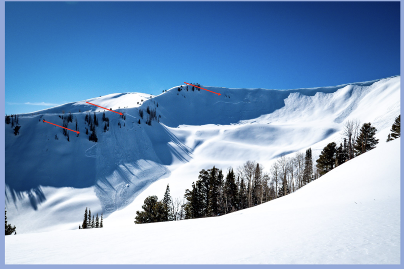
Steep, upper elevation slopes mostly in the Chalk Creek area have continued to produce large sporadic avalanches breaking to the ground on old faceted layers. Mostly on north-ish facing slopes. Yesterday's snowfall added more stress to these slopes; HOWEVER, yesterday's very strong south winds really added a lot of load to these northerly facing slopes and increasing the odds of triggering a large avalanche.
Simply riding under or near one of these big slopes may be enough to trigger a large avalanche.
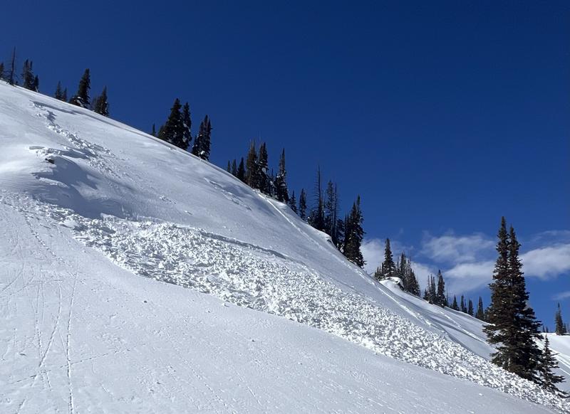
Below is a good example in Weber Canyon. This east facing slope produced a large slide following Tuesday's snow and wind.
Avalanche Problem #2
Wind Drifted Snow
Type
Location
Likelihood
Size
Description
Winds blowing from the south and west will be the main problem. They will add stress to deeply buried weak layers described above. They will also continue form hard slabs of wind drifted snow that will be easy to trigger today. As winds increase again today and more snow falls, I expect some wind slabs to release on their own.
Because winds have been blowing so strong, fresh wind slabs will be found well below treeline.
An additional issue is that some weak, faceted snow formed on the snow surface prior to Tuesday's snow (now buried 1-1.5' deep) and will make any fresh wind slabs especially sensitive and allow them to break a little deeper. They may even be remotely triggered like the avalanche in the video below except they will break deeper and wider.
Avalanche Problem #3
New Snow
Type
Location

Likelihood
Size
Description
On slopes untouched by the wind (which will be few), the new snow should easily sluff and possibly fail as a soft slab on a layer of graupel that fell during frontal passage yesterday afternoon.
Search for slopes unaffected by wind and watch how the new snow reacts on small test slopes and road banks.
Additional Information
The Uinta weather station network was upgraded this summer and all that real-time info is found HERE. Simply click on "western Uinta" tab and then "weather stations" tab.
We are always looking for snow and avalanche observations or just general riding conditions. So... if you see something, say something. You can reach me directly at [email protected] or 801-231-2170.
Also, if you're looking for more avy education opportunities for yourself, your crew, or your club please don't hesitate to reach out to me and we'll find a presentation, class, or clinic for ya!
General Announcements
Issued at 0700 on Sunday, March 3rd this forecast will be updated by 0700 Monday, March 4th, 2024.
This forecast is from the U.S.D.A. Forest Service, which is solely responsible for its content. This forecast describes general avalanche conditions and local variations always occur.