Forecast for the Uintas Area Mountains

Craig Gordon
Issued by Craig Gordon for
Thursday, February 9, 2023
A little bit of snow... a whole lotta wind-
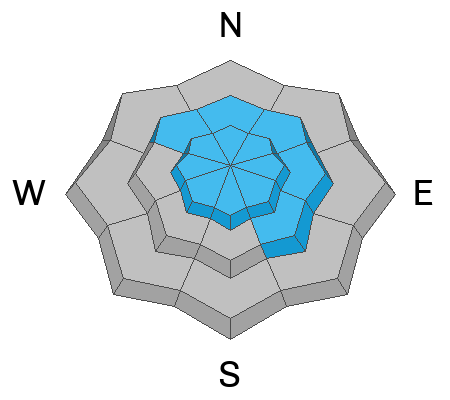
Yesterday's strong winds with an inch or two of snow, conspire to produce dense drifts that'll react to our additional weight. Look for MODERATE avalanche danger around the compass on upper elevation slopes in the wind zone and northerly, leeward terrain near treeline. In either case, human triggered avalanches are possible, especially on steep slopes with recent deposits of wind drifted snow, and particularly in terrain with an easterly component to its aspect. Lose some elevation, you lose the wind, and you lose the problem. Generally LOW avalanche danger is found on lower elevation terrain where human triggered avalanches are UNLIKELY.

Low
Moderate
Considerable
High
Extreme
Learn how to read the forecast here
Special Announcements
Huge thanks not only to Pep Fujas and the crew from WNDR Alpine for hosting last nights State of the Snowpack prezo, but also to everyone who took time out of their busy lives, pack the house, and make a commitment to understanding the snowpack better. The entire night, the vibe, and the SRO energy were unreal... and for that... I am truly grateful :)
Weather and Snow
Nowcast- Yesterday's cold front slammed into the region with southwest, west, and then northwest winds blasting into the 60's, yet delivering just and inch or two of low density snow... what a waste of weather! Currently, skies are clear and temperatures in the single digits, as northerly winds blow 15-25 mph near the high peaks. Soft snow is gonna be elusive today, but swaths of settled powder are still found on mid elevation, wind sheltered slopes.
Forecast- High pressure builds over the region and we'll see mostly sunny skies with temperatures climbing out of the deep freeze and into the mid 20's. Northerly winds remain reasonable, blowing in the teens near the high ridges.
Futurecast- Quiet weather is on tap to round out the work week. Hope is on the horizon for a storm materializing right around Valentines Day... I'll keep ya posted as deets develop.

Our light fluffy snow took a hard hit yesterday... but on Tuesday, Ted found cold shallow pow in Whitney Basin, whilst Nikki stomped around Mirror Lake Highway. In either case, they both found easy riding on a go-anywhere base.
Huge thanks for all the great obs streaming in from the eastern front. Detailed trip reports and recent obs are found HERE.
Recent Avalanches
No significant avalanche activity to report, but if ya wanna geek out, click HERE to track this years slide activity throughout the range.
Ad
Avalanche Problem #1
Wind Drifted Snow
Type
Location
Likelihood
Size
Description
A 24 hour data dump from Windy Peak (10,662') shows our recent wind run amd the evolution of a very angry inch of snow
Rippin' winds and a little fresh snow whip up both hard and soft wind drifts and deliver them on steep leeward slopes and cross-load terrain features like chutes and gullies. I think today's stiff and stubborn wind slabs are welded in place, but once initiated, have the potential to break deeper and wider than you might expect. So... you'll want to look for and avoid fat, rounded pillows of snow, especially if they sound hollow like a drum. This avalanche dragon is easy to navigate around by avoidance... simply lose a little elevation, you lose the wind, and you lose the problem.

Additional Information
Weather stations-
And... rime events have severely crippled the Uinta weather station network. I'm working to get it back up and running, but a few stations are found HERE (click weather stations, and then on the Western Uinta tab)
Observations-
Your observations are important, so please let me know what you're seeing... click HERE and contribute to this amazing community-based program
General Announcements
Issued at 03:31 on Thursday February 9th, this forecast expires 24 hours after the date and time posted, but will be updated by 07:00 Friday February 10th 2023.
Before it gets too crazy, now is the time to book an avalanche awareness presentation for your group, club, or posse. You can reach Craig directly at 801-231-2170 or [email protected].

This forecast is from the U.S.D.A. Forest Service, which is solely responsible for its content. This forecast describes general avalanche conditions and local variations always occur.