Forecast for the Uintas Area Mountains

Craig Gordon
Issued by Craig Gordon for
Friday, February 10, 2023
Pretty straight-forward and trending in the right direction-
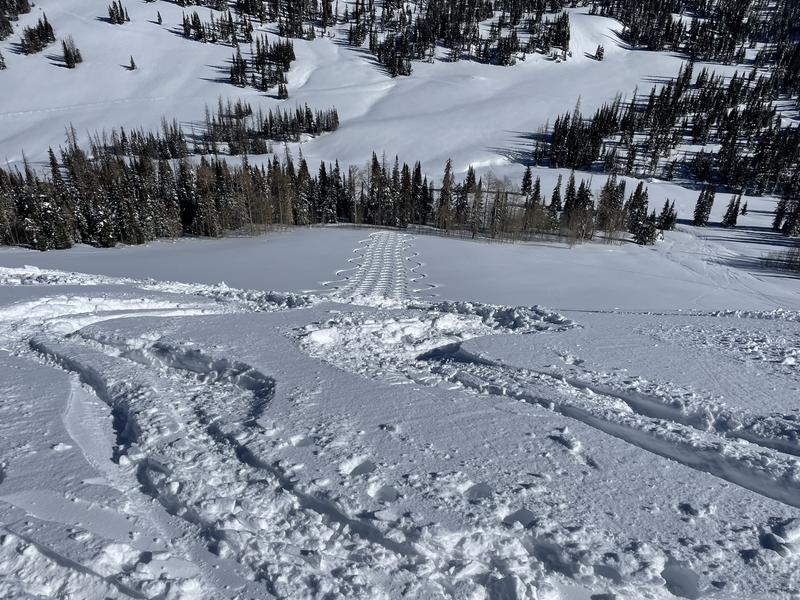
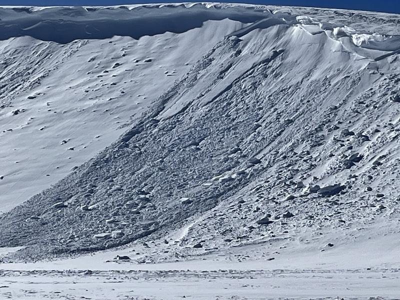
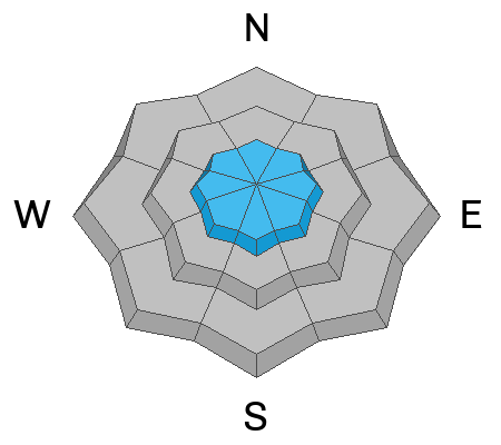
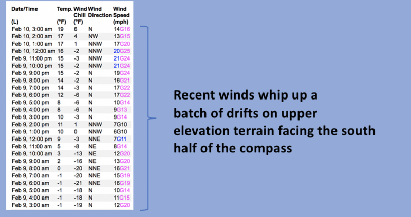
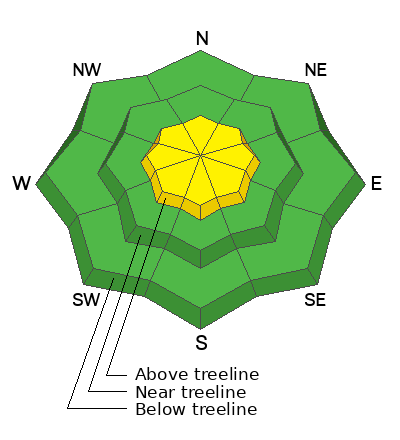
Recent wind drifts settle rapidly, yet pockets of MODERATE avalanche danger still lurk in leeward terrain around the compass above treeline in the wind zone. Human triggered avalanches are possible on steep slopes, especially those facing the south half of the compass and particularly those with an easterly component to its aspect. Lose some elevation, you lose the wind, and you lose the problem. Generally LOW avalanche danger is found on mid and lower elevation terrain where human triggered avalanches are UNLIKELY.

Low
Moderate
Considerable
High
Extreme
Learn how to read the forecast here
Weather and Snow
Nowcast- High pressure builds over the region, delivering clear skies and slightly inverted temperatures, which simply means the mercury bumps into the teens near the ridges, while registering in the single digits down low. Northwest winds are reasonable, blowing in the low to mid 20's near the high peaks. Riding and turning conditions are quite good especially in mid elevation, wind sheltered terrain where the snow maintains its 5-star Yelp rating.
Forecast- A ridge settles in over the area, delivering mostly sunny skies, temperatures climbing into the low 30's, and light northerly winds.
Futurecast- Quiet weather is on tap to round out the work week. Hope is on the horizon for a storm materializing right around Valentines Day... I'll keep ya posted as deets develop.

I underestimated how far Wednesday nights 2" reset and bright sunshine could change my spirits and deliver outstanding turning conditions, whilst offering predictable avy danger. The BOGO bonus was getting to spend the day with a rippin' crew of solid, young, snow pros (obviously farmers in a previous life :)... thanks Joey and Jeremy for an outstanding field day on the eastern front.
Huge thanks for all the great obs streaming in from the eastern front. Detailed trip reports and recent obs are found HERE.
Recent Avalanches
Wednesday's winds whipped up a handful of fresh drifts, producing a few natural, cornice triggered avalanches in the wind zone. While not widespread, terrain with similar characteristics like Tower Mountain in the image above are likely suspects.
No other significant avalanche activity to report, but if ya wanna geek out, click HERE to track this years slide activity throughout the range.
Ad
Avalanche Problem #1
Wind Drifted Snow
Type
Location
Likelihood
Size
Description
Not as stoked to go to work as I am (slacker), a 24 hour data dump from Windy Peak (10,662') shows our recent wind run which leads to isolated drifting in the wind zone.
I think most of our recent wind drift issues have settled and are gonna be elusive. However, the Uinta's are a big piece of turf and if you wanted to find a wind drift reactive to your additional weight, steep leeward slopes in the wind zone are a likely place to start. And while stiff, stubborn, and mostly welded in place, once initiated, recent drifts have the potential to break deeper and wider than you might expect. So... you'll want to look for and avoid fat, rounded pillows of snow, especially if they sound hollow like a drum. This avalanche dragon is easy to navigate around by avoidance... simply lose a little elevation, you lose the wind, and you lose the problem.

Additional Information
Weather stations-
And... rime events have severely crippled the Uinta weather station network. I'm working to get it back up and running, but a few stations are found HERE (click weather stations, and then on the Western Uinta tab)
Observations-
Your observations are important, so please let me know what you're seeing... click HERE and contribute to this amazing community-based program
General Announcements
Issued at 03:11 on Friday February 10th, this forecast expires 24 hours after the date and time posted, but will be updated by 07:00 Saturday February 11th 2023.
Before it gets too crazy, now is the time to book an avalanche awareness presentation for your group, club, or posse. You can reach Craig directly at 801-231-2170 or [email protected].

This forecast is from the U.S.D.A. Forest Service, which is solely responsible for its content. This forecast describes general avalanche conditions and local variations always occur.