Forecast for the Uintas Area Mountains

Craig Gordon
Issued by Craig Gordon for
Saturday, February 11, 2023
More the exception than the rule-
Pockets of MODERATE avalanche danger still lurk in leeward terrain above treeline in the wind zone. Human triggered avalanches are possible on steep slopes, especially those facing the north half of the compass and particularly those with an easterly component to its aspect. Lose some elevation, you lose the wind, and you lose the problem. Generally LOW avalanche danger is found on mid and lower elevation terrain where human triggered avalanches are UNLIKELY.

Low
Moderate
Considerable
High
Extreme
Learn how to read the forecast here
Weather and Snow
Nowcast- As I type at o'dark-thirty, high clouds drift into the region and that keeps a lid on inverted temperatures which register in the teens near the trailheads and mid 20's along the ridges. Southerly winds began bumping into the 20's overnight, with a spike into the 30's right after the turn of the new day, and continue in that spirit early this morning. Riding and turning conditions are slightly elusive with heat crusts making their presence known on the solars and wind jacked snow on the polars in the alpine. However, somewhere in-between is a sweet spot, especially mid elevation, wind sheltered terrain where the snow maintains its 5-star Yelp rating.
Forecast- Storminess slides well to our south, yet delivers high clouds for our zone with temperatures climbing into the mid 30's. Southwest winds blow in the upper 30's before decreasing as the day wares on.
Futurecast- Quiet weather is on tap for Sunday with a two part storm lining up for the beginning of the work week. Round one on Monday is a glancing blow with the second wave arriving Tuesday delivering a punch. I'll have a better handle on trends and timing for tomorrow's update.

I underestimated how far Wednesday nights 2" reset and bright sunshine could change my spirits and deliver outstanding turning conditions, whilst offering predictable avy danger. The BOGO bonus was getting to spend Thursday with a rippin' crew of solid, young, snow pros (obviously farmers in a previous life :)... thanks Joey and Jeremy for an outstanding field day on the eastern front.
Huge thanks for all the great obs streaming in from the eastern front. Detailed trip reports and recent obs are found HERE.
Recent Avalanches
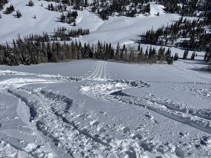
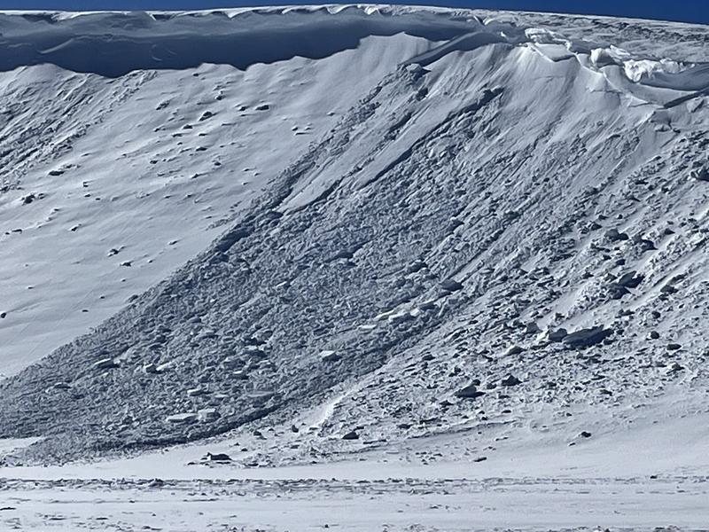
No new avalanche activity to report, but Wednesday's winds whipped up a handful of fresh drifts, producing a few natural, cornice triggered avalanches in the wind zone. While not widespread, terrain with similar characteristics like Tower Mountain in the image above are likely suspects.
No other significant avalanche activity to report, but if ya wanna geek out, click HERE to track this years slide activity throughout the range.
Ad
Avalanche Problem #1
Wind Drifted Snow
Type
Location
Likelihood
Size
Description
I think most of our recent wind drift issues have settled and are gonna be hit or miss. However, the Uinta's are a big piece of turf and if you wanted to find a wind drift reactive to your additional weight, steep leeward slopes in the wind zone are a likely place to start. And while stiff, stubborn, and mostly welded in place, once initiated, recent drifts have the potential to break deeper and wider than you might expect. So... you'll want to look for and avoid fat, rounded pillows of snow, especially if they sound hollow like a drum. This avalanche dragon is easy to navigate around by avoidance... simply lose a little elevation, you lose the wind, and you lose the problem.

Additional Information
Weather stations-
And... rime events have severely crippled the Uinta weather station network. I'm working to get it back up and running, but a few stations are found HERE (click weather stations, and then on the Western Uinta tab)
Observations-
Your observations are important, so please let me know what you're seeing... click HERE and contribute to this amazing community-based program
General Announcements
Issued at 03:13 on Saturday February 11th, this forecast expires 24 hours after the date and time posted, but will be updated by 07:00 Sunday February 12th 2023.
Before it gets too crazy, now is the time to book an avalanche awareness presentation for your group, club, or posse. You can reach Craig directly at 801-231-2170 or [email protected].

This forecast is from the U.S.D.A. Forest Service, which is solely responsible for its content. This forecast describes general avalanche conditions and local variations always occur.