UDOT PLANNED AVALANCHE CLOSURES!!

Forecast for the Uintas Area Mountains

Craig Gordon
Issued by Craig Gordon for
Tuesday, February 7, 2023
Northeast winds deliver pockets of MODERATE avalanche danger on upper elevation, leeward terrain in the wind zone, particularly on slopes with a southerly component to their aspect. Human triggered avalanches are possible, especially on steep slopes with recent deposits of wind drifted snow. Lose some elevation, you lose the wind, and you lose the problem. Generally LOW avalanche danger is found on lower elevation terrain where human triggered avalanches are UNLIKELY.

Low
Moderate
Considerable
High
Extreme
Learn how to read the forecast here
Special Announcements
Wednesday February 8th... save the date and take a date-
Please join Craig Gordon (that's me) in partnership with WNDR Alpine, Wednesday February 8th at 5:00 for a State of the Snowpack prezo at Woodbine Food Hall. It'll be fun, informative, and potentially entertaining. All the deets are found
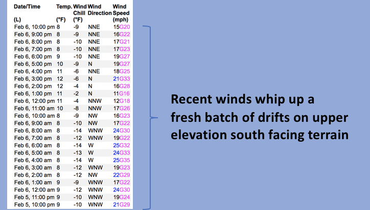
 HERE.
Weather and Snow
Nowcast- Sunday's North Slope favored storm totals are in the 8" range, while Trial Lake southward piled up half that amount. High, thin clouds along with a stray snow flurry or two, drift through the region early this morning as a waning Snow Moon makes its way to the other side of the third rock from the sun. Temperatures are winter-like, registering in the mid teens across the board. Unfortunately, northeast winds kicked in Monday right around suppertime, and while not out of hand, blow 15-25 mph near the high peaks. So... there's a little wind damage in the alpine, but wind sheltered terrain offers all-time riding and turning conditions.
Forecast- Look for clearing skies and bright sunshine with highs reaching into the mid and upper 20's, whilst northerly winds blow in the 20's and 30's near the high peaks. Overnight lows dip into the low teens.
Futurecast- A quick hitting system grazes the area Wednesday, ushering in a few scattered snow showers along with an inch or two of snow. High pressure rebounds, bringing sunny skies with slightly warming temperatures for late in the work week. A splitting system Sunday is an underacheiver, delivering clouds and a thin coat of white paint.

Huge thanks for all the great obs streaming in from the eastern front. Detailed trip reports and recent obs are found HERE.
Recent Avalanches
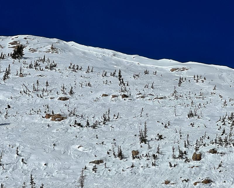
In older news... a natural slide on the east face of Mount Watson was recently reported to us. Breaking 16" deep x 300' wide and most likely failing on a thin crust/facet combo, I suspect this avalanche occurred on Feb. 1st as a result of strong northwest winds and natural cornice fall. More deets are found HERE.
But wait... there's more! If ya wanna geek out, click HERE to track this years slide activity throughout the range.
Ad
Avalanche Problem #1
Wind Drifted Snow
Type
Location
Likelihood
Size
Description
Unlike me, Windy Peak (10,662') wasn't as excited to start the workday at o'dark thirty. None-the-less, a 24 hour data run clearly illustrates recent wind trends and the evolution of fresh drifts on slopes facing the south half of the compass
Winds were all over the map prior to, during, and after our last little shot of snow. As such, I suspect shallow drifts formed on steep leeward slopes and cross-loaded terrain features like chutes and gullies, especially those with a south and west component to their aspect. No matter how you cut it, fresh drifts will react to our additional weight and may break deeper and wider than you might expect. Today you'll want to look for and avoid fat, rounded pillows of snow, especially if they sound hollow like a drum. This avalanche dragon is easy to navigate around by avoidance... simply lose a little elevation, you lose the wind, and you lose the problem.

Additional Information
Weather stations-
And... rime events have severely crippled the Uinta weather station network. I'm working to get it back up and running, but a few stations are found HERE (click weather stations, and then on the Western Uinta tab)
Observations-
Your observations are important, so please let me know what you're seeing... click HERE and contribute to this amazing community-based program
General Announcements
Issued at 03:21 on Tuesday February 7th, this forecast expires 24 hours after the date and time posted, but will be updated by 07:00 Wednesday February 8th 2023.
Before it gets too crazy, now is the time to book an avalanche awareness presentation for your group, club, or posse. You can reach Craig directly at 801-231-2170 or [email protected].

This forecast is from the U.S.D.A. Forest Service, which is solely responsible for its content. This forecast describes general avalanche conditions and local variations always occur.