Forecast for the Uintas Area Mountains

Craig Gordon
Issued by Craig Gordon for
Tuesday, February 6, 2024
The walls aren't caving in, but the avy danger bumped up a notch overnight-

Look for CONSIDERABLE avalanche danger near and above treeline. Human triggered avalanches are LIKELY on steep, leeward slopes, particularly those facing the north half of the compass, and especially those in the wind zone. Once initiated, an avalanche can get out of hand quickly if it breaks into persistent weak layers, buried deeper in our snowpack.

Winds are just starting to penetrate mid and lower elevation terrain, whipping up fresh drifts and a MODERATE avalanche danger. Steep, shady, terrain is suspect and human triggered avalanches are POSSIBLE on wind drifted slopes.

Here's your exit strategy-
Wind sheltered terrain around the low elevation dial offers generally LOW avalanche danger with human triggered avalanches UNLIKELY.
Low
Moderate
Considerable
High
Extreme
Learn how to read the forecast here
Special Announcements
Are you AR curious? Wondering if that'll bring the PWL back to life? Will repeaters be part of the equation? Asking yourself... is the snowpack ever gonna heal or how did we get here in the first place?
No worries... we've got you covered!
Please join Craig Gordon (that's me :) tonight, February 6th from 6:00-7:30 for a State of the Snowpack presentation at Black Diamond Equipment 2092 E. 3900 S. Salt Lake City Utah, 84121
Weather and Snow
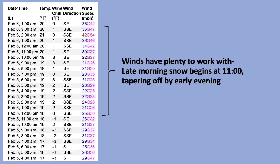
Nowcast- It's o'dark thirty and high clouds hover overhead in the wake of yesterday's storm that delivered a southside shuffle. It looks like Trail Lake through Currant Creek stacked up 7" of dense, heavy snow with about .80" H2O, while the North Slope piled up just half that amount. In either case, winds blowing from the south and southeast don't discriminate and they've been steadily ramping into the 30's and 40's, blasting into the 50's near the high peaks. Temperatures are rather warm, registering in the low to mid 30's at the trailheads, but cool into the mid 20's with elevation gain. Riding and turning conditions are gonna be a bit rugged today in open terrain, so consider lower elevation wind sheltered slopes, where you'll find soft, creamy snow.
Forecast- A short-lived lull in the action is on tap 'til the early afternoon. Expect mostly cloudy skies with temperatures climbing into the upper 30's. Southerly winds may taper for a minute or two, but return later in the day, nuking into the 50's and 60's near the high ridges. Light snow develops late in the day and the fire-hose really turns on tonight into Wednesday with a foot of snow by about mid morning.
Futurecast- Colder air slides through the region later Wednesday and that should deliver a round of lower density snowfall. It's looking like an active pattern through the upcoming weekend.
The graphic above lays out a rudimentary time frame of our upcoming storm. in addition, the National Weather Service issued a Winter Storm Warning for the Uinta zone.
Recent Avalanches
Not much significant Uinta avalanche activity to report, but several slides late last week in the Wasatch broke deep in the snowpack on layers of weak, faceted snow. One was adjacent to Brighton in Hidden Canyon and another in Days Fork. No... these aren't Uinta avalanches, but they're relevant and draw a parallel line to steep, rocky slopes in our 'hood... a heads up for sure.

Read more Uinta observations and avalanches HERE.
Ad
Avalanche Problem #1
Wind Drifted Snow
Type
Location
Likelihood
Size
Description
Above is a 24 hour data dump from Windy Peak (10,661') illustrating a ramp up in wind speed
Winds and fresh snow conspire to create a round of drifts reactive to our additional weight. Found mostly on the leeward side of mid and upper elevation north facing ridges, an unusual east component to recent wind direction will cross-load chutes and gullies facing west.

Avalanche Problem #2
Persistent Weak Layer
Type
Location
Likelihood
Size
Description
Persistent weak layers lurking deep in the snowpack have been largely dormant, but fact is... they still exist. And with a good shot of snow, water, and wind in the forecast let's not take our eyes off the prize. The snowpack is rather complex, but I've been focusing mostly on steep, rocky slopes that harbor weak, sugary snow as prime suspect terrain I'm avoiding. Once triggered, an avalanche will break deeper and wider than you might expect, delivering a knockout punch to your day.
Additional Information
The Uinta weather station network was upgraded this summer and all that real-time info is found HERE. Simply click on "western Uinta" tab and then "weather stations" tab.

We are always looking for snow and avalanche observations or just general riding conditions. So... if you see something, say something. You can reach me directly at [email protected] or 801-231-2170.
Also, if you're looking for more avy education opportunities for yourself, your crew, or your club please don't hesitate to reach out to me and we'll find a presentation, class, or clinic for ya!
General Announcements

Issued at 0400 on Tuesday, February 6th this forecast will be updated by 0700 Wednesday, February 7th, 2024.
This forecast is from the U.S.D.A. Forest Service, which is solely responsible for its content. This forecast describes general avalanche conditions and local variations always occur.