Forecast for the Uintas Area Mountains

Mark Staples
Issued by Mark Staples for
Monday, February 5, 2024
Now is a time to start stepping back with our terrain choices as we enter a prolonged period of snowfall increasing the avalanche danger and the chances of triggering an avalanche.
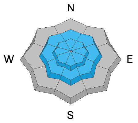
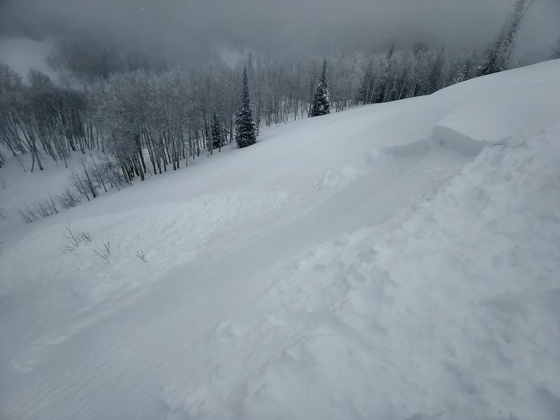
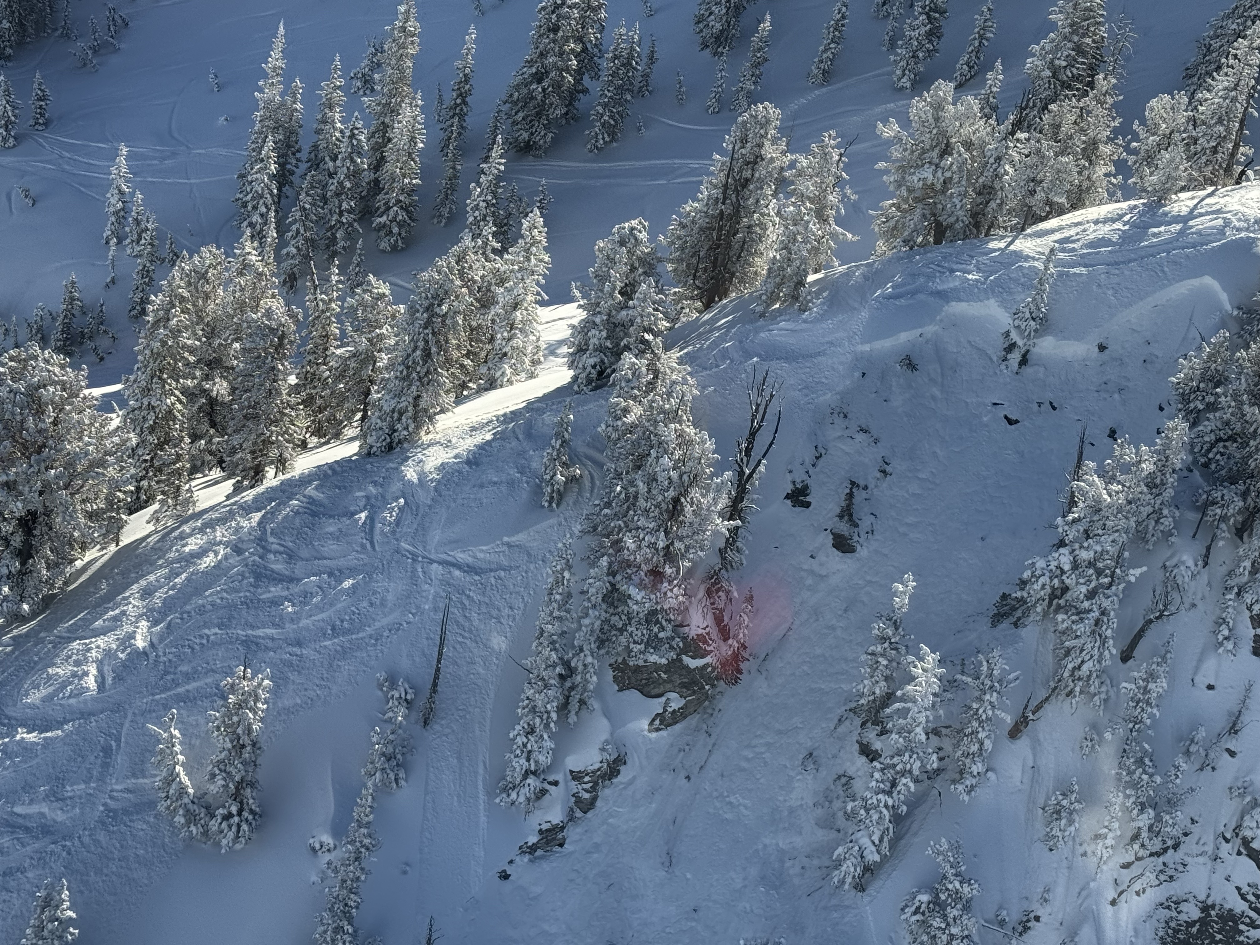
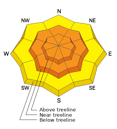
The avalanche danger is CONSIDERABLE near and above treeline where human-triggered avalanches are likely on any slope loaded by recent winds. Most slides will be slabs of wind drifted snow; however, some may also break 2-4 feet or deeper into the snowpack on buried persistent weak layers.
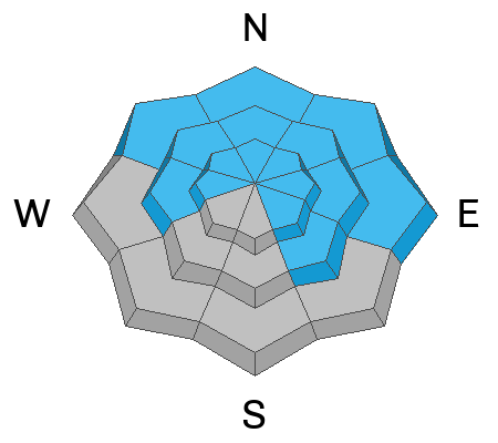
Below treeline where winds haven't affect the snow as much, the danger is MODERATE. Northerly facing slopes below treeline still harbor a persistent weak layer that may start to wake up. Also watch for any place where recent winds have transported snow and loaded steep slopes.
Low
Moderate
Considerable
High
Extreme
Learn how to read the forecast here
Weather and Snow
Today is the start of a prolonged series of storms rolling into Utah from the Pacific Ocean.
This morning temperatures are generally in the mid 20s F (mid teens F at upper elevations) which are five to ten degrees warmer than yesterday morning. Winds started ramping up yesterday afternoon and this morning they are blowing 20-45 mph and gusting 30-68 mph on ridgelines and peaks. No snow fell yesterday, but snowfall is just starting this morning. This weekend's storm delivered 7-14 inches of snow (0.7-1.0" water).
Today will be snowy and windy. The strongest winds will be this morning, but they will keep blowing 20-30 mph from the south. About 2-4 inches of snow will fall today and another couple of inches tonight. Temperatures today will remain in the mid-20s F.
The National Weather Service has issued a Winter Storm Watch for the period from Tuesday afternoon through Wednesday night with moisture coming from the south. Snow continues through the week with a shift later Thursday and early Friday when winds and moisture will come from the northwest.
Video below showing winds moving snow yesterday just as they picked up.
Recent Avalanches
As winds picked up yesterday, Craig spotted a fresh slab of wind drifted snow that happened naturally - a heads up that more will happen today (video below). Ted also observed winds moving snow yesterday near Gold Hill. On Saturday, regular observer Mike J was able to trigger soft slabs of wind drifted snow on "both sides of the compass".
There were several slides in the Wasatch yesterday that broke deep in the snowpack on layers of weak, faceted snow. One was adjacent to Brighton in Hidden Canyon and another was in Days Fork. Even though these slides were not in the Uintas, they are very relevant, and a good heads up.

Read more Uinta observations and avalanches HERE.
Ad
Avalanche Problem #1
Wind Drifted Snow
Type
Location
Likelihood
Size
Description
Soft slabs of wind drifted snow started happening yesterday when winds just started ramping up. Stronger winds and snowfall today will make wind slabs easy to trigger. Look for these on any wind loaded slope.
Watch out, winds have blown from the west this weekend and these wind slabs exist on a variety of aspects. Those changing wind directions combined with how winds swirl and get funneled through the mountains mean that wind slabs are all over the place near and above treeline.
Photo below of a fresh drift triggered on Saturday (Mike J). These will be larger and more sensitive today.
Avalanche Problem #2
Persistent Weak Layer
Type
Location
Likelihood
Size
Description
Persistent weak layers lurk deep in the snowpack closer to the ground. When these weak layers fracture they will make large, hard slab avalanches that break over wide areas. Many avalanches happened on these weak layers in mid January and left behind complex layering in snowpack with slopes having deeper or shallower snow. Steep, rocky areas with less overall snow are likely places to trigger one of these avalanches.
Two slides yesterday in the Wasatch that broke on deeper faceted layers (similar ones that exist in the Uintas) are a great heads up. With snow falling this week and winds loading many slopes, the added stress will start to increase the likelihood of triggering one of these slides.
Additional Information
The Uinta weather station network was upgraded this summer and all that real-time info is found HERE. Simply click on "western Uinta" tab and then "weather stations" tab.

We are always looking for snow and avalanche observations or just general riding conditions. So... if you see something, say something. You can reach me directly at [email protected] or 801-231-2170.
Also, if you're looking for more avy education opportunities for yourself, your crew, or your club please don't hesitate to reach out to me and we'll find a presentation, class, or clinic for ya!
General Announcements

Issued at 0700 on Monday, February 5th this forecast will be updated by 0700 Suday, February 6th, 2024.
This forecast is from the U.S.D.A. Forest Service, which is solely responsible for its content. This forecast describes general avalanche conditions and local variations always occur.