Forecast for the Uintas Area Mountains

Craig Gordon
Issued by Craig Gordon for
Wednesday, February 7, 2024
UPDATE 2:20 PM Wednesday - The UAC has issued an AVALANCHE WARNING. Avalanches are happening now. Strong winds and heavy snowfall have overloaded the snowpack. The avalanche danger has reached HIGH and traveling in avalanche terrain is NOT recommended.
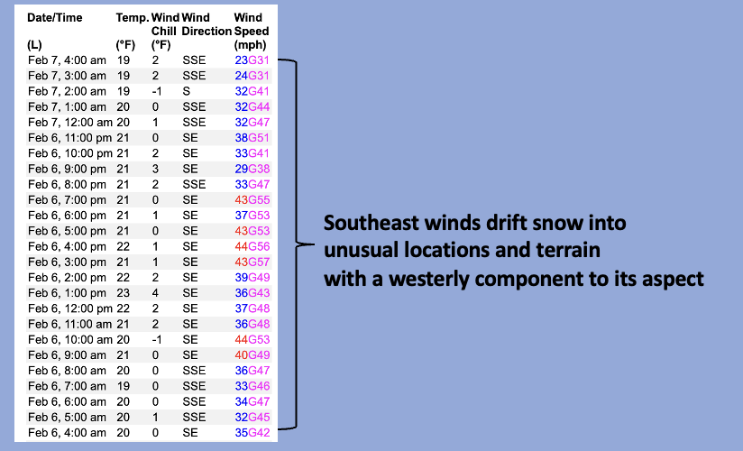
All blow and no snow... the avy danger holds steady-

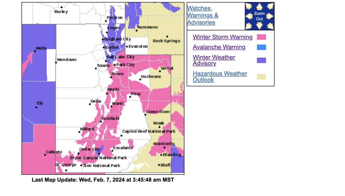
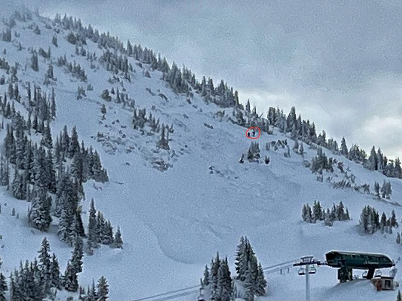
Look for CONSIDERABLE avalanche danger near and above treeline. Human triggered avalanches are LIKELY on steep, leeward slopes, particularly those facing the north half of the compass, and especially those in the wind zone with a hint of west to their aspect. Once initiated, an avalanche can get out of hand quickly if it breaks into persistent weak layers, buried deeper in our snowpack.

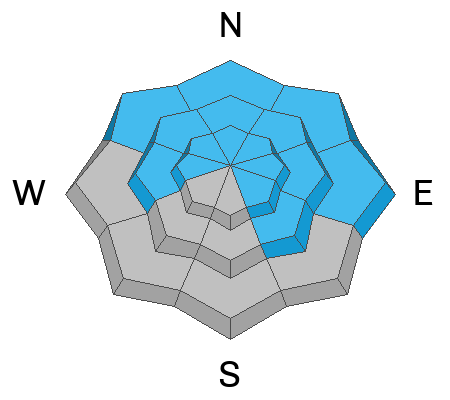
Winds penetrate mid and even a handful of lower elevation slopes, whipping up fresh drifts and a MODERATE avalanche danger. Steep, shady, terrain is suspect and human triggered avalanches are POSSIBLE on wind drifted slopes.

Here's your exit strategy-
Wind sheltered terrain at lower elevations, particularly slopes facing the south half of the compass, offer generally LOW avalanche danger and human triggered avalanches UNLIKELY.
Low
Moderate
Considerable
High
Extreme
Learn how to read the forecast here
Special Announcements
Thanks to an amazing cast of characters who devoted time out of their busy lives, made the investment on continuing their avy awareness journey, and joined me for last night's State of the Snowpack prezo at Black Diamond Equipment. Great to see old friends and meet new ones along the way!
If you missed last night I've got ya covered... please join me at Evo Salt Lake, tomorrow Thursday Feb. 8th from 6:00-7:30 PM. It's free, it's fun, and all the deets are found HERE.
Weather and Snow
Nowcast- Dang... I promised a nice shot of snow and all we're getting is a big blast of blow! Ridgetop winds are relentless, blowing 30-45 mph from the south and southeast, gusting to near 60 mph near the high peaks. Last night's moth-eaten storm fell apart, by-passed most of the range, but the Mirror Lake Corridor and the upper reaches of Wolf Creek were able to squeeze out 5" of snow with about .50" H2O. With mostly cloudy skies overhead temperatures cooled slightly overnight and currently register in the mid and upper 20's. Riding and turning conditions are gonna be a bit rugged today in big, open terrain, so consider lower elevation wind sheltered slopes, where you'll find soft, creamy snow.
Forecast- Please be patient while we recalibrate the snow machine. As the flow turns more westerly, snowfall begins filling in later today and I'm assured we're gonna see the storm kicking in by about dinnertime. High temperatures climb into the low 30's and winds veer to the west and then northwest, tapering into the 20's and 30's by sunset. I'm cautiously optimistic we'll see 4"-8" of snow develop late in the day with a couple more inches stacking up overnight.
Futurecast- Unsettled weather is on tap through the end of the work week.
A colorful graphic from the City of Salt and our good friends at the National Weather Service with a Winter Storm Warning for the Uinta zone.
Recent Avalanches
A few naturally triggered, shallow wind drifts were reported on steep, leeward slopes in the wind zone. Otherwise relatively quiet yesterday.

Read more Uinta observations and avalanches HERE.
Ad
Avalanche Problem #1
Wind Drifted Snow
Type
Location
Likelihood
Size
Description
Above is a 24 hour data dump from Windy Peak (10,661') illustrating a relentless run of south and southeast winds
Winds and fresh snow conspire to create a round of stiff drifts reactive to our additional weight. Found mostly on the leeward side of mid and upper elevation north facing ridges, an unusual east component to recent wind direction will cross-load chutes and gullies facing west. Today's drifts may be hard and a bit stubborn, but once triggered, they're gonna pack a punch and can easily roll ya. Your best bet is to simply avoid fat, rounded pieces of snow, especially if they sound hollow like a drum.

Avalanche Problem #2
Persistent Weak Layer
Type
Location
Likelihood
Size
Description
This slide was remotely triggered by the hard working women and men of the Alta Ski Patrol yesterday while they performing avalanche mitigation work. Dozens of miles away from the Uintas, but breaking to weak snow near the ground... we've got a similar setup in our steep, rocky terrain.
Persistent weak layers lurking deep in the snowpack have been largely dormant, but fact is... they still exist and might wake up and get irritated with yesterday's snow and wind. So... let's not take our eyes off the prize. The snowpack is rather complex, but I've been focusing mostly on steep, rocky slopes that harbor weak, sugary snow as prime suspect terrain I'm avoiding. Once triggered, an avalanche will break deeper and wider than you might expect, delivering a knockout punch to your day.
Additional Information
The Uinta weather station network was upgraded this summer and all that real-time info is found HERE. Simply click on "western Uinta" tab and then "weather stations" tab.

We are always looking for snow and avalanche observations or just general riding conditions. So... if you see something, say something. You can reach me directly at [email protected] or 801-231-2170.
Also, if you're looking for more avy education opportunities for yourself, your crew, or your club please don't hesitate to reach out to me and we'll find a presentation, class, or clinic for ya!
General Announcements

Issued at 0400 on Wednesday, February 7th this forecast will be updated by 0700 Thursday, February 8th, 2024.
This forecast is from the U.S.D.A. Forest Service, which is solely responsible for its content. This forecast describes general avalanche conditions and local variations always occur.