Forecast for the Uintas Area Mountains

Craig Gordon
Issued by Craig Gordon for
Thursday, February 8, 2024
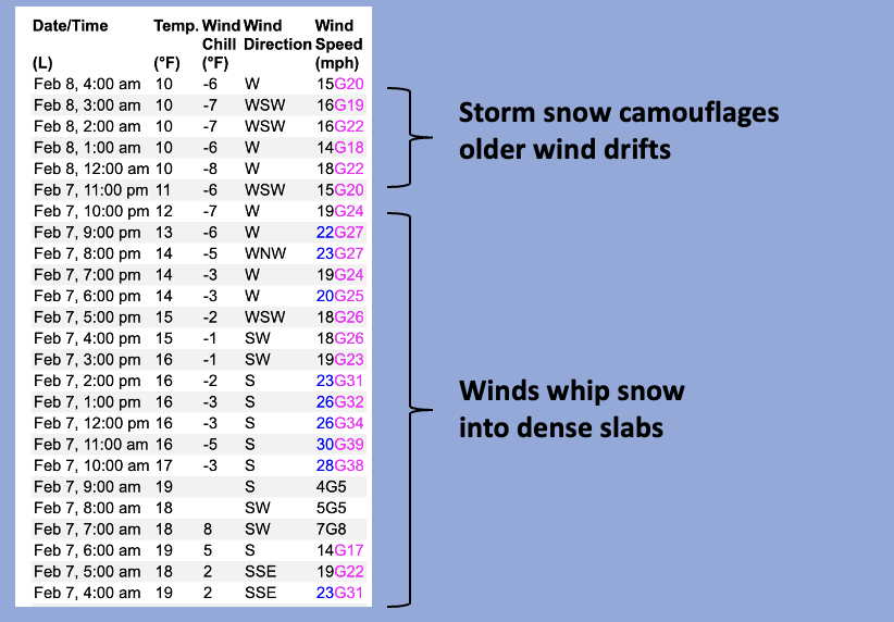
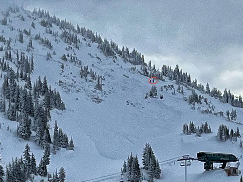
The wheels on the bus are wobbling as recent strong winds and dense heavy snow tip the scales-

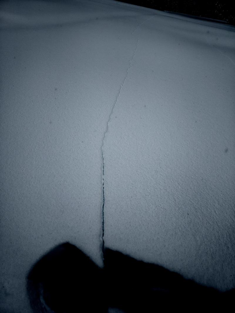
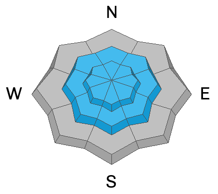
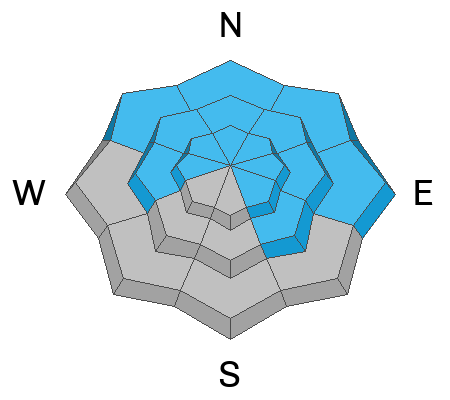
HIGH avalanche danger and sketchy conditions materialized yesterday afternoon and hold steady today near and above treeline. Both human triggered and natural avalanches are VERY LIKELY on steep, leeward slopes, particularly those facing the north half of the compass, and especially those in the wind zone. Any avalanche triggered has the distinct potential to break deeper and wider than you might expect, producing a very dangerous slide.

Recent winds and heavy storm snow overload steep slopes at lower elevation slopes, delivering CONSIDERABLE avalanche danger in our own backyards. Steep, shady, terrain is suspect and human triggered avalanches are LIKELY on wind drifted slopes right near the trailheads.

Here's your exit strategy-
Don't hide under the beds, but don't roll the dice... go carve deep trenches in big open fields or go meadow skipping in low elevation, wind sheltered terrain with no steep slopes above or adjacent to where you're traveling.
Low
Moderate
Considerable
High
Extreme
Learn how to read the forecast here
Avalanche Warning
WHAT- An AVALANCHE WARNING is in effect today through 6am MST Friday.
WHERE- For the Wasatch Range south of I-80, the Western Uinta Mountains, the Wasatch Plateau and Skyline Mountains of central Utah, and mountain ranges in southwestern Utah including the Tushars and areas near Cedar City.
WHY- Several days of strong south winds, coupled with heavy snowfall create dangerous avalanche conditions. Avoid being on or under any steep, wind drifted slope.
Special Announcements
State of the State of the Snowpack... TONIGHT!
Please join me at Evo Salt Lake, tonight Thursday Feb. 8th from 6:00-7:30 PM for a deep dive into our snowpack history, its personality, and how we avoid the avalanche dragon and manage rowdy conditions going forward. It's free, it's fun, and all the deets are found HERE.
Weather and Snow
Nowcast- There's a good chance I installed the wrong software into Marty McFly's weather machine. But man, like a turbo-charged DeLorean materializing out of thin air... it worked! Yesterday's cross-fire hurricane didn't just blossom, it was something like a pipe bomb ready to blow, and for a short time, dumped up to 3" of snow an hour. Most areas piled up nearly a foot of snow with just over an inch of H2O, while Trial Lake got absolutely fire-hosed, stacking up 16" of snow with 1.4" H2O. A bit of a break in the action ushers in moth-eaten cloud cover and temperatures in the low teens, while westerly winds blow 10-20 mph near the high peaks. Over-the head and over-the-hood... riding and turning conditions are gonna be all-time today.
Forecast- Elvis has left the stadium! A break in the action gives us mostly cloudy skies this morning with light snow developing late in the day, though most of the energy parties in the southern half of the state. Temperatures climb into the mid 20's and west-southwest winds blow 15-25 near the ridges.
Futurecast- A couple inches of snow stack up overnight and one last storm system brings additional accumulations for Friday into Saturday before high pressure ushers in the work week.
The image above spells out a clear message from the UAC.
Recent Avalanches
Viz was limited, but Micheal J braved a rugged day and found hyper-reactive fresh drifts and shooting cracks on recently wind drifted slopes. He's a got a great write up HERE.

For more Uinta observations and recent avalanche activity click HERE.
Ad
Avalanche Problem #1
Wind Drifted Snow
Type
Location
Likelihood
Size
Description
Above is a 24 hour data dump from Windy Peak (10,662'). Overnight snowfall will camouflage yesterday's stiff wind drifts
Winds have been all over the map, conspiring with fresh snow, creating a round of stiff drifts reactive to our additional weight. Found mostly on the leeward side of mid and upper elevation north facing ridges, an unusual east component to recent wind direction cross-loaded chutes and gullies facing west. Drifts are camouflaged with fresh snow and may be hard to detect, but once triggered, they're gonna pack a punch and can easily roll ya. Your best bet is to simply avoid fat, rounded pieces of snow, especially if they sound hollow like a drum.

Avalanche Problem #2
Persistent Weak Layer
Type
Location
Likelihood
Size
Description
This slide was remotely triggered by the hard working women and men of the Alta Ski Patrol Monday while they performing avalanche mitigation work. Dozens of miles away from the Uintas, but breaking to weak snow near the ground... we've got a similar setup in our steep, rocky terrain.
Persistent weak layers lurking deep in the snowpack have been largely dormant. But fact is... they still exist and I suspect they're irritated from yesterday's sudden shock, teetering in the balance, and just need a trigger like us to roll along and knock the legs out from underneath. Today isn't the day to tease the avalanche dragons, pull on its tail, or try and outsmart it... it'll bite back hard! Avoiding avalanche terrain is key. Simply stay off and out from under steep wind drifted slopes, especially those facing the north half of the compass. Once triggered, an avalanche will break deeper and wider than you might expect, delivering a knockout punch to your day.
Avalanche Problem #3
New Snow
Type
Location
Likelihood
Size
Description
Storm snow is gonna be sensitive to our additional weight and I'd avoid sustained, steep slopes at all elevations where a new snow avalanche may engulf more snow than you might anticipate.
Here's the good news is... give it a little time, new snow instabilities generally settle out rather quickly.
Additional Information
The Uinta weather station network was upgraded this summer and all that real-time info is found HERE. Simply click on "western Uinta" tab and then "weather stations" tab.

We are always looking for snow and avalanche observations or just general riding conditions. So... if you see something, say something. You can reach me directly at [email protected] or 801-231-2170.
Also, if you're looking for more avy education opportunities for yourself, your crew, or your club please don't hesitate to reach out to me and we'll find a presentation, class, or clinic for ya!
General Announcements

Issued at 0400 on Thursday, February 8th this forecast will be updated by 0700 Friday, February 9th, 2024.
This forecast is from the U.S.D.A. Forest Service, which is solely responsible for its content. This forecast describes general avalanche conditions and local variations always occur.