31st Annual Backcountry Benefit - September 12th - Tickets Available Here!

Forecast for the Uintas Area Mountains

Craig Gordon
Issued by Craig Gordon on
Friday morning, February 9, 2024
There's plenty of winter left-
Let's keep it tight, be patient, and step out cautiously the next few days, allowing the snowpack to adjust to the big midweek storm

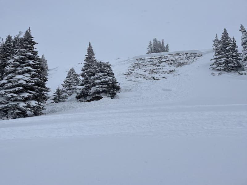
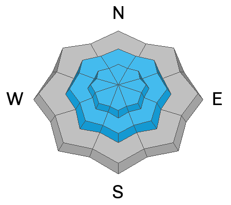
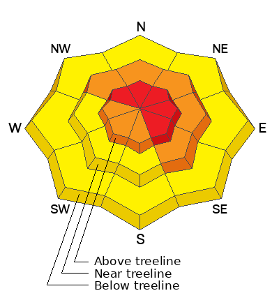
HIGH avalanche danger holds steady today near and above treeline. Human triggered avalanches are VERY LIKELY on steep, rocky, leeward slopes, particularly those facing the north half of the compass, and especially those in the wind zone. Any avalanche triggered has the distinct potential to break deeper and wider than you might expect, producing a very dangerous slide.

Recent winds and heavy storm snow overload steep, mid elevation slopes, where you'll find CONSIDERABLE avalanche danger. Steep, shady, terrain is suspect and human triggered avalanches are LIKELY on wind drifted slopes.

MODERATE avalanche danger is found on steep, lower elevation slopes, particularly those facing the north half of the compass. Not widespread and trending in the right direction, triggering a rogue, wind drifted pocket is still POSSIBLE.
Here's your exit strategy-
Don't hide under the beds, but don't roll the dice... go carve deep trenches in big open fields or go meadow skipping in low elevation, wind sheltered slopes with no steep terrain above or adjacent to where you're riding.
Low
Moderate
Considerable
High
Extreme
Learn how to read the forecast here
Special Announcements
Thanks to an amazing cast of characters who devoted time out of their busy lives, made the investment on continuing their avy awareness journey, and joined me for last night's State of the Snowpack prezo at Evo SLC. Great to see old friends and meet new ones along the way!
Weather and Snow
Nowcast- A thin band of clouds overhead deliver scattered morning snow showers and a few more inches of low density, chin tickling snow overnight. Temperatures begin the day in the low teens while winds from the west and northwest barely spin the blades on mountaintop anemometers, blowing just 5-10 mph even near the high ridges. Storm totals across the range are rather even in the high country as most automated snow sites register 14" of snow with 1.3" H2O. However, Trial Lake picks up the fumble, winks at an adoring Swiftie and takes the lead in the fourth quarter, scoring 18" of snow with 1.7" H2O. Whatever your Flavor Flav, riding and turning conditions are gonna be all-time today. Yeah... it's over-the head and over-the-hood.
Forecast- Look for scattered snow showers throughout the day with a couple inches of snow stacking up. Winds will be light, blowing 10-20 mph from the northwest. Overnight lows dip into the single digits.
Futurecast- The powder party ends this weekend as high pressure takes hold, lasting through at least the early part of the upcoming work week.
Mark got after it yesterday in the Moffit Peak environs... most importantly, he did it safely and with clear intent! Here, Mark offers sage advice on how to ride safely and still have a blast with all the new snow.
Recent Avalanches
Viz was limited, but we did get a report of a slide that was triggered remotely (from a distance) by a small crew of riders. Not huge, but the big red is... the avalanche broke on weak snow close to the ground on a steep, heavily wind loaded, rocky slope in the Currant Creek Peak area.

For more Uinta observations and recent avalanche activity click HERE.
Ad
Avalanche Problem #1
Wind Drifted Snow
Type
Location
Likelihood
Size
Description
Found mostly on the leeward side of mid and upper elevation north facing ridges, recent drifts are now camouflaged with fresh snow. And while they may be hard to detect, but once triggered, they're gonna pack a punch and can easily roll ya. Your best bet is to simply avoid fat, rounded pieces of snow, especially if they sound hollow like a drum.

Avalanche Problem #2
Persistent Weak Layer
Type
Location
Likelihood
Size
Description
Avy-savvy snow-pros, Joey Manship and Wes Shirey stomped around the Mirror Lake Corridor yesterday and found amazing riding conditions and a strengthening snowpack. Their pit profile is encouraging and Joey notes... "Although trending in the right direction there is still weak snow at the ground underneath a hard slab."
Persistent weak layers lurking deep in the snowpack have been largely dormant. But fact is... they still exist and I suspect they're irritated from the sudden shock of the midweek storm. Steep, rocky slopes with a thin snowpack are highly suspect and just need a trigger like us to roll along and knock the legs out from underneath. Today isn't the day to tease the avalanche dragons, pull on its tail, or try and outsmart it... it'll bite back hard! Avoiding avalanche terrain is key. Simply stay off and out from under steep wind drifted slopes, especially those facing the north half of the compass. Once triggered, an avalanche will break deeper and wider than you might expect, delivering a knockout punch to your day.
Avalanche Problem #3
New Snow
Type
Location
Likelihood
Size
Description
Storm snow is gonna be sensitive to our additional weight and I'd avoid sustained, steep slopes at all elevations where a new snow avalanche may engulf more snow than you might anticipate.
Here's the good news is... give it a little time, new snow instabilities generally settle out rather quickly. This problem will be a footnote by tomorrow :)
Additional Information
The Uinta weather station network was upgraded this summer and all that real-time info is found HERE. Simply click on "western Uinta" tab and then "weather stations" tab.

We are always looking for snow and avalanche observations or just general riding conditions. So... if you see something, say something. You can reach me directly at [email protected] or 801-231-2170.
Also, if you're looking for more avy education opportunities for yourself, your crew, or your club please don't hesitate to reach out to me and we'll find a presentation, class, or clinic for ya!
General Announcements

Issued at 0400 on Friday, February 9th this forecast will be updated by 0700 Saturday, February 10th, 2024.
This forecast is from the U.S.D.A. Forest Service, which is solely responsible for its content. This forecast describes general avalanche conditions and local variations always occur.