Forecast for the Uintas Area Mountains

Craig Gordon
Issued by Craig Gordon for
Friday, February 3, 2023
A sea of green suggests human triggered avalanches are UNLIKELY and the avalanche danger is generally LOW. And while there might be a shallow wind drift or two lurking on the leeward side of upper elevation ridges, they're really not big enough to boss you around. None-the-less, you should still have an exit strategy in your back pocket, especially if you're getting into steep, technical, unforgiving terrain where even a small slide can throw a curve ball at your day.

Low
Moderate
Considerable
High
Extreme
Learn how to read the forecast here
Special Announcements
Looking for some basic avy education? Well... you came to the right place! Please join us 4:00 today, Friday, Feb. 3rd at The Notch in Samak, for a free Know Before You Go prezo.
Deets are found HERE
Weather and Snow
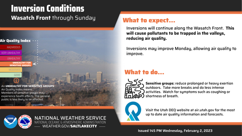
Nowcast- As a nearly full and aptly named Snow Moon sets, clear skies and fresh air await your arrival above a building valley inversion in the City of Salt. Temperatures start their work day in the low to mid 20's and southerly winds blow to 20 mph near the high ridges. And while it's been a minute or two since our last storm, soft, recycled powder is still found in wind sheltered terrain facing the north half of the compass.
Forecast- As a weak storm grazes the north half of the state, look for thickening clouds and a flurry or two late this afternoon. Temperatures climb into the mid 30's and southwest winds bump into the 30's and 40's near the high peaks as the day wares on.
Futurecast- Sunny skies return for Saturday into early Sunday. Looking into the future, a nice shot of snow slides through the area late Sunday into Monday and I think 6" is a good bet.

Feeling confidant with the snowpack structure, I've been steeping into big terrain. And... once you get past the bouncers at the door, you're instantly rewarded with a tiny turn, desk concert, and very predictable avy hazard.
Huge thanks for all the great obs streaming in from the eastern front. Detailed trip reports and recent obs are found HERE.
Recent Avalanches
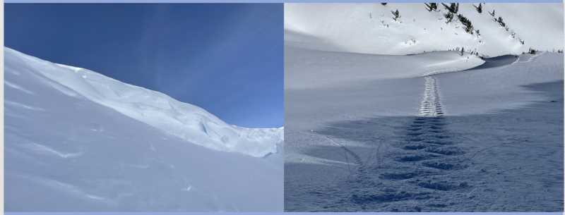
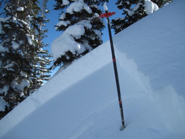
It's been generally quiet the past few days. Though yesterday, Ted stomped on his favorite test slope and found a small, yet tender, wind drift sensitive to his additional weight during his travels around Gold Hill. Easy to detect by its fat, rounded appearance, this little pocket was 1' deep and 20' wide, failing on some low density snow.
The last significant avalanche reported on Saturday, January 28th in the Mill Hollow zone. More deets found HERE.
No other significant recent avalanche activity to report. However, if ya wanna geek out, click HERE to track this years slide activity throughout the range.
Ad
Avalanche Problem #1
Normal Caution
Type
Location
Likelihood
Size
Description
About the only game in avalanche town is a shallow wind drift or two that may still be sensitive to our additional weight. Found on upper elevation leeward slopes facing the south half of the compass and cross-loaded in chutes and gullies, both old and newly formed drifts may catch you by surprise. This avalanche dragon is easy to navigate by avoidance... simply lose a little elevation, you lose the wind, and you lose the problem.

Additional Information
Get outta the valley gunk and into clean, fresh mountain air!
Weather stations-
And... rime events have severely crippled the Uinta weather station network. I'm working to get it back up and running, but a few stations are found HERE (click weather stations, and then on the Western Uinta tab)
Observations-
Your observations are important, so please let me know what you're seeing... click HERE and contribute to this amazing community-based program
General Announcements
Issued at 03:11 on Friday February 3rd, this forecast expires 24 hours after the date and time posted, but will be updated by 07:00 Saturday February 4th 2023.
Before it gets too crazy, now is the time to book an avalanche awareness presentation for your group, club, or posse. You can reach Craig directly at 801-231-2170 or [email protected].

This forecast is from the U.S.D.A. Forest Service, which is solely responsible for its content. This forecast describes general avalanche conditions and local variations always occur.