Forecast for the Uintas Area Mountains

Craig Gordon
Issued by Craig Gordon for
Saturday, February 4, 2023
Yesterday's winds bumped the hazard up a notch-
Pockets of MODERATE avalanche danger are found on upper elevation, leeward slopes in the wind zone. Human triggered avalanches are possible, especially on steep wind drifted slopes facing the north half of the compass.
Lose a little elevation, you lose the wind, and you lose the problem. Most other terrain offers LOW avalanche danger and human triggered avalanches are UNLIKELY.

Low
Moderate
Considerable
High
Extreme
Learn how to read the forecast here
Weather and Snow
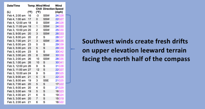
Nowcast- Skies clear in the wake of a weak cold front that slid through the region overnight, knocking temperatures into the mid teens. Southwest winds are beginning to taper, but remain obnoxious, blowing in the mid 20's near the high ridges. Our big open alpine terrain took a hit yesterday, and yup, it's been a minute or two since our last storm. But don't let your heart be troubled... soft, recycled powder is still found in wind sheltered terrain facing the north half of the compass.
Forecast- After a nice start to the day, look for increasing clouds with southwest winds ramping up as the day wares on. High temperatures climb into the mid 30's and winds bump into the 40's and 50's by about sunset.
Futurecast- The next storm system arrives midday Sunday and continues through Monday. I'm cautiously optimistic it'll deliver 8"-12" of snow for Tuesday morning.

Feeling confidant with the snowpack structure, I've been steeping into big terrain. And... once you get past the bouncers at the door, you're instantly rewarded with a tiny turn, desk concert, and very predictable avy hazard.
Huge thanks for all the great obs streaming in from the eastern front. Detailed trip reports and recent obs are found HERE.
Recent Avalanches
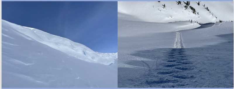
Yesterday, whilst in Upper Weber Canyon, Trevor Katz found a couple inch thick wind drift sensitive to his additional weight. Not particularly deep or packing a lot of heat, but popping out surprisingly wide (3"x100'). Trevor's got a great ob and insight on current conditions which are found
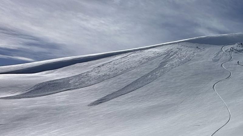
 HERE.
The last significant avalanche reported on Saturday, January 28th in the Mill Hollow zone. More deets found HERE.
But wait... there's more! If ya wanna geek out, click HERE to track this years slide activity throughout the range.
Ad
Avalanche Problem #1
Wind Drifted Snow
Type
Location
Likelihood
Size
Description
The time stamp is a little late on the draw and not as enthusiastic to go to work as I am. But, updated wind data above from Windy Peak still delivers an accurate representation of nearly real-time, upper elevation wind trends.
Strong winds yesterday and through the night, whipped up a fresh round of wind drifts that'll remain sensitive to our additional weight. Found on upper elevation leeward slopes facing the north half of the compass and cross-loaded in chutes and gullies, both old and newly formed drifts may catch you by surprise. This avalanche dragon is easy to navigate by avoidance... simply lose a little elevation, you lose the wind, and you lose the problem.

Additional Information
Get outta the valley gunk and into clean, fresh mountain air!
Weather stations-
And... rime events have severely crippled the Uinta weather station network. I'm working to get it back up and running, but a few stations are found HERE (click weather stations, and then on the Western Uinta tab)
Observations-
Your observations are important, so please let me know what you're seeing... click HERE and contribute to this amazing community-based program
General Announcements
Issued at 03:31 on Saturday February 4th, this forecast expires 24 hours after the date and time posted, but will be updated by 07:00 Sunday February 5th 2023.
Before it gets too crazy, now is the time to book an avalanche awareness presentation for your group, club, or posse. You can reach Craig directly at 801-231-2170 or [email protected].

This forecast is from the U.S.D.A. Forest Service, which is solely responsible for its content. This forecast describes general avalanche conditions and local variations always occur.