Forecast for the Uintas Area Mountains

Craig Gordon
Issued by Craig Gordon for
Sunday, February 5, 2023
A solid looking shot of snow and wind changes the avy danger today-
The day starts with MODERATE avalanche danger on mid and upper elevation, leeward slopes in the wind zone. Human triggered avalanches are possible, especially on steep wind drifted slopes facing the north half of the compass.
As the storm evolves, avalanche danger bumps up a notch and should reach CONSIDERABLE by days end. Human triggered avalanches become LIKELY on steep slopes with recent deposits of wind drifted snow.
Southerly winds blast the south half of the compass where you'll find LOW avalanche danger with human triggered avalanches UNLIKELY.

Low
Moderate
Considerable
High
Extreme
Learn how to read the forecast here
Weather and Snow
Nowcast- Through a veil of thickening clouds, a big, bright, beautiful Snow Moon cast muted light on our mountains this morning. Temperatures, like myself, start the workday rather warm, clocking in around 10 degrees higher than yesterday at this time and registering in the mid 20's. Southerly winds got a head start on the rest of the crew, beginning to ramp into the 20's and 30's right around midnight and continue in that spirit early this morning. Quality riding and turning conditions are a bit more elusive today, but don't let your heart be troubled... soft, recycled powder is still found in wind sheltered terrain facing the north half of the compass.
Forecast- A nice looking, two part storm is at our door step. Act one... look for mostly cloudy skies with temperatures not straying much from where we're at this morning. Southwest winds are gonna be a nuisance, blowing in the 40's along the high ridges, gusting to 70 mph near the high peaks. A solid shot of snow develops by early afternoon and I think a foot of snow is a good bet by Monday morning.
Futurecast- Act two arrives with colder air mid morning Monday and an additional 3"-5" is likely.

Our good friends and partners in all things weather, the SLC National Weather Service, have issued a Winter Storm Advisory for the western Uinta Mountains.
Huge thanks for all the great obs streaming in from the eastern front. Detailed trip reports and recent obs are found HERE.
Recent Avalanches
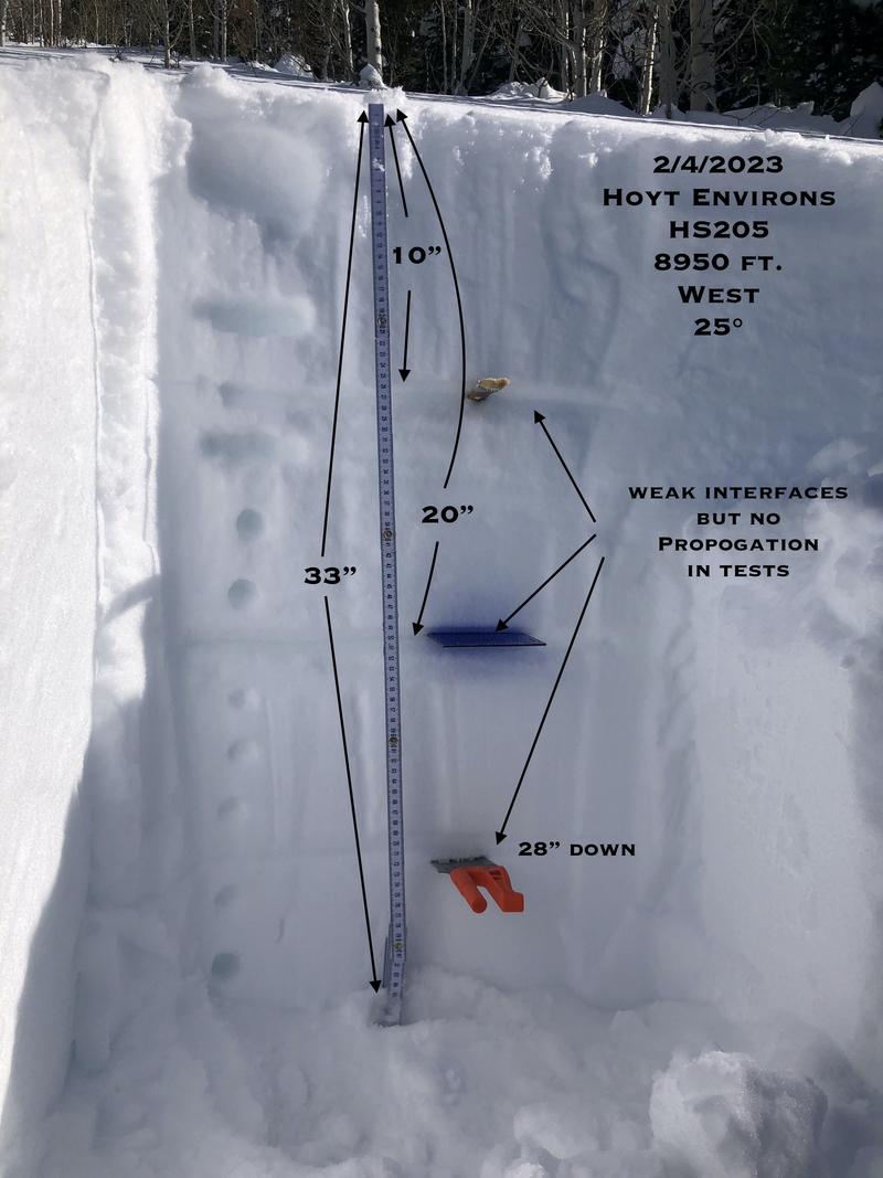
The beautiful pit profile above was submitted by the ever intrepid JG, clearly showing a solid snowpack. JG's got a rock solid feel for the Uinta's with a great ob from his travels yesterday around the Hoyt zone found HERE.
Our last significant avalanche was reported on Saturday, January 28th in the Mill Hollow zone. More deets found HERE.
But wait... there's more! If ya wanna geek out, click HERE to track this years slide activity throughout the range.
Ad
Avalanche Problem #1
Wind Drifted Snow
Type
Location
Likelihood
Size
Description
Windy Peak (10,662') delivers accurate representation of nearly real-time, upper elevation wind trends.
Winds are already busy at work whipping up a fresh round of drifts on upper elevation leeward slopes facing the north half of the compass. As today's storm evolves, drifting becomes more widespread and snow gets cross-loaded in chutes and gullies. No matter how you cut it, fresh drifts will react to our additional weight and may break deeper and wider as the day progresses. Today you'll want to look for and avoid fat, rounded pillows of snow, especially if they sound hollow like a drum. This avalanche dragon is easy to navigate past by avoidance... simply lose a little elevation, you lose the wind, and you lose the problem.

Additional Information
Weather stations-
And... rime events have severely crippled the Uinta weather station network. I'm working to get it back up and running, but a few stations are found HERE (click weather stations, and then on the Western Uinta tab)
Observations-
Your observations are important, so please let me know what you're seeing... click HERE and contribute to this amazing community-based program
General Announcements
Issued at 03:31 on Sunday February 5th, this forecast expires 24 hours after the date and time posted, but will be updated by 07:00 Monday February 6th 2023.
Before it gets too crazy, now is the time to book an avalanche awareness presentation for your group, club, or posse. You can reach Craig directly at 801-231-2170 or [email protected].

This forecast is from the U.S.D.A. Forest Service, which is solely responsible for its content. This forecast describes general avalanche conditions and local variations always occur.