Forecast for the Uintas Area Mountains

Craig Gordon
Issued by Craig Gordon for
Thursday, February 2, 2023
A sea of green suggests human triggered avalanches are UNLIKELY and the avalanche danger is generally LOW. And while there might be a shallow wind drift or two lurking on the leeward side of upper elevation ridges, they're really not big enough to boss you around. None-the-less, you should still have an exit strategy in your back pocket, especially if you're getting into steep, technical, unforgiving terrain where even a small slide can throw a curve ball at your day.

Low
Moderate
Considerable
High
Extreme
Learn how to read the forecast here
Weather and Snow
Nowcast- Above a building valley inversion in the City of Salt, the air is clear and temperatures crisp, currently registering in the single digits. Near the high peaks, west and northwest winds blow 10-20 mph. And while it's been a minute or two since our last storm, soft, recycled powder is still found in wind sheltered terrain facing the north half of the compass.
Forecast- Another glorious day is on tap with mostly sunny skies, temperatures climbing into the upper 20's, and northwest winds blowing 10-20 mph along the high ridges.
Futurecast- A little brush-by late Friday ushers in slightly cooler air, but sunny skies return for Saturday into early Sunday. Looking into the future, a potentially significant storm system slides through the area late Sunday into Monday, though uncertainty remains about timing and potential snow amounts.

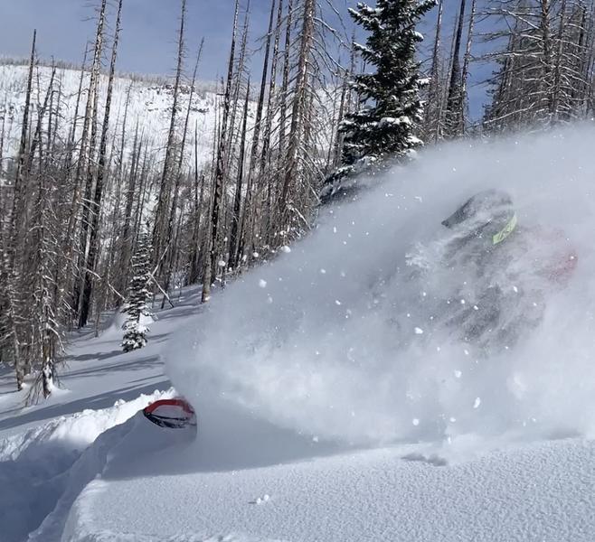
Ka-Pow! Weston D and Mark Staples took a rip around Smith-Moorehouse Monday and report amazing coverage with even more amazinger riding conditions. Their trip report is found HERE.
Huge thanks for all the great obs streaming in from the eastern front. Detailed trip reports and recent obs are found HERE.
Recent Avalanches
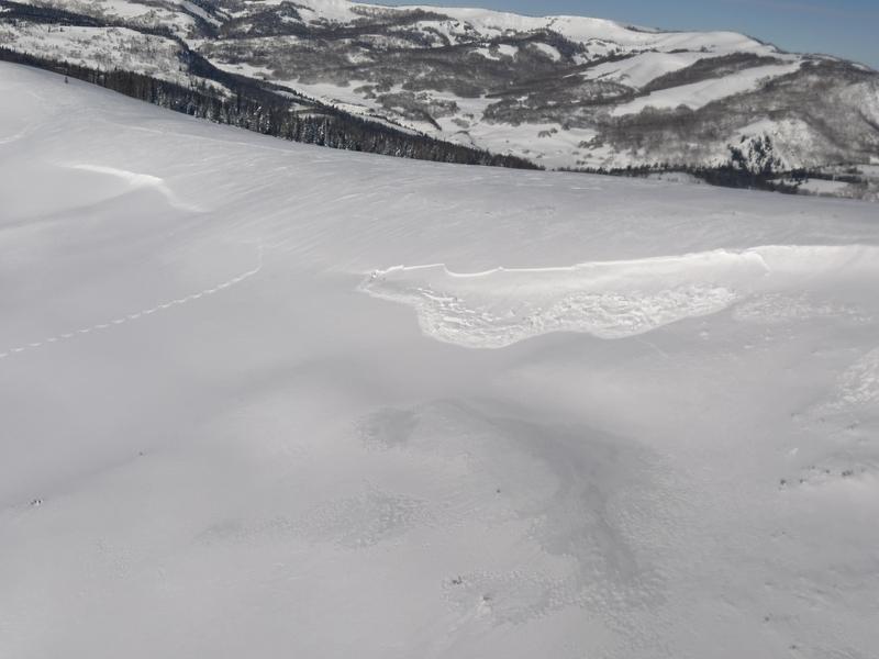
It's been generally quiet the past few days, though with a cornice drop yesterday, I intentionally triggered a shallow fresh drift on a sustained steep slope facing the south half of the compass. Not a big slide, which in fact gobbled itself up in short order as it descended the slope.
The last significant avalanche reported on Saturday, January 28th in the Mill Hollow zone. More deets found HERE.
No other significant recent avalanche activity to report. However, if ya wanna geek out, click HERE to track this years slide activity throughout the range.
Ad
Avalanche Problem #1
Normal Caution
Type
Location
Likelihood
Size
Description
About the only game in avalanche town is a shallow wind drift or two that may still be sensitive to our additional weight. Found on upper elevation leeward slopes facing the south half of the compass and cross-loaded in chutes and gullies, both old and newly formed drifts may catch you by surprise. This avalanche dragon is easy to navigate by avoidance... simply lose a little elevation, you lose the wind, and you lose the problem.

Additional Information
Get outta the valley gunk and into clean, fresh mountain air!
Weather stations-
And... rime events have severely crippled the Uinta weather station network. I'm working to get it back up and running, but a few stations are found HERE (click weather stations, and then on the Western Uinta tab)
Observations-
Your observations are important, so please let me know what you're seeing... click HERE and contribute to this amazing community-based program
General Announcements
Issued at 03:31 on Thursday February 2nd, this forecast expires 24 hours after the date and time posted, but will be updated by 07:00 Friday February 3rd 2023.
Before it gets too crazy, now is the time to book an avalanche awareness presentation for your group, club, or posse. You can reach Craig directly at 801-231-2170 or [email protected].

This forecast is from the U.S.D.A. Forest Service, which is solely responsible for its content. This forecast describes general avalanche conditions and local variations always occur.