Forecast for the Uintas Area Mountains

Craig Gordon
Issued by Craig Gordon for
Wednesday, February 1, 2023
Pockets of MODERATE avalanche danger exist on steep, upper elevation leeward slopes, especially in the wind zone at and above treeline. Both old and fresh wind drifts reactive to our additional weight are POSSIBLE, particularly on steep slopes with a south and easterly component to its aspect. Lose the wind and you lose the problem... generally LOW avalanche danger is found on mid and low elevation slopes around the compass where human triggered avalanches are UNLIKELY.

Low
Moderate
Considerable
High
Extreme
Learn how to read the forecast here
Weather and Snow
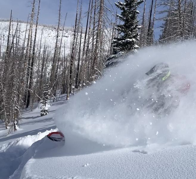
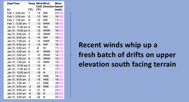
Nowcast- Mirroring my heartbeat after a big tug of pre-work juice, temperatures rebound rapidly out of the deep freeze and start the day in the teens and single digits... nearly 20 degrees warmer than at this time yesterday morning. Along the ridges it's still crisp where northwest winds blow in the mid 20's delivering windchill to -14 degrees. However, the sun is high in the sky and it'll feel good on your grill, though it did deliver a slight zipper crust on low elevation solars yesterday. But swing over to the other side of the compass and tag the polars where riding and turning conditions are all time.
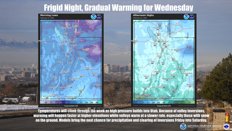
Forecast- A glorious day is on tap with mostly sunny skies, temperatures climbing into the mid 20's, and northwest winds blowing 10-20 mph along the high ridges.
Futurecast- Not much going on... we remain high and dry through the work week. Temperatures steadily increase each day and winds are generally light. A quick hitter late in the week delivers a couple traces of snow late Friday, with another stronger sytem on tap for Sunday.

Ka-Pow! Weston D and Mark Staples took a rip around Smith-Moorehouse Monday and report amazing coverage with even more amazinger riding conditions. Their trip report is found HERE.
Huge thanks for all the great obs streaming in from the eastern front. Detailed trip reports and recent obs are found HERE.
Recent Avalanches
It's been generally quiet the past few days with the last significant avalanche reported on Saturday, January 28th in the Mill Hollow zone. More deets found HERE.
No other significant recent avalanche activity to report. However, if ya wanna geek out, click HERE to track this years slide activity throughout the range.
Ad
Avalanche Problem #1
Wind Drifted Snow
Type
Location
Likelihood
Size
Description
The image above reflects a 24 hour data dump from Windy Peak (10,662') illustrating winds delivering shallow drifts to terrain facing the south half of the compass.
While there's no shortage of light snow available for transport, about the only game in avalanche town is a shallow wind drift or two that may still be sensitive to our additional weight. Found on upper elevation leeward slopes facing the south half of the compass and cross-loaded in chutes and gullies, both old and newly formed drifts may catch you by surprise, breaking deeper and wider than you might expect. This avalanche dragon is easy to navigate by avoidance... simply lose a little elevation, you lose the wind, and you lose the problem.

Additional Information
Our good friends and partners at the SLC NWS give us the heads up in the weather department... and it looks like nothin' but blue skies for a couple days :)
Weather stations-
And... rime events have severely crippled the Uinta weather station network. I'm working to get it back up and running, but a few stations are found HERE (click weather stations, and then on the Western Uinta tab)
Observations-
Your observations are important, so please let me know what you're seeing... click HERE and contribute to this amazing community-based program
General Announcements
Issued at 03:21 on Wednesday February 1st, this forecast expires 24 hours after the date and time posted, but will be updated by 07:00 Thursday February 2nd 2023.
Before it gets too crazy, now is the time to book an avalanche awareness presentation for your group, club, or posse. You can reach Craig directly at 801-231-2170 or [email protected].

This forecast is from the U.S.D.A. Forest Service, which is solely responsible for its content. This forecast describes general avalanche conditions and local variations always occur.