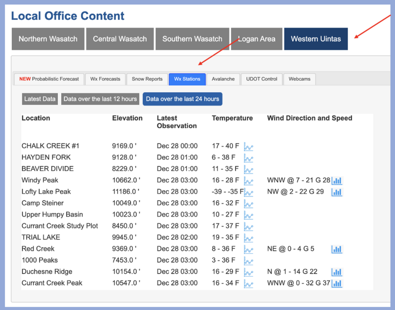
Forecast for the Uintas Area Mountains

Mark Staples
Issued by Mark Staples for
Sunday, December 31, 2023
Happy New Year's Eve! The avalanche danger is LOW on all aspects and elevations. Right now we're watching the condition of the snow surface which continues to weaken and will be problem when snowfall returns.
Low
Moderate
Considerable
High
Extreme
Learn how to read the forecast here
Special Announcements
To fulfill our mission, the UAC relies on our amazing backcountry community. Your support helps pay for the daily avalanche forecast, free awareness presentations across the state, and new tools like the new Avalanche and Observation Explorer. As the end of the year approaches, please consider donating to the UAC.
Weather and Snow
This morning temperatures are mostly in the low to mid 20s F and winds from the southeast are only blowing 14 mph gusting to 20 mph on the high peaks.
Today will be sunny with temperatures climbing into the low 30s F and winds will remain light.
This coming week will be clear and dry through Wednesday. On Thursday, a storm system far to the south should bring some snow to southern Utah with a chance for some flurries in the Uintas. A much more potent storm pattern is lining up to start next weekend. Fingers crossed.
On shaded slopes protected from winds, the snow remains soft. We call it "loud powder" because the snow has faceted and weakened and makes some noise when you kick it with your feet or skis. Regular observer Mike J found great snow above 10k with snow about 3 feet deep and still "quite supportive".
Recent Avalanches
Yesterday, skiers above Smith and Morehouse Reservoir triggered a dry loose sluff with debris over a foot deep. There have been reports from the Wasatch of similar sluffs. What's concerning about these avalanches is that they indicate how weak the snow surface has become. When snowfall returns, today's snow surface will be the weak layer under future avalanches. Craig found similarly weak snow two days ago near Chalk Creek.

Trip reports and the latest observations are found HERE.
Ad
Avalanche Problem #1
Normal Caution
Type
Location
Likelihood
Size
Description
No matter how low the danger is, there's always some risk of avalanches, and we always take the normal precautions just in case. Carrying avalanche rescue gear and exposing only one person at at time are the key steps so that if someone is buried, it's only one person and the rest of group will be available to dig that person out.
Watch for a rogue wind slab or sluff could roll downhill with you.
Additional Information
The Uinta weather station network was upgraded this summer and all that real-time info is found HERE. Simply click on "western Uinta" tab and then "weather stations" tab.

We are always looking for snow and avalanche observations or just general riding conditions. So... if you see something, say something. You can reach me directly at [email protected] or 801-231-2170.
Also, if you're looking for more avy education opportunities for yourself, your crew, or your club please don't hesitate to reach out to me and we'll find a presentation, class, or clinic for ya!
General Announcements

Issued at 0700 on Sunday, December 31st this forecast will be updated by 0700 Monday, January 1st, 2024.
This forecast is from the U.S.D.A. Forest Service, which is solely responsible for its content. This forecast describes general avalanche conditions and local variations always occur.