Forecast for the Uintas Area Mountains

Mark Staples
Issued by Mark Staples for
Sunday, January 7, 2024
It's great to see winter come back with cold weather and more snow! But avalanche conditions will be changing this week depending on snowfall and wind.
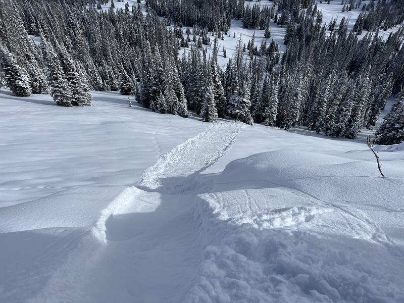
Today the avalanche danger is MODERATE above and near treeline where soft slabs of wind drifted snow and sluffs of new snow are the issue. The main strategy today is to avoid pockets of wind drifted snow.
Low elevations below treeline have not received as much new snow or wind and have a LOW avalanche danger.
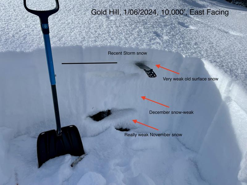
Lastly - don't let all the new snow fool you into forgetting that the snowpack is still quite thin. There are a lot of rocks and stumps lurking just below the surface.
Low
Moderate
Considerable
High
Extreme
Learn how to read the forecast here
Special Announcements
Sign up for forecast region-specific text message alerts about changing avalanche conditions, watches, and warnings.
Weather and Snow
This morning as of 6 a.m., 5-6 inches of snow (0.4" water) has fallen in the southern part of the Uintas near Strawberry Reservoir as well as a few places closer to the Kamas Valley, while only a trace to 1 inch of snow fell in the northern part of the range. Temperatures up high are in the single digits F and in the mid to low teens around trailheads. Winds overnight blew from the south averaging 15-25 mph gusting 25-40 mph. This morning winds had eased to 9-15 mph, shifting directions and blowing from the southwest then west.
Today it'll remain cold, and temperatures shouldn't rise at all. Winds will remain light and continue shifting direction, blowing from the northwest later this morning. They could increase a bit this afternoon and blow 20 mph at upper ridgelines. Snowfall should continue today with 2-4 inches falling across most of the Uintas.
Into next week, cold snowy weather will continue. There should be only flurries early in the week, but more snow kicks in Tuesday night and appears to continue through next weekend with a very active weather pattern.
There are 4 basic layers in the Uinta snowpack. Ted illustrated the layers really well in his snowpit yesterday in the photo below.
  1. On top, light fluffy snow from small storms Jan 4-7th (5-10 inches)
  2. Very, very weak snow that faceted during dry weather in mid to late December (with occasional buried surface hoar mixed in)
  3. A denser layer of snow from the Dec 1-3 storm (this provides supportability but also faceted to varying degrees).
  4. Near the ground, weak, old, faceted snow from November. (See how it still fractures in Craig/Chad's video from yesterday at Wolf Creek Pass)
Recent Avalanches
Yesterday on Gold Hill, Ted Scroggin observed dry, loose sluffing of the new snow failing on the old faceted surface. According to Ted these sluffs "picked up a little steam and even had their own small powder cloud." They are also an early warning sign of larger avalanches when more snow falls.

Trip reports and the latest observations are found HERE.
Ad
Avalanche Problem #1
Wind Drifted Snow
Type
Location
Likelihood
Size
Description
Avalanches today will occur where the wind has moved snow and formed a slab. Winds have blow from the west and northwest previously, and blew from the south last night. In most places these soft slabs of wind drifted snow rest on very weak facets. By Uinta standards, winds have generally been tame, so wind effects haven't been too extensive but you can still easily find fresh drifts.
The main strategy today is avoiding these wind drifted areas.
Avalanche Problem #2
Persistent Weak Layer
Type
Location
Likelihood
Size
Description
There are two prominent weak layers. One is the old snow surface which became very faceted during dry weather in December and was buried and preserved on Jan 4th. The other is old, faceted snow from November near the ground. In many parts of the. Uintas, the snowpack is just faceted throughout.
Today, the new snow is still light and fluffy and should only create sluffs failing on the old snow surface as Ted observed on Gold Hill. Don't let your guard down, any uptick in snowfall or even the slightest breath of wind could be all it takes for the new snow to gain a little cohesion and fail as a soft slab.
Additional Information
The Uinta weather station network was upgraded this summer and all that real-time info is found HERE. Simply click on "western Uinta" tab and then "weather stations" tab.

We are always looking for snow and avalanche observations or just general riding conditions. So... if you see something, say something. You can reach me directly at [email protected] or 801-231-2170.
Also, if you're looking for more avy education opportunities for yourself, your crew, or your club please don't hesitate to reach out to me and we'll find a presentation, class, or clinic for ya!
General Announcements

Issued at 0700 on Sunday, January 7th this forecast will be updated by 0700 Monday, January 8th, 2024.
This forecast is from the U.S.D.A. Forest Service, which is solely responsible for its content. This forecast describes general avalanche conditions and local variations always occur.
In partnership with Park City Professional Ski Patrol, I'll be delivering a state of the snowpack prezo 6:00 Thursday at the Kimball Junction Library. It'll be informative, educational, and perhaps even entertaining :)