Forecast for the Uintas Area Mountains

Craig Gordon
Issued by Craig Gordon for
Saturday, January 6, 2024
Heads up...
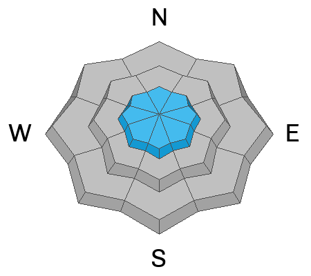
The days of green light avy danger are in the rear view and tonight's storm is gonna tip the scales-
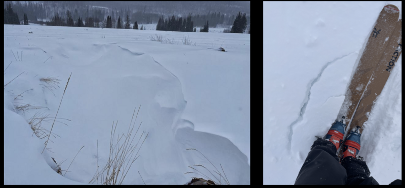
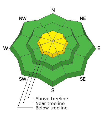
For today, MODERATE danger continues in the wind zone above treeline on steep, upper elevation slopes around the compass. Human triggered avalanches are POSSIBLE, especially on and around terrain features with recent deposits of wind drifted snow. Remember, there's no shortage of weak snow and just a little bump in wind speed will produce avalanches that break deeper and wider than we might expect.
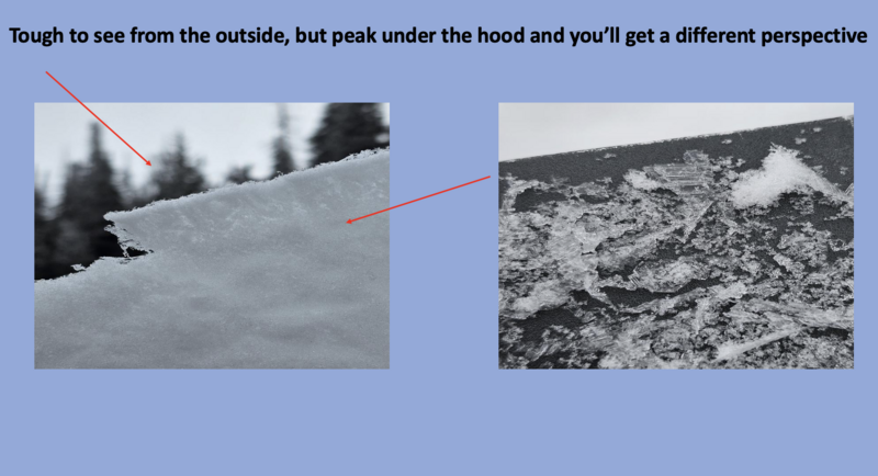
Lose the wind and you lose the problem. Great riding and generally LOW avalanche danger is found in wind sheltered terrain and at lower elevations, particularly slopes facing the south half of the compass where human triggered avalanches are UNLIKELY. Remember.... it's still thin out there so tread lightly. Slamming into a buried treasure like a rock or stump poses a greater hazard near the trailheads.
Low
Moderate
Considerable
High
Extreme
Learn how to read the forecast here
Special Announcements
Have I got an offer for you!
Sign up for forecast region-specific text message alerts. You'll get the real-deal about changing avalanche conditions, watches, and warnings.
Click HERE for more deets.
Weather and Snow
Nowcast- Yesterday's little storm slid through the region with just a breathe of wind, stacking up 5" of evenly distributed, ultra-low density snow across the range. Man... it's crisp out there this morning as skies cleared overnight, allowing temperatures to crash like a bad stock option. Deep into the graveyard shift and looking forward to weekend festivities, the mercury parties in the teens at the trailheads and single digits near the ridges. Winds blowing from the west and northwest bumped into the teens late last night, but start the new day clocking in at speeds of 5-15 mph even near the high peaks. The low density snow doesn't provide much cushion underfoot, so head to low angle slopes for the best riding and turning conditions.
Forecast- Get out and get after it this morning. Look for a brief break in between storm systems with partly cloudy skies slated for a good portion of the morning and early afternoon. High temperatures climb into the low 20's, but clouds and southwest winds bump into the 20's and 30's along the high ridges as the day wares on.
Futurecast- Now the good stuff... a cold storm crosses the region tonight into late Sunday, with snow showers lingering into Monday morning. When it's all said and done I think a foot of snow is a good bet. A break in the action is on tap for Monday with another system in the queue, slated to arrive Tuesday.
Looks like our good friends and long standing partners at the SLC NWS have a lot going on. A winter storm watch spells out active weather in the graphic above.
Recent Avalanches
It's been relatively quiet lately with no significant avalanche activity observed or reported. But if you're in the market for a list of Uinta related slides, sluffs, or slumps it's found HERE.

Trip reports and the latest observations are found HERE.
Ad
Avalanche Problem #1
Wind Drifted Snow
Type
Location
Likelihood
Size
Description
Mark and Nikki taught an avy class yesterday near Soapstone and captured the image of shallow drifting (on the left), while Trevor was in the Mill Hollow zone (on the right). Miles apart, but obs corroborate... it didn't take much wind to form sensitive, yet shallow fresh drifts around terrain features like gullies and natural depressions.
Today's most obvious avalanche dragon is the low density snow conspiring with a little bit of wind, creating touchy drifts on steep slopes above treeline. Indeed, fresh wind drifts are gonna be sensitive and react to our additional weight. Starting off shallow and predictable this morning, I bet conditions change rapidly as the storm evolves. Found mostly in the wind-zone, today you'll wanna look for and avoid fat, rounded pillows of snow and think... it's still pretty thin out there and even a small slide could take me for a body-bruising ride.
In addition, look and listen for signs of unstable snow like shooting cracks and whoomphing sounds. And remember the biggest clue to avalanches is... AVALANCHES! Yeah, if you're seeing slides on the same kinda slopes you wanna ride that's Mother Nature giving you a big heads up and delivering a Get Out of Jail free card.
Avalanche Problem #2
Persistent Weak Layer
Type
Location
Likelihood
Size
Description
Rounding the bend and quickly gaining ground is our second avalanche problem child (PWL) and it's in it to win it.
Let's face it... there's no shortage of weak surface snow formed during the December dry-spell. From near surface faceting to surface hoar it's been a fun, run with no shortage of loud pow. Left on its own accord weak surface snow is a blast to ride in, but can morph into a deceptively tricky avalanche problem when it's buried and preserved. Unfortunately, our last couple of storms slid into homeplate with very light winds, and this curve ball buried and preserved the weak snow, delivering an unusual setup for us.
Should winds bump even the slightest in velocity, avalanches will begin failing on the December drought layer. I don't think the entire range lights up in an instant. But with a series of storms headed our way, a slow burn creates increasingly tricky avy conditions as snow, water, and wind stack up and tip the scales.
Mark posted a great ob from his Moffit Peak travels Monday and explains the method of the mountain madness HERE.
Additional Information
The Uinta weather station network was upgraded this summer and all that real-time info is found HERE. Simply click on "western Uinta" tab and then "weather stations" tab.

We are always looking for snow and avalanche observations or just general riding conditions. So... if you see something, say something. You can reach me directly at [email protected] or 801-231-2170.
Also, if you're looking for more avy education opportunities for yourself, your crew, or your club please don't hesitate to reach out to me and we'll find a presentation, class, or clinic for ya!
General Announcements

Issued at 0400 on Saturday, January 6th this forecast will be updated by 0700 Sunday, January 7th, 2024.
This forecast is from the U.S.D.A. Forest Service, which is solely responsible for its content. This forecast describes general avalanche conditions and local variations always occur.
In partnership with Park City Professional Ski Patrol, I'll be delivering a state of the snowpack prezo 6:00 Thursday at the Kimball Junction Library. It'll be informative, educational, and perhaps even entertaining :)