Forecast for the Uintas Area Mountains

Mark Staples
Issued by Mark Staples for
Monday, January 8, 2024
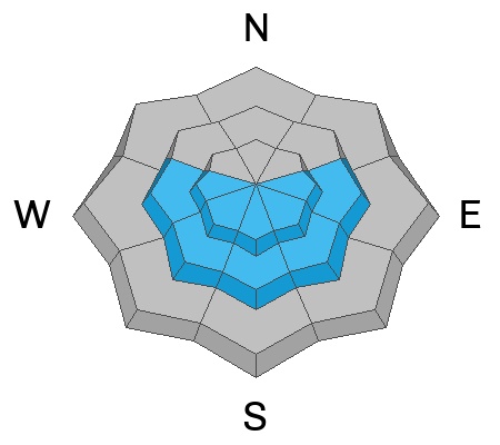
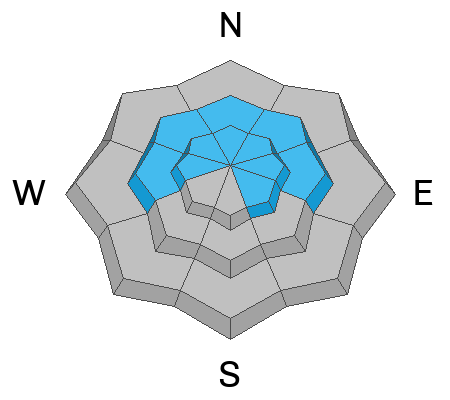
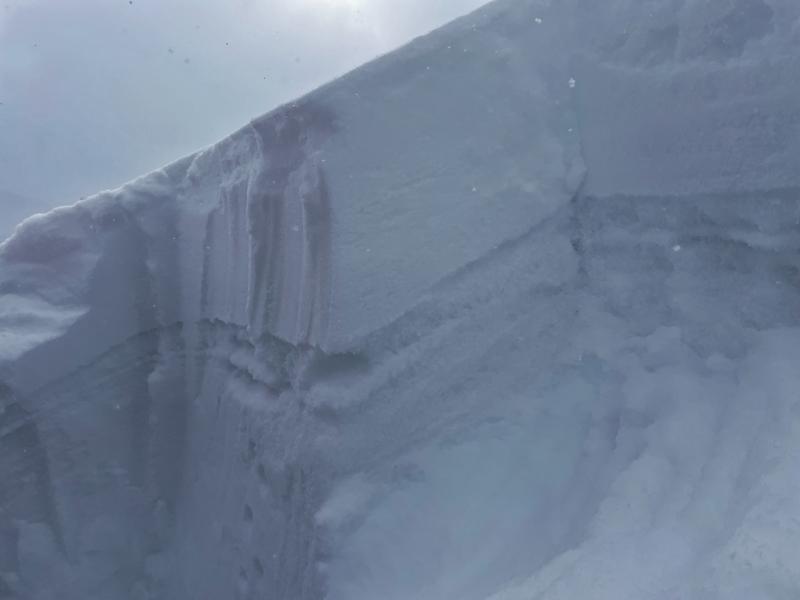
Today the avalanche danger is MODERATE near and above treeline where soft slabs of wind drifted snow and sluffs of new snow are the problems. The main strategy today is to look for and avoid fresh slabs of wind drifted snow. Also, watch for any signs like collapsing or cracking or small slab avalanches on test slopes to tell you that the new snow can produce a slab avalanche.
Low elevations below treeline with less new snow and wind have a LOW avalanche danger.
Heads up - the new snow has camouflaged all the rocks and stumps lurking just underneath.
Low
Moderate
Considerable
High
Extreme
Learn how to read the forecast here
Special Announcements
Sign up for forecast region-specific text message alerts about changing avalanche conditions, watches, and warnings.
Weather and Snow
Snowfall since yesterday morning across much of the Uintas is 2-3 inches (0.1-0.2" water) except in the Chalk Creek area that got about a foot of very low density snow (0.6" water).
Three day totals are generally 8-11 inches of snow (0.4-0.8" water) with lower amounts further east like along the Mirror Lake Highway and higher amounts in the Chalk Creek and Humpy Peak areas.
Temperatures in most places are only a few degrees above 0 F while the high peaks are below zero with dangerous wind chill values. Winds from the north increased last night and are blowing 15-25 mph this morning on the peaks and ridges with gusts up to 30 mph. Today, temperatures will struggle to break into the teens F, and winds from the north should ease just a little. Skies will have some sunshine and a few lingering clouds.
The forecast snapshot from the National Weather Service says it all - cold and snowy! There are two storms we're watching: one Tuesday night through Wednesday, and another Friday into next weekend. Strong winds arrive Tuesday evening.

There are 4 basic layers in the Uinta snowpack.
  1. On top, light fluffy snow from recent storms Jan 4-8th (10-12 inches)
  2. Very, very weak snow that faceted during dry weather in mid to late December (buried Jan 4th)
  3. A denser layer of snow from the Dec 1-3 storm.
  4. Near the ground, weak, old, faceted snow from November.
Recent Avalanches
No avalanches were reported in the Uintas yesterday; however, there were quite a few in parts of the Ogden area mountains which received a lot more snow and are a sign of things to come. View them HERE.

Latest Uinta observations are found HERE.
Ad
Avalanche Problem #1
Wind Drifted Snow
Type
Location
Likelihood
Size
Description
Avalanches today will most likely happen where winds from the north have drifted snow and formed fresh wind slabs. Look for rounded pillowy wind drifts and avoid them in steep terrain.
Yesterday on Strawberry Peak, my field partner and I only found wind effects near and above treeline. Winds were mostly filling in old tracks, but the increases in northerly winds overnight likely moved a bit more snow.
Avalanche Problem #2
Persistent Weak Layer
Type
Location
Likelihood
Size
Description
The snowpack in the Uintas is on the cusp of seeing a widespread avalanche cycle on a persistent weak layer of facets that formed on the old snow surface in December and buried on Jan 4th. You can easily see how weak this layer is in the photo below. In most places, the new snow is just too fluffy produce slab avalanches and will mostly sluff like Ted found on Gold Hill on Saturday.
However, just a little wind effect or a little more stiffening of the new snow is all it needs to start avalanching as I describe in the video below. The next storm arriving Tuesday evening with strong winds from the west could change things dramatically. Also, old facets from November near the ground are also starting to feel the load of new snow and could wake up in coming days.
Photo from Strawberry Peak showing very weak facets that can barely hold up the new snow.
Additional Information
The Uinta weather station network was upgraded this summer and all that real-time info is found HERE. Simply click on "western Uinta" tab and then "weather stations" tab.

We are always looking for snow and avalanche observations or just general riding conditions. So... if you see something, say something. You can reach me directly at [email protected] or 801-231-2170.
Also, if you're looking for more avy education opportunities for yourself, your crew, or your club please don't hesitate to reach out to me and we'll find a presentation, class, or clinic for ya!
General Announcements

Issued at 0700 on Monday, January 8th this forecast will be updated by 0700 Tuesday, January 9th, 2024.
This forecast is from the U.S.D.A. Forest Service, which is solely responsible for its content. This forecast describes general avalanche conditions and local variations always occur.
In partnership with Park City Professional Ski Patrol, I'll be delivering a state of the snowpack prezo 6:00 Thursday at the Kimball Junction Library. It'll be informative, educational, and perhaps even entertaining :)