Forecast for the Uintas Area Mountains

Craig Gordon
Issued by Craig Gordon for
Tuesday, January 9, 2024
Heads up... the snowpack is at a tipping point, it's getting real, it's gonna get sketchy, and the storm cycle is just barely off to the races-
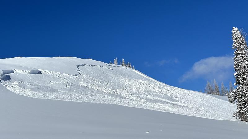
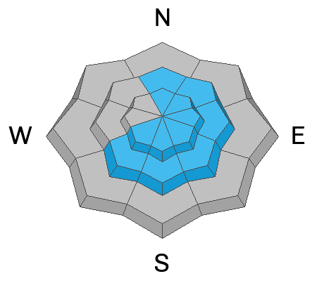
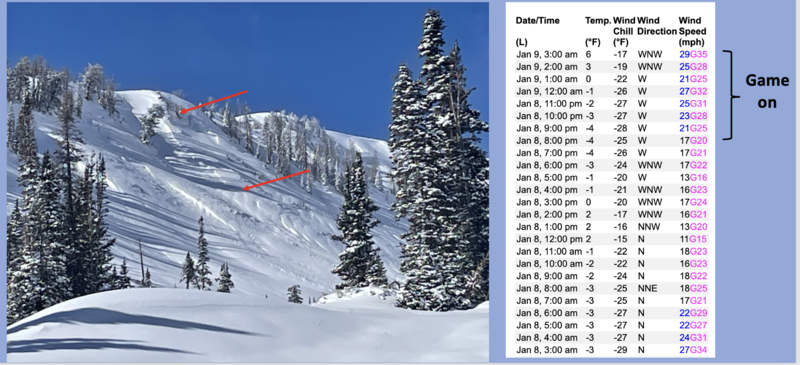
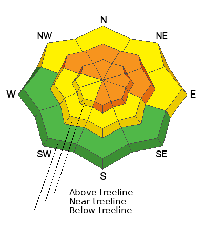
Winds ramped up overnight, changing the landscape and bumping avy danger to CONSIDERABLE. Human triggered avalanches are LIKELY, particularly in steep, leeward terrain at and above treeline, and especially in the wind zone on slopes with an easterly component to its aspect. Any avalanche triggered has the potential to break deeper and wider than you might expect... it'll pack a powerful punch.
MODERATE avalanche danger exists near the lower trailhead elevations where fresh wind drifts react to our additional weight and human triggered avalanches are POSSIBLE on steep, wind drifted slopes facing the north half of the compass.
Low elevation terrain below treeline facing the south half of the compass offers LOW avalanche danger.

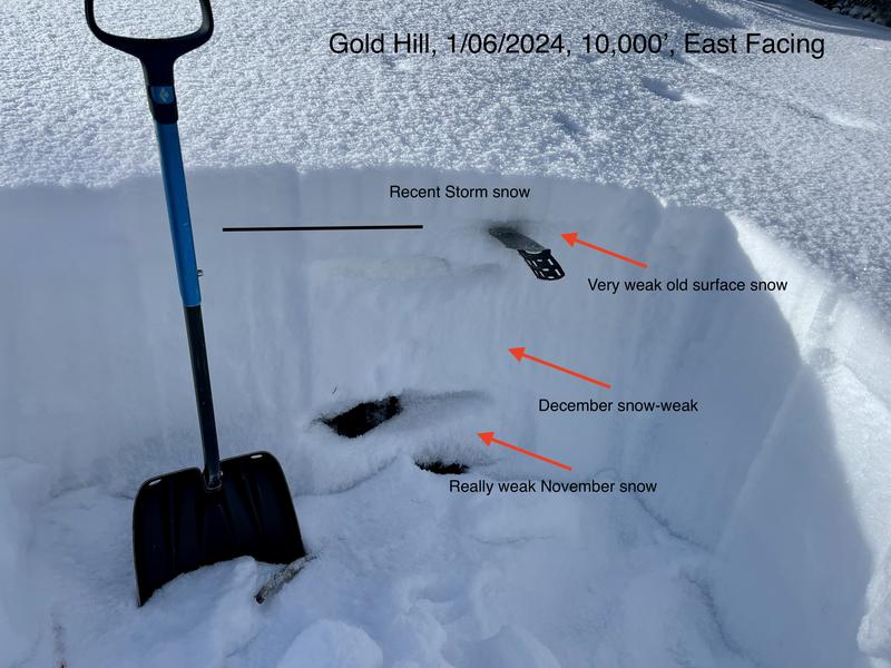
It's still lean out there and the new snow camouflages equipment trashing rocks and stumps barely lurking underneath a thin coat of white paint.
Low
Moderate
Considerable
High
Extreme
Learn how to read the forecast here
Avalanche Watch
An AVALANCHE WATCH is in effect from 6am MST this morning to 6am MST Friday for the mountains of northern and central Utah, including the Wasatch Range...Bear River Range...Uinta Mountains...and Manti-Skyline plateau.
The avalanche danger is expected to reach HIGH on Wednesday and remains elevated through the end of the week.
Strong wind and heavy snowfall will create widespread areas of dangerous avalanche conditions. Both human triggered and natural avalanches are likely. Stay off of and out from under slopes steeper than 30 degrees.
Special Announcements
Wondering what happened to the mid-pack PWL? Curious how the December dryspell will play out? Interested in what factors determine future stability trends? Well then, you came to the right place! Please join UAC forecaster Craig Gordon (that's me) at 6:00 on Thursday January 11th at the Kimball Junction library for a state of the snowpack presentation. It's guaranteed to be informative, most likely educational, and possibly even entertaining :)
Also, Sign up for forecast region-specific text message alerts about changing avalanche conditions, watches, and warnings.
Weather and Snow
Nowcast- Westerly winds ramped up overnight and currently blow in the 30's along the high ridges. High clouds drift into the region early this morning and temperatures are slightly warmer, yet still register in the single digits across the board. Upper elevation terrain is getting smoked by the wind, so your best bet for quality snow are wind sheltered mid elevation slopes.
Forecast- The first of two storm systems impact the region today, bringing a period of heavy snow and strong winds late this afternoon through early this evening. West and northwest winds blowing in the 30's steadily increase throughout the day, cranking into the 50's and 60's by about supper time. High temperatures climb into the low 20's and dip into single digits over night.
Futurecast- Storm number one kicks in late tonight, delivering a foot of snow by Wednesday morning. A brief and perhaps indistinguishable break early Wednesday, with another storm hot on its heels.
Hold onto your hats... if you wear 'em! Our good friends and longtime partners at the SLC NWS issued a Winter Storm Warning for the Uinta zone.

There are 4 basic layers in the Uinta snowpack.
  1. On top, light fluffy snow from recent storms Jan 4-8th (10-12 inches)
  2. Very, very weak snow that faceted during dry weather in mid to late December (buried Jan 4th)
  3. A denser layer of snow from the Dec 1-3 storm.
  4. Near the ground, weak, old, faceted snow from November.
Recent Avalanches
This slide triggered on Yamaha Hill yesterday, broke into weaker midpack snow and is a sign of things to come with more snow and wind on the way!
More Uinta avy activity found HERE

Latest Uinta observations are found HERE.
Ad
Avalanche Problem #1
Wind Drifted Snow
Type
Location
Likelihood
Size
Description
A 24 hour wind run from Windy Peak (10,066') clearly illustrates the overnight uptick in winds.
Find the wind and you find the problem. Winds have been all over the map the past few days and there's not shortage of light, fluffy snow available to blow around and form drifts, sensitive to our additional weight. Today, we need to look for and avoid fresh wind drifts on the leeward side of ridges and around terrain features like chutes and gullies. Once initiated, even a small avalanche can get quickly out of hand as it crashes onto the slope below.
Avalanche Problem #2
Persistent Weak Layer
Type
Location
Likelihood
Size
Description
The biggest clue to avalanches is ???... AVALANCHES! In shallow snowpack zones we are already seeing natural avalanche activity and the slides are failing on the persistent weak layer (PWL) formed during the December dryspell. Without any wind it's just fluff on fluff, but Sunday nights uptick in wind speeds stiffened the snow surface, giving it just enough body to form soft slabs on isolated terrain features. This mornings wind changes the game, creating a stiff, cohesive piece of snow that's resting on weak, sugary snow.... no bueno!

Additional Information
The Uinta weather station network was upgraded this summer and all that real-time info is found HERE. Simply click on "western Uinta" tab and then "weather stations" tab.

We are always looking for snow and avalanche observations or just general riding conditions. So... if you see something, say something. You can reach me directly at [email protected] or 801-231-2170.
Also, if you're looking for more avy education opportunities for yourself, your crew, or your club please don't hesitate to reach out to me and we'll find a presentation, class, or clinic for ya!
General Announcements

Issued at 0430 on Tuesday, January 9th this forecast will be updated by 0700 Wednesday, January 10th, 2024.
This forecast is from the U.S.D.A. Forest Service, which is solely responsible for its content. This forecast describes general avalanche conditions and local variations always occur.