Forecast for the Uintas Area Mountains

Craig Gordon
Issued by Craig Gordon for
Wednesday, January 10, 2024
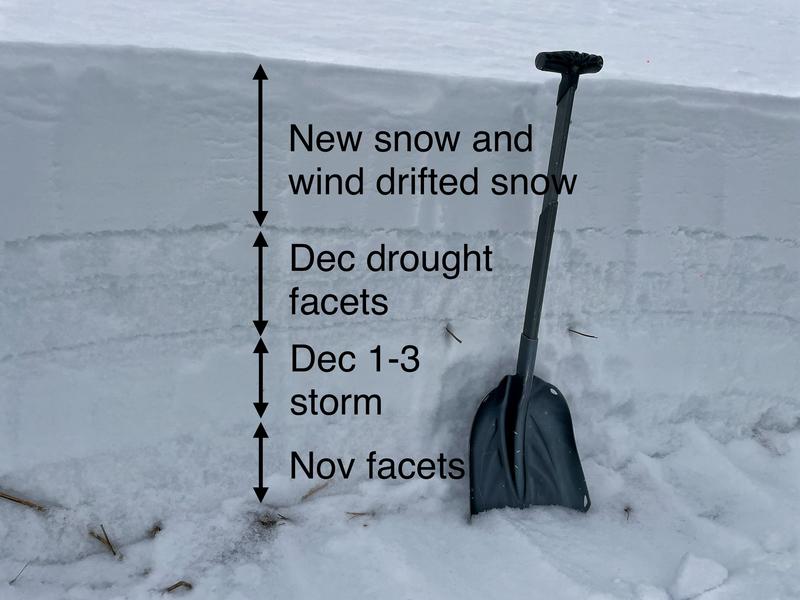
Heads up... yesterday's cow-tipping winds and storm snow created deceptively dangerous avalanche conditions-
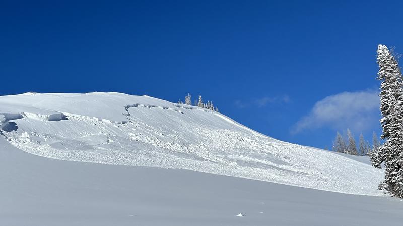
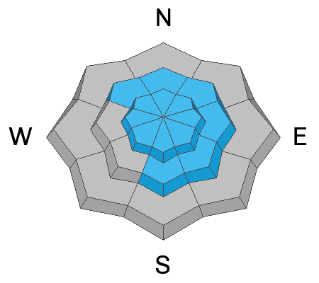
Recent landscape changing winds bumped the avy danger to HIGH. Both human triggered and natural avalanches are VERY LIKELY, particularly in steep, leeward terrain above treeline, and especially in the wind zone on slopes with an easterly component to its aspect. Any avalanche triggered has the potential to break deeper and wider than you might expect... it'll pack a powerful, season ending punch.
Wind penetrated mid elevation terrain where you'll find CONSIDERABLE avalanche danger. Human triggered avalanches are LIKELY on steep wind drifted slopes.
MODERATE avalanche danger exists near the lower trailhead elevations where fresh wind drifts react to our additional weight and human triggered avalanches are POSSIBLE.

It's still lean out there and the new snow camouflages equipment trashing rocks and stumps barely lurking underneath a thin coat of white paint.
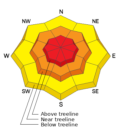
Low
Moderate
Considerable
High
Extreme
Learn how to read the forecast here
Avalanche Warning
An AVALANCHE WARNING is in effect from 6am MST this morning to 6am MST Thursday, for the mountains of northern and central Utah, including the Wasatch Range...Bear River Range...Uinta Mountains...and Manti-Skyline plateau.
The avalanche danger is HIGH today.
Strong winds and heavy snowfall have created widespread areas of dangerous avalanche conditions. Both human triggered and natural avalanches are likely. Please stay off of and out from under slopes steeper than 30°.
Special Announcements
Wondering what happened to the mid-pack PWL? Curious how the December dryspell will play out? Interested in what factors determine future stability trends? Well then, you came to the right place! Please join UAC forecaster Craig Gordon (that's me) at 6:00 on Thursday January 11th at the Kimball Junction library for a state of the snowpack presentation. It's guaranteed to be informative, most likely educational, and possibly even entertaining :)
Also, Sign up for forecast region-specific text message alerts about changing avalanche conditions, watches, and warnings.
Weather and Snow
Nowcast- Last night's cold front blasted through northern Utah like a cross-fire hurricane and delivered nuking winds, cold air, and yes.... thunder snow! Automated snow sites across the range report 8" of snow with .60 H2O. Looks like a few, favored foothill locations might've squeezed out a little more juice. In any case, winds blow from the west 30-50 mph along the high ridges and temperatures register in the single digits. Wind chill values hover right around -30 degrees.... ouch. Upper elevation terrain is getting smoked by the wind, so your best bet for quality snow are wind sheltered mid and low elevation slopes.
Forecast- Look for a short break in the action this morning with mostly cloudy skies and a few scattered snow showers. Westerly winds are gonna be obnoxious, blowing in the 30's, gusting into the 50's and 60's near the high peaks. It'll feel like winter with high temperatures barely clawing their way into the mid teens. Another storm system slides through late this afternoon or early evening. Expect a blast of heavy snow with a foot for Thursday morning.
Futurecast- Stormy through the end of the work week, but the hammer really comes down over the weekend! I'll have more deets on strength and timing for tomorrow's update :)
Hold onto your hats... if you wear 'em! Our good friends and longtime partners at the SLC NWS issued a Winter Storm Warning for the Uinta zone.

Visiting LaSal area forecaster Eric Trenbeath braved yesterday's storm, crossed county lines, and joined Mark Staples for a Currant Creek stomp around yesterday. Their most excellent observation is found HERE.
There are 4 basic layers in the Uinta snowpack.
  1. On top, a dense wind slab whipped up by yesterday's storm
  2. Very, very weak snow that faceted during dry weather in mid to late December (buried Jan 4th)
  3. A denser layer of snow from the Dec 1-3 storm.
  4. Near the ground, weak, old, faceted snow from November.
Recent Avalanches
This slide triggered on Yamaha Hill Monday, broke into weaker midpack snow and is a sign of things to come with more snow and wind on the way!
More Uinta avy activity found HERE

Latest Uinta observations are found HERE.
Ad
Avalanche Problem #1
Wind Drifted Snow
Type
Location
Likelihood
Size
Description
Mark's pit test reveals our current setup.
Find the wind and you find the problem. Winds have been all over the map the past few days and there's not shortage of light, fluffy snow available to blow around and form drifts, sensitive to our additional weight. Today, we need to look for and avoid fresh wind drifts on the leeward side of ridges and around terrain features like chutes and gullies.
Avalanche Problem #2
Persistent Weak Layer
Type
Location
Likelihood
Size
Description
The biggest clue to avalanches is ???... AVALANCHES!
In the early morning hours Monday, shallow snowpack zones came to life with just a little hint of wind. In fact, slabs triggered by natural cornice fall, began tearing away from steep terrain. But that was so 48 hours ago and it is yesterday's cow-tipping winds that said... "game on, let's create a stiffer, more cohesive piece of snow." Yeah... it's strong snow resting on a Gong Show of weak, old, sugary snow, or in snow-geek-speak... the persistent weak layer (PWL) formed during the December dryspell. Whatever your classification, know that once triggered, any avalanche breaking into older snow will get out of hand quickly... no bueno!
s

Additional Information
The Uinta weather station network was upgraded this summer and all that real-time info is found HERE. Simply click on "western Uinta" tab and then "weather stations" tab.

We are always looking for snow and avalanche observations or just general riding conditions. So... if you see something, say something. You can reach me directly at [email protected] or 801-231-2170.
Also, if you're looking for more avy education opportunities for yourself, your crew, or your club please don't hesitate to reach out to me and we'll find a presentation, class, or clinic for ya!
General Announcements

Issued at 0430 on Wednesday, January 10th this forecast will be updated by 0700 Thursday, January 11th, 2024.
This forecast is from the U.S.D.A. Forest Service, which is solely responsible for its content. This forecast describes general avalanche conditions and local variations always occur.