Forecast for the Salt Lake Area Mountains

Trent Meisenheimer
Issued by Trent Meisenheimer for
Sunday, April 7, 2019
This morning the avalanche danger is LOW. However, it will quickly rise to MODERATE with day time heating allowing for wet loose avalanches at all elevations and aspects. Keep an eye on the snow surface to see if it's becoming wet, damp and loose. If the snow surface is hard and dry then it will remain a LOW avalanche danger in those locations.

There remains the chance is specific areas for very large glide avalanches to occur.
Low
Moderate
Considerable
High
Extreme
Learn how to read the forecast here
Special Announcements
Grizzly Gulch will be closed on Monday April 8th and Tuesday April 9th as Alta conducts rescue training. Please give these rescue workers the space they need.

Summer is a busy time for the UAC working on our fall and winter planning, putting together the Fall Fundraiser and the Utah Snow and Avalanche Workshop (USAW), and updating our education programs. In addition, this summer we will be finishing up the website redesign project. Your donation shows you’re invested in this community all year round! You can still be part of the UAC’s success in 2019.
Weather and Snow
Under clear skies the overnight temperatures dropped into the mid twenties above about 7,400' allowing the snowpack to have a decent refreeze. Below 7,400' the temperatures hovered around 32°F. The Park City side as well as Millcreek overnight temps did not drop like in the Cottonwoods and many stations around 8,300' were only dropping into the low 30's °F allowing for a poor refreeze at these elevations.
Winds are currently blowing from the westerly direction at speeds of 10-15 mph gusting into the low 20's at upper elevations. These westerly winds are ushering in some mid to high level clouds for the morning hours before clearing out in the afternoon giving way to sunny skies. Temperatures will rise into the mid 40's °F at 8,500' by mid afternoon.
Yesterday, I said to my partners this was the worst day of the season (powder snob). However, the mountain views, swirly fog, mist, and the good company was 5 stars. Even the upper elevation northerly facing slopes were wet and saturated and riding through this snow took effort. Railroading, mank, glop, sticky, heavy, awful, were all terms used during yesterday's outing. My best guess is it would be possible to find dry settled powder snow on due north facing slopes above about 10,000'.
Each week Greg Gagne puts together "The Week in Review" can be found by clicking here. It's a great way to remember what the past week has been like and how we got here.
Recent Avalanches
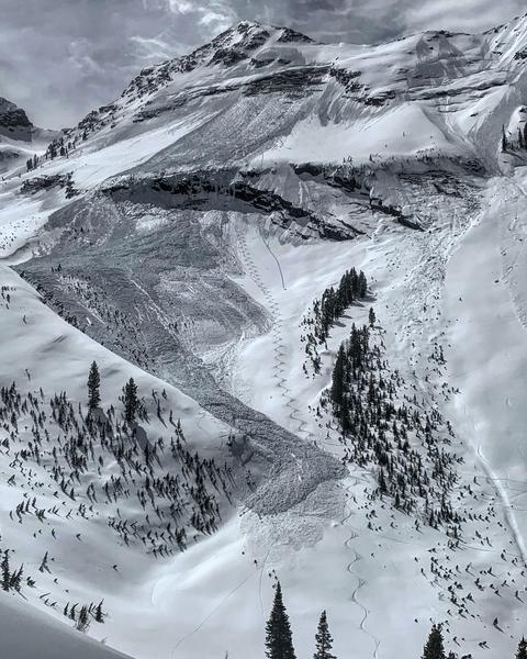
Yesterday, backcountry observers took note of the easily triggered wet loose avalanches. Most of these were small in size and easily avoidable. However, my group did trigger one wet loose slide on a steep 40° degree NE facing slope at 9,400' in elevation. This avalanche was triggered by a skier doing a slope cut across the top of the rollover. It was large enough to catch, carry and bury you as the debris piled up 3-5' deep against the trees (picture below).
Ad
Avalanche Problem #1
Wet Snow
Type
Location
Likelihood
Size
Description
The main concern for today will be wet avalanches. This morning the snowpack will be frozen and by the afternoon it will become damp and loose once again. Avoid being in and on steep terrain when the snowpack becomes damp and wet. This problem is easy to avoid as you can see when the snowpack become wet and unsupportable. Be mindful of your alpine exits as many of the descents require you to be in steep terrain traps with lots of snow hanging above you.
Video: Having a little fun with wet loose avalanches from yesterday.
Avalanche Problem #2
Gliding Snow
Type
Location
Likelihood
Size
Description
In specific places, the entire snowpack glides downhill and can release at unpredictable times. Before releasing, the snowpack produces large, visible cracks in the snow which tell us where these avalanches can occur. They often happen where the snowpack rests on top of rock slabs or other smooth ground surfaces.
Common places to find these cracks and the resulting glide avalanches are Broads Fork, Stairs Gulch, and Mill B South of BCC, upper Porter Fork (Raymond Slabs), as well as one spotted on Cardiac Ridge. Knowing when they will occur is very tough. Knowing where they will occur is easy because they typically produce large cracks prior to avalanching.
Photo of glide avalanche in Broads Fork (M. White).
Additional Information
There is a potent storm slated to crash into the Wasatch range beginning on Tuesday with the return of winter. Snow will be brought down to the valley floors with significant snow in the mountains. The atmospheric department at the University of Utah has these cool plumes to check out. These are ensemble model runs of what we could see out of the storm with water and snow amounts. This plot is for upper LCC.
General Announcements
This information does not apply to developed ski areas or highways where avalanche control is normally done. This forecast is from the U.S.D.A. Forest Service, which is solely responsible for its content. This forecast describes general avalanche conditions and local variations always occur.