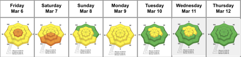
Forecast for the Salt Lake Area Mountains

Brooke Maushund
Issued by Brooke Maushund on
Sunday morning, March 15, 2026

The avalanche danger is LOW and the snowpack is generally stable. Travel in the mountains is inherently risky, so Normal Caution is advised.

The buried PWL (persistent weak layers) are mostly dormant and triggering one of these is unlikely but not impossible. Continue to avoid glide avalanche terrain such as Stairs, Broads, Mill B South, and upper Porter Fork.

Low
Moderate
Considerable
High
Extreme
Learn how to read the forecast here
Special Announcements

Spring Campaign and Spring Auction - Each spring, we ask for your continued financial support to fund our forecasting and education programs. We hope you will consider supporting our mission by checking out our campaign and auction, live and available HERE.

Weather and Snow

Yesterday, the morning started out warm with temps rising to the high 30s F before a cold front moved in. Light showery precipitation started in the mid-afternoon, ahead of frontal passage later in the evening. The front cranked winds from the W up to the 60s mph, with gusts hitting over 105 mph on the highest ridgelines last night and dropping temps to single digits. The snowpack saw its first decent refreeze in over 2 nights. Trace amounts of snow and graupel fell, with favored areas receiving 2-4 inches and less than 0.1 inch of water.

This morning, temperatures are brisk in the single digits F—maybe for the last time this season. Winds are steady in the 60s on Hidden Peak, with other stations in the 20s-30s mph. For the rest of the day, we can expect slightly decreasing winds under partly cloudy skies, with highs in the low to mid 20s F.

Looking ahead, a mid-March heat wave hits the Central Wasatch this next week, as temperatures are forecast to creep into the 60s F (!) in the mountains and 80s F in the valley. Yikes. While a mid-March warm-up like this isn't "normal" (what is anymore?), what is truly irregular is this heat combined with our poor snowpack structure. Keep checking back for daily forecasts if you plan to ski or ride through the week—we aren't done with avalanches yet. More are coming...and they'll probably at least be weird, if not surprising.

The Week in Review is Hot off the Press - Click HERE

Recent Avalanches

Glide avalanche Blue Ice (NE, 10300') on Friday: Grainger, Young, & Anderson watched a 5' deep, 100' wide glide avalanche release.

You can find more observations from the Salt Lake zone HERE.

Avalanche Problem #1
Normal Caution
Type
Location
Likelihood
Size
Description

It is always best to follow safe travel practices regardless of the avalanche danger: cross slopes one at a time, be aware of who is above and below you, and keep an eye on your partner.

New snow: While it's unlikely to find heavy accumulation, be on the lookout for deposits of new snow that can run far and fast on slick old surfaces.

Wind-drifted snow: Be aware of small, pockety, mostly old hard wind slabs in isolated, rocky high alpine terrain. You may be able to find very small accumulations of new snow on slopes that face N-E-S.

Cornices tend to calve naturally during the springtime. Avoid being on or beneath these ridgeline hazards.

Persistent weak layer (PWL) was dropped as a problem yesterday, but keep it at the forefront of your mind in steep, unsupported, extreme northerly terrain. More on that below.

Glide avalanches have been releasing naturally in the past week, like in Broads on Friday. These full-depth and destructive slides are difficult to forecast and it's worth avoiding known habitat (on steep and smooth quartzite slabs) and their runouts in areas such as Stairs, Broads, and Mill B South of Big Cottonwood Canyon, and upper Porter Fork in Mill Creek.

Additional Information

What does it mean to drop the PWL?


Graphic courtesy of Joe Stock's 2024 piece in The Avalanche Review.

You'll notice that we dropped the persistent weak layer (PWL)—that's responsible for 4 deaths since mid-February—as a problem yesterday. What we want you to know is that there is a fair bit of uncertainty around dropping a PWL from the forecast. We don't drop a PWL because it's impossible to trigger. In fact, it is literally impossible to be 100% certain that there is not a single lingering weakness. As seen in the graphic, a PWL comes with an inherently higher amount of uncertainty, as do glide avalanches—like the one that ran in Broads yesterday. Know as you travel today that uncertainty lingers in the mountains—and we deal with uncertainty by adding margins. Visiting avalanche pro Lisa Van Sciver put it well in her ob when she wrote, "While the snowpack in this is area is generally stable, in extreme terrain especially unsupportable slopes this structure should be considered..."

Uncertainty is a tough thing to communicate in avalanche forecasting; that's why multiple PhDs are studying it. An important finding so far is that explicitly stating our uncertainty in our forecasts increases trust in the avalanche center. So know: we have some surrounding the PWL. As temps skyrocket next week, know you may find it coming back into the forecast.

General Announcements

This information does not apply to developed ski areas or highways where avalanche control is normally done. This forecast is from the U.S.D.A. Forest Service, which is solely responsible for its content. This forecast describes general avalanche conditions and local variations always occur.