Donate to Our Spring Campaign or Bid on our Spring Auction to Support Forecasting

Forecast for the Salt Lake Area Mountains

Dave Kelly
Issued by Dave Kelly on
Saturday morning, March 15, 2025
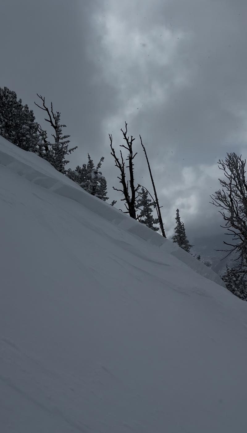
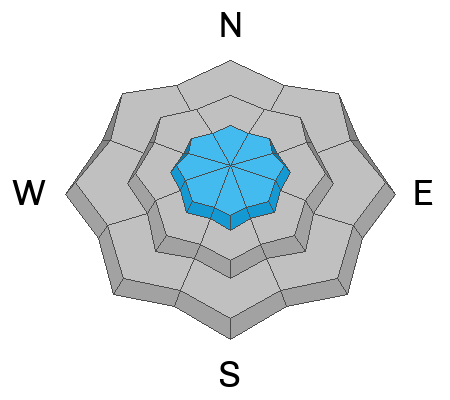
There is a CONSIDERABLE avalanche danger in upper-elevation terrain where you are likely to trigger a new or wind-drifted snow avalanche that could be up to 2' deep and 150' wide. The avalanche danger is MODERATE at the mid-elevations and LOW in the lower elevation terrain where it will be less likely to trigger a wind-drifted snow avalanche, but still possible to trigger a soft slab avalanche failing in the newest snow.
Look for and avoid areas of wind-drifted snow such as pillowy, rounded slopes, or ridgeline features with new cornices. Only expose one traveler at a time to steep slopes (greater than 30°) and practice good travel protocols being aware of who may be below you before working into steeper terrain.
Low
Moderate
Considerable
High
Extreme
Learn how to read the forecast here
Special Announcements
Our Spring Campaign is in full swing, and there are two great ways to support forecasting, awareness, and education across Utah: Donate to our Spring Campaign, or Bid on items in our Spring Auction. Every dollar donated helps keep the backcountry community on top.
Weather and Snow
Currently, under overcast skies it is snowing lightly. Temperatures are in the teen's °F at most weather stations and winds are blowing from the west at the lower ridgelines in the teens and from the west-northwest at the highest ridgelines in the 30's gusting to the 50's MPH. Some weather stations at the highest ridgelines may be rimed and showing lower wind speeds. We have had anywhere from 3" to 8" of snow in the last 24-hours which brings storm totals to 15"-30" of snow and 1.25"-2.25" of water weight and some places have had over 7' of snow and 6.5" of water since the first of March.
For today, under mostly cloudy skies look for temperatures to be 26-30°F. Winds will blow from the west at the lower ridgelines 10 gusting to 15 MPH and from the west-northwest 35 gusting to 45 MPH at the highest ridgelines. Look for 4"-8" of new snow with .40"- .60" of water during the day. There could be periods of increased snowfall rates of up to 1" an hour with the chance of lightning. If this were the case then some areas could hit the higher end of snowfall numbers if not go over.
The trick in March is to get the new snow before the sun does regardless of air temperatures.
Recent Avalanches
Yesterday, we had reports of new and wind-drifted snow avalanches in the Central Wasatch. The deeper avalanches involved wind-drifted snow, and there were reports of soft slab avalanches running on a density change during the day.
Some highlights include: Southeast facing LCC, Twin Lakes, Dog Lake, Argenta, God's Lawnmower and in Greaseball.
Check out all recent avalanches and observations HERE.
Photo (ERrubble) of a wind-drifted snow avalanche on Kessler Peak
Ad
Avalanche Problem #1
Wind Drifted Snow
Type
Location
Likelihood
Size
Description
There is new snow at all elevations that is primed for transport. While wind-drifted snow will be a bigger issue in the higher elevation terrain don't discount seeing shallow soft drifts in mid-elevation terrain. If you see cracking, feel collapsing, or see signs such as new cornices or pillowy wind loaded features then avoid traveling on or underneath these areas of wind-drifted snow.
Avalanche Problem #2
New Snow
Type
Location
Likelihood
Size
Description
Do not be surprised to see or trigger shallow new snow avalanches failing on density changes within the storm snow. These new snow avalanches may only be 6"-10" deep, but in steep terrain with a long vertical run this could entrain more than enough snow to bury a person.
With any hint of March sun even for a moment, regardless of air temperatures we could see wet loose rollerballs, roof slides, and form a crust on the snow surface. Yesterday there were reports of a slight crust on south and east facing aspects which may not have bonded well with last night's snow. Check out the new/old snow interfaces as you're traveling before committing to being under or traveling in steep avalanche terrain.
These are the kind of avalanches that may impact more than your group, so please be aware of who may be traveling below or above you while you're out and about.
Avalanche Problem #3
Persistent Weak Layer
Type
Location
Likelihood
Size
Description
The chance of triggering an avalanche failing on a deeper buried layer of facets near the ground is diminishing with time. The first layer of facets now buried near the ground is most likely to be triggered in thinner spots on northwest-north-east facing mid and upper-elevation aspects. The second persistent weak layer (PWL) is a thin dust layer that formed and was buried in early March and is now buried 2'-3' deep. This dusty layer will be easy to identify and recent test results have showed propagation becoming more difficult on this layer.
This most recent storm is great test of both of these layers and while I don't trust that these layers are gone, I think that we're turning the corner on this season of persistent weak layers.
Additional Information
Be sure to catch up on significant weather and avalanche events with Nikki's Week in Review:
General Announcements
This information does not apply to developed ski areas or highways where avalanche control is normally done. This forecast is from the U.S.D.A. Forest Service, which is solely responsible for its content. This forecast describes general avalanche conditions and local variations always occur.