Donate to Our Spring Campaign or Bid on our Spring Auction to Support Forecasting

Forecast for the Salt Lake Area Mountains

Dave Kelly
Issued by Dave Kelly on
Sunday morning, March 16, 2025
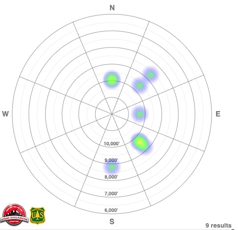
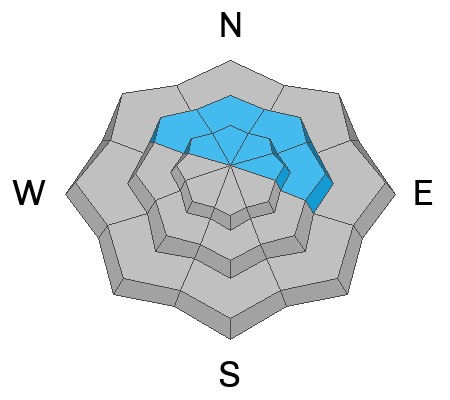
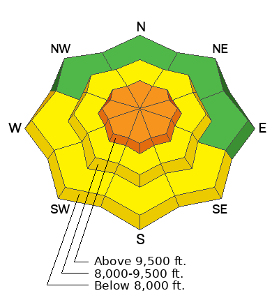
There is a CONSIDERABLE avalanche danger in upper-elevation terrain where humans are likely to trigger a new or wind-drifted snow avalanche that could be up to 2' deep and 150' wide. The avalanche danger is MODERATE at the mid-elevations and on south facing low elevations where natural avalanches are less likely, but human triggered avalanches are possible.
The catch today will be whether the warm March sun or the wind has more effect on the snow surface. Prepare to adapt your tour plan based on your observations and be on the lookout for and avoid wind-drifted snow problems at higher elevations and wet snow at mid and low elevations.
Only expose one traveler at a time to steep slopes (greater than 30°) and practice good travel protocols being aware of who may be below you before working into steeper terrain.
Low
Moderate
Considerable
High
Extreme
Learn how to read the forecast here
Special Announcements
Our Spring Campaign is in full swing, and there are two great ways to support forecasting, awareness, and education across Utah: Donate to our Spring Campaign, or Bid on items in our Spring Auction. Every dollar donated helps keep the backcountry community on top.
Weather and Snow
Currently, under partly cloudy skies temperatures are in the mid teen's °F. Winds are blowing from the southwest in the teen's gusting to the 20's MPH at the lower ridgelines and in the 20's gusting to the 30's at the higher ridgelines. We have had 5" to 19" of snow in the last 24-hours which brings storm totals to 24"-48" of snow and 1.50"-3.25" of water weight and some locations have had over 8' of snow and 7.5" of water since the first of March.
Today, look for partly cloudy skies with light snow possible. Temperatures will rise to the low 40's °F. Winds will blow from the southwest at the lower ridgelines 20 gusting to 30 MPH and at the highest peaks 35 gusting to 45 MPH and increasing in speed later this afternoon with gusts into the 60's MPH.

This time of year, the catch is to get the new snow before the sun does regardless of air temperatures.
Recent Avalanches
Yesterday, there were a number of avalanches reported to the Utah Avalanche Center involving new and wind-drifted snow. These were mostly shallow soft slab avalanches, but anywhere they were able to entrain more snow they packed a punch. There is an excellent write up of a close call in the Memorials HERE, that is representative of what you may find on steep aspects where the snow is able to gather some steam on its way down the mountain. Forecaster Greg Gagne put together some thoughts on traveling through the mountains in his observation from Mill Creek HERE.

Avalanche Heat Rose showing reported activity from the Salt Lake Region from yesterday.

Check out all recent avalanches and observations HERE.
Ad
Avalanche Problem #1
Wind Drifted Snow
Type
Location
Likelihood
Size
Description
There is new snow at all elevations that is primed for transport. With increased wind speeds at the mid and upper elevations today you may see drifting snow lower on the slope than you expect. Keep an eye out for cracking, collapsing, new cornice buildup or pillowy wind loaded features. If you see these signs then avoid traveling on or underneath slopes with wind-drifted snow.
Avalanche Problem #2
New Snow
Type
Location
Likelihood
Size
Description
Do not be surprised to see or trigger shallow new snow avalanches failing on density changes within the storm snow. These new snow avalanches may only be 6"-10" deep, but in steep terrain with a long vertical run this could entrain more than enough snow to bury a person.
The March sun is strong. Regardless of air temperatures and wind speeds we could see wet loose avalanches, roof slides, and get a gloppy snow surface at lower elevations on all aspects. Check out the new/old snow interfaces before committing to being under or traveling in steep avalanche terrain.
These are the kind of avalanches that may impact more than your group, so please be aware of who may be traveling below or above you while you're out and about.
Avalanche Problem #3
Persistent Weak Layer
Type
Location
Likelihood
Size
Description
The chance of triggering an avalanche failing on a deeper buried layer of facets near the ground is diminishing with time. The first layer of facets now buried near the ground is most likely to be triggered in thinner spots on northwest-north-east facing mid and upper-elevation aspects. The second persistent weak layer (PWL) is a thin dust layer that formed and was buried in early March and is now buried 2'-3' deep. This dusty layer will be easy to identify and recent test results have showed propagation becoming more difficult on this layer.
This most recent storm is a great test of both of these layers and while I don't trust that these layers are gone, I think that we're starting to turn the corner on this season of persistent weak layers.
Additional Information
Be sure to catch up on significant weather and avalanche events with Nikki's Week in Review:
General Announcements
This information does not apply to developed ski areas or highways where avalanche control is normally done. This forecast is from the U.S.D.A. Forest Service, which is solely responsible for its content. This forecast describes general avalanche conditions and local variations always occur.