Forecast for the Salt Lake Area Mountains

Drew Hardesty
Issued by Drew Hardesty for
Sunday, March 13, 2022
Areas of CONSIDERABLE avalanche danger exist on steep west to north to east facing aspects of all elevations. These are dangerous, unmanageable avalanches 2-4' deep and a couple hundred feet wide. Know that you can trigger these from a distance. A MODERATE danger exists for shallow wind drifts and new snow instabilities at the mid and upper elevations.
Low
Moderate
Considerable
High
Extreme
Learn how to read the forecast here
Weather and Snow
Skies are partly cloudy with a quick hitting storm on the horizon. Ahead of the storm, mountain temperatures are in the mid to upper 20s. Winds backed to the southwest overnight and are blowing 15-20mph with gusts to 35. Gusts exceed 60mph along the highest ridgelines. Snowfall should begin mid-morning with 4-8"+ expected by evening. Clearing for tomorrow with another storm slated for Tuesday night into Wednesday.
For today, we'll see snow, heavy at times, with temperatures dropping to the upper teens and low 20s. Winds will veer to the west northwest post frontal and remain breezy, blowing 20mph with gusts to 40.

Greg Gagne's Week in Review is published and can be found HERE.
Recent Avalanches
In 
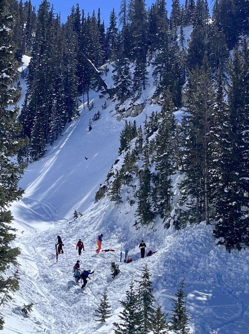
Silver Fork of BCC, a skier was caught, carried, and fully buried six feet deep for over 20 minutes yesterday. Thanks to the rescue efforts of his party, he was recovered breathing but unconscious and later flown to a hospital in town as in "stable, but critical condition". Our preliminary report is HERE>. Thanks to the efforts of SL County SAR, WBR, Solitude and Snowbird ski patrol teams, Powderbird, Life Flight, and others. The avalanche was on a steep northeast facing slope at 9300'. The avalanche was estimated at 2.5' deep and 150' wide. Photo below.
At roughly the same time, a lone skier just down canyon was caught, carried, and partially buried to his waist in a 20" deep and 125' wide avalanche in Mats Basin. He was carried 300' down the path, lost gear, but was able to get out on his own. The avalanche was on a steep north facing slope at 8800'.
Another party in Silver Fork reported triggering a soft slab on their exit from West Bowl. The slide was estimated 6"-3' deep on a steep north facing rollover at 9400'.
Further down BCC in Mineral Fork, a party unintentionally triggered a 2' deep and 70' wide soft slab while descending East Mineral. This avalanche was on a north facing pitch at 10,200'.
Last, but not least, Park City ski patrol noted that Scott Peak (a slope out of bounds to the north) ran naturally 2-3' deep and 800' wide. This avalanche is a repeater, having avalanched in January. This is a steep wind-loaded slope, overhung with cornices. It faces northeast at 9700' there along the PC ridgeline.
The only significant wet avalanche activity was reported cascading over the Hellgate cliffs in LCC.
ALL of these can be found in Observations and Avalanches in the Menu above.

I have a short new blog post about accidents. It's called Deus Ex Machina.
Ad
Avalanche Problem #1
Persistent Weak Layer
Type
Location
Likelihood
Size
Description
Dangerous avalanches can still be triggered 2-4' down on our Jan/Feb drought layer of facets. These avalanches are likely on steep west to north to easterly facing slopes at all elevations. It should be noted that many very experienced people have had very close calls in the past few days. It's worth stepping back from the edge here, folks and sticking to low angle terrain with no overhead hazard.
ALL the red flags are there: Avalanches, Collapsing, Cracking, Poor Snowpack Structure, Recent Heavy Snowfall, Wind Drifting.
Travel Advice: Avoid being on or below steep slopes facing west to north to east on all elevations. We say below because you can trigger these avalanches from below the steep slope.
A few words of caution:
  • Signs of instability may not always be present: you may or may not see or experience shooting cracks or audible collapsing.
  • Tracks on the slope offer zero signs of stability. Avalanches will take out multiple existing tracks.
  • You can trigger these avalanches from a distance or below.
  • Another unusual thing is that many of these dangerous avalanches have occurred along the lower elevation bands (at and below 8000') (Example)
Avalanche Problem #2
Wind Drifted Snow
Type
Location
Likelihood
Size
Description
Fresh wind drifts will be found primarily on steep northwest to north to east facing slopes today and may be surprisingly sensitive, failing on areas of surface hoar and new weaknesses along the surface of the recent storm snow.
Avalanche Problem #3
New Snow
Type
Location
Likelihood
Size
Description
The new snow should bond poorly to the old snow surfaces, particularly on sheltered shady aspects. Sluffing may be expected with shallow soft slabs possible during periods of high snowfall.
Additional Information
FORECASTER'S CORNER: I know you're hungry. So am I. January and February were among the driest on record and now the powder is excellent. But here's the thing: the powder will also kill you in steep terrain. Trust me. Very experienced people have been surprised in recent days. The skiing and riding is still good on low angle terrain. Wait for a bit and let it settle out.

Blog on "Our Jan/Feb Drought Layer and PWL Summary of Avalanche Activity on This Layering for the Central Wasatch Range." HERE.
General Announcements
Who's up for some free avalanche training? Get a refresher, become better prepared for an upcoming avalanche class, or just boost your skills. Go to https://learn.kbyg.org/ and scroll down to Step 2 for a series of interactive online avalanche courses produced by the UAC.
This information does not apply to developed ski areas or highways where avalanche control is normally done. This forecast is from the U.S.D.A. Forest Service, which is solely responsible for its content. This forecast describes general avalanche conditions and local variations always occur.